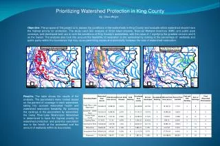
Download
1 / 50
500 likes | 521 Views
This presentation outlines the assessment, development, and implementation of stream management plans in the Schoharie Basin. It discusses the involvement of local communities, the evolution of the Schoharie Watershed Advisory Committee, and the implementation of best management practices. The presentation highlights the importance of stakeholder involvement and the progress made in local implementation.

E N D
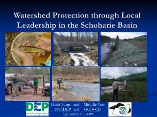
Watershed Protection through Local Leadership in the Schoharie Basin David Burns and Michelle Yost NYCDEP and GCSWCD September 15, 2009
Presentation Outline Assessment and Demonstration • Development of Stream Management Plans • Adoption of plans by communities and MOU with GCSWCD • Demonstration of Best Management Practices SMP Implementation • Evolution of the Schoharie Watershed Advisory Committee (SWAC) • SWAC structure • Stream Management Plan Implementation Fund East Kill entering Colgate Lake
Schoharie Basin • 3162 mile watershed • 13 Municipalities • Steep topography formed during last period of glaciation • Basin is located in Greene (76%), Schoharie • (16%), and Delaware (8 %) Counties • Part of Catskill System which supplies 40% of NYC water
Stream Management Plan • Multi-objective:to coordinate disparate mgt goals, traditions and practices that might otherwise be at cross purposes; • Community-based:to ensure inclusive, transparent planning involving all interested stakeholders, especially private streamside landowners; • Watershed-scale:because stream systems are impossible to manage effectively without considering ALL functional linkages.
Stakeholder Involvement • Hosted Stakeholder Planning Sessions • Hired a facilitator to host workshops and information sessions – completed stakeholder surveys • Formed individual stream-based project advisory committees to prioritize recommendations for their basin.
ManagementUnits Each stream was divided into management units to facilitate interpretation of conditions and to make management recommendations • Valley slope • Valley confinement • Historical channel alignment • Vertical and lateral controls • Clay exposures and bank erosion
Stream Feature Inventory Physical inventory of stream corridor conditions
Eroding Banks Clay Exposures Dump Sites
Other Components • Basic Watershed Planning (why, how, who) • Natural and Institutional Resources • Water quality assessment based on existing data • Introduction to Stream Processes • Management Unit Descriptions • Recommendations – specific and general
Local Implementation • All (8) municipalities in Greene County have gone through the SEQR process and adopted the relevant SMP; Conesville in Schoharie County also adopted Manor Kill plan. • Municipalities signed an Memorandum of Understanding with SWCDs to work collaboratively towards the implementation of stream management plans, and with stream issues; • All municipalities have appointed representatives to SWAC.
Local Implementation • DEP committed 2 million towards implementation of stream management plans; • GCSWCD, through DEP agreements, provide staffing for implementation; • SWAC developed an application process to guide implementation; • DEP and GCSWCD ensure project’s are consistent with Stream Management Plans;
Demonstration Projects Holden Stream Restoration – Batavia Kill Sugar Maples Stormwater/Riparian Project – Batavia Kill
Demonstration Project Goals • Develop a Network of Natural Channel Design Projects and Best Management Practices • Meet multiple objectives including improved/protected water quality, habitat creation, infrastructure and property protection • Training potential for local municipalities • Design projects that impact the stream to fit within the stream’s natural conditions thus limiting human-induced stream instabilities and the resulting erosion
Demonstration Projects Type of Project Number Stats • Full Channel Restoration 11 5.5 miles/157 acres • Riparian Buffer 8 1.3 miles/6.7 acres • Stormwater 2 • Infrastructure 7 Riparian planting along the Schoharie, 2009
Demonstration Projects Full Channel Restoration Conine Stream Restoration, Batavia Kill, 2007
Demonstration Projects Range from: Appropriate sizing of culverts Culvert Replacement, Schoharie Creek Tributary, 2008
Demonstration Projects Stormwater Tannersville Stormwater Retrofit
Conclusion – Part 1 • For the past thirteen years we’ve focused on assessment, stream management planning and developing demonstration projects. • Now that we’ve completed stream management plans for the majority of basin streams we are now moving into stream management plan implementation. Stream Assessment Schoharie Watershed Advisory Committee Riparian Restoration Demo
Moving beyond planning:Implementing Stream Management Plans through local leadership in the Schoharie basin
Sub-basin committees evolved to basin-wide Advisory Committee Schoharie Watershed Advisory Committee
SWAC Voting Committee Members • Towns within the Schoharie Creek basin Hunter, Windham, Jewett, Lexington, Ashland, Prattsville, Gilboa, Roxbury, and Conesville 9 • Villages within the Schoharie Creek basin Hunter and Tannersville 2 • County Legislator1 • Appointees from three subcommittees Highway, Education, and Recreation/Habitat 3 15 • Locally Driven • Appointed representatives (2) serving two year terms, with no term limits • Advisory Members – Local, State and Federal Agencies and Non-Government Organizations
SWAC Advisory Members • New York City Department of Environmental Protection • Greene County Soil and Water Conservation District • US Army Corps of Engineers • Greene County Highway • NYS Department of Transportation • NYS Department of Environmental Conservation • NYS Department of Health • Schoharie County Representatives • Delaware County Representatives • Greene County Planning Department • Cornell Cooperative Extension of Greene County • Catskill Watershed Corporation • Catskill Center • Greene Land Trust • Mountaintop Arboretum • Non-profit foundations: Catskill Mountain, Hunter, Community of Windham Foundations • Trout Unlimited
Subcommittees Outreach/Education Highway Supers Habitat/Recreation
General Guidelines • GCSWCD and DEP staff review project ideas, ensure consistency with stream management plans – GCSWCD assign staff person/funding category • GCSWCD and DEP coordinate with SWAC to draft action plan updates and revisions – these plans will guide the work and schedule for Schoharie stream management plan implementation • Meetings open to public STREAM MANAGEMENT PLAN IMPLEMENTATION Action Plan 2007 – 2009
Schoharie Basin Action Plan • Plans direct activities for SMP Implementation – developed by SWAC • Subject Areas within current Action Plan: • Program Administration • Education on Watershed Protection • Landowner Stream Assistance • Creative Stormwater Practices and • Critical Area Seeding • Planning and Assessment • Highway and Infrastructure Improvements • Recreation and Stream Habitat Improvement • On-going Activities Goal – integrate activities where there is a direct relationship to SMP implementation
Landowner Stream Assistance • Erosion • Invasives Plants • Riparian Buffers • Land Stewardship
Infrastructure Planning • Bridges • Culverts • Road Embankments • Utility Crossings • Floodplain Management
Stormwater Management/Low Impact • Ponds • Wetlands • Infiltration • Filtering Systems • Open Channels
Education & Outreach • Workshops • Newsletters • Public Meetings • School Programs • Presentations • Stream Clean-ups • Volunteer Plantings • AmeriCorps sponsorship • Kiosk Series
Supporting local decision-makers through coordinated workshops NYCDEP Schoharie Co. Planning Windham Planning Board NYSDEC
Recreation & HabitatEnhancement • Stream Access • Fisheries Improvement • Navigability • Habitat enhancement • Water quality protection Brown trout fingerlings
Planning & Assessment • Floodplain Management • Flood Response • Land Use/Open Space • Recreational Resources • Economic Development
Criteria for Funding Decisions • Project is within a municipality that has adopted the relevant SMP • Effects on stream stability and sediment transport • Water quality benefits • Public benefit to broader basin communities • Protects infrastructure • Improves habitats, general ecology or increases recreational access • Feasibility of project, approach is consistent with principles set forth in stream management plans
Increasing role of SWAC in Action Plan Development Process • Decision-making, setting priorities • Develop Application process • Review Criteria for scoring projects • Input on subcommittees/ serve as liaison to SWAC • Review outreach and reporting material
First round of proposals received August 1st • Culvert replacement – improve proper drainage, reduce erosion, enhance habitat • Thermal refuges study to determine where cold water refuges in Schoharie and West Kill exist to protect them • Streamside plantings and engineering services to stabilize eroding banks • Manor Kill Environmental Study Team/Stream Mngt. Implementation Program • Prattsville Stream Access • Stormwater retrofit for LEED project with multiple community benefits
Planning & Assessment Proposal Thermal remote sensing infrared image (FLIR) ~100 x 150 m Airborne thermal remote sensing Reflectance converted to temperature Converted to a GIS point coverage Slide complements of USGS
Education and Outreach Proposal Manor Kill Environmental Study Team Photos: Joyce Valenti
Key is integrating programs, technical assistance, & funding to support local communities toward addressing SMP activities on a watershed scale Stable riparian corridor Sugar Maples team Creek walk, Hunter Foundation SWAC Stormwater Management Roadside ditch protection Windham Mtn. stormwater project Tour Youth presentations
Thank You More Info www.catskillstreams.org David Burns Michelle Yost NYCDEP GCSWCD dburns@dep.nyc.govMichelle@gcswcd.com