Download
1 / 19
190 likes | 201 Views
This project documents and captures the condition of the historic African American Mt. Hope Cemetery in South Raleigh to preserve its history. Data collection and delivery will be completed in 6 weeks using Collector for ArcGIS and Microsoft Access.

E N D
Mt. Hope CemeteryStone Inventory Eric Wilson, Tom McKay and Bethany Williams
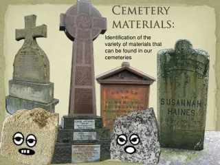
Where and Why • Mt. Hope Cemetery • Historic African American Cemetery • Where is Mt Hope? • South Raleigh • Fayetteville and Prospect Ave • Why collect the data now? • Many headstones are concrete or wood and are degrading • Recent tornado created a need to capture the “as is” state of the stones
Who • Client • Raleigh City Cemeteries Preservation Inc. • City Cemetery • Mt. Hope Cemetery • O’Rorke Cemetery • Timeframe • 6 Weeks for data collection and delivery • Staff • 1 Intern • 1 Analyst • 1 Project Manager
What we used • Software • Collector for ArcGIS • Field work • AGOL • Repository • ArcGIS Desktop • Data cleanup • Microsoft Access • Merging data after collection • Final Delivery • Reporting
Hardware Used • GPS – Trimble Geo 7x • Tablet – Samsung Tab Pro T320
In the end… • What was captured? • Location • Accuracy (60cm, sub-meter) • Capture method • Photos • Quality • Attributes • Inscription • Scouted ahead and designed GDB to reflect most efficient data entry • Post processed additions • Photo rotation • Spatial join on historical zones • Historical registry number • New grid number
In the end… • How did we check it? • For each photo… • Name and Inscription verification • Rotation verified • Location verified • What is the final product? • ArcGIS Online Map • Web App Builder • Microsoft Access Database • Searchable form and report • File Geodatabase • Photos as files (jpg, png etc.) not included
Opportunities for the data • Encourage Conservation • Historic Preservation • Search • Genealogy http://naldzgraphics.net/freebies/search-box-psd-download/ http://www.pixbam.com/genealogy
Comparison between City Cemetery and Mt. Hope Cemetery Spanish Flu Polio Peak Civil War
Comparison - Columbia, SC • Most affluent buried in Trinity Episcopal Cemetery
Challenges • Project Planning • Device Selection • Collection Method • Site • Data Collection • Powerless Power Packs • Review Pilot Data Process • Scheduling • Battery • Weather
Create Services (Desktop) Planned Workflow
Challenges cont. • Data Assembly • Sync • Stopped working • Upload not Download failures • Collector still was able to collect not return data to AGOL • We suspect Attachments were the problems (File Size) • Download each day directly from the machine • Merging • Develop custom process outside of normal ESRI Kool-Aid process • Used MS Access • Avoid GlobalID Locks maintained in File GDB • Additional QA/QC • Non-spatial checks • Duplicate entry • Duplicate photos • Final Construction • Microsoft Access saved the day again
Actual Workflow Create Services (Desktop)
Delivery and Deployment Demo • ArcGIS Online Web Map • Online Access to Photos and Location • Searchable • Microsoft Access Database • Custom Report • Photos embedded in report
Collector for the future • Subsurface Utility Engineering • Survey • Geospatial • Stay away from attachments if possible