Download
1 / 41
410 likes | 612 Views
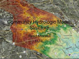
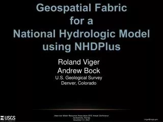
Geospatial Fabric for a National Hydrologic Model using NHDPlus. Roland Viger Andrew Bock U.S. Geological Survey Denver, Colorado. What Are the Components of a National Hydrologic Model?. Hydrologic models and software tools National “Geospatial Fabric”

E N D
Geospatial Fabric for a National Hydrologic Model using NHDPlus Roland Viger Andrew Bock U.S. Geological Survey Denver, Colorado
What Are the Components of a National Hydrologic Model? • Hydrologic models and software tools • National “Geospatial Fabric” • a consistent spatial context for any study, model application, data collection, etc. • Best available data • National extent • Freely available • Model-ready (processing and formatting)
Why Create a Geospatial Fabric? • Infrastructure for Nat’l Hydro Modeling (NHM) • Simplify simulation of streamflow at (almost) any point in US • Pre-process feature delineation & parameterization • Support PRMS, NWBM, SPARROW, WaterSmart Census • Method for indexing & sharing of results • Use hydrography to organize information resources related to hydrologic modeling
What Is a Geospatial Fabric? • GIS dataset of hydrologic modeling features • Sets of parameter tables • Methodology and software for derivation • Information architecture
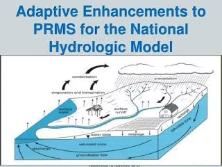
PRMS Conceptualization Hydrologic Response Units (HRUs) Surface Basin Infiltration Streamflow Subsurface Recharge Groundwater
Geospatial Fabric features dataset A nationally consistent set of geographic features used for hydrologic modeling • Points of Interest (POIs) • Stream segments • Hydrologic Response Units • Areas of homogenous hydrologic behavior
Geospatial Fabric parameter table set Indexed to GF features dataset, Based on a fixed set of ancillary data • Topology/connectivity for routing • Topography • Land Cover • Soils • Hydrogeology
Geospatial Fabric Methodology Defines/documents a nationally consistent set of methods for deriving features and parameters • Turning NHDPlus into something more relevant for modeling • Automated derivation • Usesbest available data • Relevant research and development in the field of hydrologic modeling to answer increasingly complex questions, and to take advantage of improved data sources as they become available. • Information architecture for • model application • Distribution • Comparability • interoperability • This archive process is a key to coupling models from diverse scientific disciplines.
Aggregate NHDPlus catchments based on Points of Interest (POIs) to make HRUs Geospatial Fabric Methodology
GF feature dataset: Points of Interest • Aggregate NHDPlus features based on POIs to define segments & HRUs • POIs: • Gages II USGS Reference/non Ref. Gages • SPARROW • National Weather Service River Forecast Centers • Major confluences and waterbody inlets/outlets • Travel time points (< 1 day) • Elevation bands (500m) • User supplied • HUC12 outlets
GF feature dataset: Segments Minimally sufficient set of NHDPlus Flowlines to connect POI pairs, Dissolved into a single feature
GF feature dataset: Incremental Contributing Areas (ICAs) Aggregate all NHDPlus Flowline Catchments associated with a POI
GF feature dataset: Hydrologic Response Units Split ICAs by segment into “left-bank” and “right-bank” areas
GF feature dataset: Hydrologic Response Units
GF parameter sets: Current production • NLCD 2001 • STATSGO • NHD local-res waterbodies • Hydrogeology (permeability from Gleeson et al, 2011) • Pre-processed • Elevation • Aspect • Slope • X/Y/lat/long • Area • Soil moisture • Soil recharge • Soil type • Fluxes • Imperviousness • Waterbodies • Cover type • Cover density • Interception • Transmissivity
GF parameter sets: plans for future • NLCD 2006, 2010, etc • SSURGO • NASA imagery • Improve empirical methods based on historical images • Huge help when using projections w/limited content • Land cover forecasts • Urbanization/imperviousness • Snow cover area/equivalence • Canopy height for stream shading • Dynamic parameter generation • GDP, etc
Example of aggregated NHDPlus in the Apalachicola-Chattahoochee-Flint (ACF) River basin, Georgia ~50,000 km2 Jacob LaFontaine (GA WSC)
Geospatial Fabric: 7 major waterbodies 313 points of interest (POI) 652 hydrologic response units (HRUS) Original NHDPlus data: 5233 waterbodies 26,208 flowlines 25,908 catchments Jacob LaFontaine (GA WSC)
GF as Information Architecture Enables subsetting and multi-scale modeling
Coarse Resolution Hydrologic Model GF as Information Architecture Enables subsetting and multi-scale modeling Coarse HRUs based on stream gages and other “real-world” locations to enable nesting of models
Coarse Resolution Hydrologic Model GF as Information Architecture Enables subsetting and multi-scale modeling Streamgage Hydrologic Response Unit (HRU) Coarse HRUs based on stream gages and other “real-world” locations to enable nesting of models
GF as Information Architecture Enables subsetting and multi-scale modeling Pull a stand-alone coarse resolution model from the larger one Coarse HRUs based on stream gages and other “real-world” locations to enable nesting of models
Coarse Resolution Hydrologic Model GF as Information Architecture Enables subsetting and multi-scale modeling Pull a stand-alone coarse resolution model from the larger one Nest a stand-alone fine resolution model Coarse HRUs based on stream gages and other “real-world” locations to enable nesting of models
Coarse Resolution Hydrologic Model GF as Information Architecture Enables subsetting and multi-scale modeling Pull a stand-alone coarse resolution model from the larger one Nest a stand-alone fine resolution model Stand-alone models can be re-calibrated and nested back into the coarse resolution model Coarse HRUs based on stream gages and other “real-world” locations to enable nesting of models
Lumen: tool for exploiting Information architecture • Stream network • Gages • Calibration rounds based on gages
GF: how is it different? • NHDPlus • complexity • National Hydrography Dataset • scale/resolution • stability • ArcHydro • tool set, like the GIS Weasel • data model
Conclusions for the Geospatial Fabric • Nationally consistent set of features • Scale, detail relevant for hydrological modeling • One of many possible sets of parameters • Ready to be applied to other data streams • Establishes well-known/community-based methods • Information handling approach: • More than just a data set!
Questions http://wwwbrr.cr.usgs.gov/mows
Loch Vale Watershed, CO NHDPlus Region 10Lower John Walker (WI WSC)
Loch Vale Watershed, CO 100km2 1.5km2
Loch Vale Watershed, CO 100km2 1.5km2
Hydrologic Model (parameterization) Spatial parameters • GIS interface • GDP Vegetation Impervious Area Land Cover Terrain and Hydrology
Current Condition Climate data for model forcing available from GDP Andy Bock (CO WSC) Greg McCabe (NRP) Dwight Atkinson (EPA)
GeoData Portal (GDP) Hydrologic Response Units (HRUs) Shape File Best Available Data GDP HRU summary Mapped to model format
What happened behind the scenes? Statistical summaries of gridded output by basin subunits Gridded output