Download
1 / 14
140 likes | 246 Views
This project aims to add a third bridge across Lake Washington, connecting key areas and minimizing impact on existing infrastructure and natural environments. Evaluation of two alternatives, North Crossing and South Crossing, with detailed data on surroundings and impact assessment. The preferred alternative reduces congestion and the need for extensive parcel acquisition.

E N D
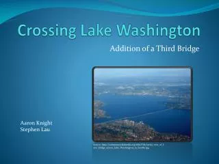
Crossing Lake Washington Addition of a Third Bridge Aaron Knight Stephen Lau Source: http://commons.wikimedia.org/wiki/File:Aerial_view_of_I-520_bridge_across_Lake_Washington_in_Seattle.jpg
Objectives • Connect I-5 to I-405 • Minimize impact on existing housing and businesses • Connect areas of greatest density • Use the most effective bridge span length • Minimize impact on recreational areas • Minimize impact on wetland areas • Provide available Park & Ride Service • Minimize impact on school or historical sites • Suit the land topography
Project Area Source: Google Earth
Alternatives North Crossing South Crossing
North Crossing • Length of Segment: 6.42 Miles • Length of Bridge:0.9 Miles • Parcels Within 250’: 995 • Average Density, 10 miles: 7553 per/mi2
North Crossing Within 500’: • Wetlands: 0 • Parks: 2 • Schools: 3 • Historical Sites: 0 • Park & Rides: 2
North Crossing Topography information: • Significant elevation change, tunnel required
South Crossing • Length of Segment: 4.62 Miles • Length of Bridge: 2.74 Miles • Parcels Within 250’: 287 • Average Density within 10 miles: 6740 per/mi2
South Crossing Within 500’: • Wetlands: 0 • Parks:1 • Schools: 3 • Historical Sites: 0 • Park & Rides: 2
South Crossing Topological information: • Relatively constant elevation
Preferred Alternative • Shorter Roadway • No tunnel required • Less parcel acquisition necessary • Reduces congestion for I-405 in Renton
Resources • UW ESS Department http://gis.ess.washington.edu/data/raster/tenmeter/byquad/index.html • King County GIS https://wagda.lib.washington.edu/DATA/geography/wa_counties/king/index.html • WSDOT http://www.wsdot.wa.gov/mapsdata/geodatacatalog/default.htm