Download
1 / 19
220 likes | 654 Views
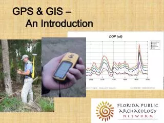
GPS & GIS – An Introduction. Where Will This Take Us?. What is GPS? What is GIS? How do GPS and GIS work? How will they help us?. ?. Find This!. What is GPS?. GPS stands for G lobal P ositioning S ystem

E N D
Where Will This Take Us? • What is GPS? What is GIS? • How do GPS and GIS work? • How will they help us? ? Find This!
What is GPS? • GPS stands for Global Positioning System • GPS is a satellite navigation system designed to provide accurate position, velocity, and time information almost anywhere in the world • the present system is known as NAVSTAR - NAVigation Satellite Timing And Ranging • the GPS program operated and controlled by the US Department of Defense
How does GPS work? • Each satellite broadcasts its orbital position as a modulated signal • Receiver determines the difference between the time signal from the satellite and its own internal clock • The distance from the satellite can be calculated using the speed of light (300,000 km/second) • Position and distance from 3 or 4 satellites allows triangulation of receiver’s position
Space Segment • A constellation of 24 orbiting satellites with 3-4 spares • Orbit at a distance of 11,000 miles • Each satellite contains several very precise atomic clocks • orbit roughly every 12 hours, but they are not geosynchronous
Control Segment • There are five Control Stations around the world • Stations monitor satellites as they pass overhead by measuring the distance from the Control Station to the satellites • Master Control Station determines satellite conditions (orbit, clock, health status) and calibrates the satellite’s clock
User Segment • Accuracy is dependent on the kind of receiver • Navigation (Recreation) grade – least accurate • Mapping grade – accurate • Survey grade – most accurate • Costs range from $100 to $30,000
Error in Satellite Signals DOP = Dilution of Precision (This means that the signal degrades)
Error in Satellite Signals DOP projection for 23 January 2009 (Our data collection day)
Geographic Information Systems - GIS • GIS is a spatial database with a strong visual display component • GIS is not primarily a mapping program • GIS was developed in the early 1980s, but its acceptance and development outside of the environmental sciences has been slow
GIS Data Models • Raster Model • The first GIS model developed • Based on grids of cells that are assigned values and grouped into layers • Vector Model • Uses points, lines, and polygons define data classes • Grouped into themes or layers
GIS – Raster Data Model ROWS Grid Cell COLUMNS
GIS – Raster Data Model (cont) House Road Archaeological Site
GIS – Raster Data Model (cont) 0 0 0 0 R 0 0 0 0 0 H 0 0 0 0 R 0 0 0 0 0 R 0 0 0 0 0 0 0 R 0 0 S S S 0 S 0 0 S 0 0 R S 0 S S 0 S 0 R 0 0 S S 0 0 S 0 R 0 0 0
GIS – Vector Data Model House Road Archaeological Site
GIS – Vector Data Model (cont) House Road Archaeological Site
GIS Models - Combined • We’ll use a combination of raster imagery and vector layer files to build our geo-database • Let’s see a real-world application