Download
1 / 53
610 likes | 1.27k Views
Earth’s internal processes กระบวนการเปลี่ยนแปลง ภายในโลก.

E N D
Earth’s internal processesกระบวนการเปลี่ยนแปลงภายในโลก
กล่าวไว้ว่าการหมุนเวียนของกระแสความร้อนภายในโลกส่งผ่านความร้อนจากแก่นโลกขึ้นมาสู่ชั้นแมนเทิล ซึ่งมีลักษณะเป็นของไหลที่มีสถานะกึ่งแข็งกึ่งเหลว และหมุนเวียนจากส่วนล่างขึ้นไปสู่ส่วนบนส่งผลให้เปลือกโลกซึ่งเป็นของแข็งปิดทับอยู่บนสุดเกิดการแตกเป็นแผ่น (Plate) และเคลื่อนที่ในลักษณะเข้าหากัน แยกออกจากกัน และไถลตัวขนานออกจากกัน Convection current theory ทฤษฎีวงจรการพาความร้อน
Continental Drift Theory ทฤษฎีทวีปเลื่อน ค.ศ.1915 นักวิทยาศาสตร์ชาวเยอรมันชื่อ Alfred Wegener หนังสือ The origin of Continental and Oceans • สมมติฐานว่า เมื่อราว 250 ล้านปีก่อน ทวีปต่าง ๆ เคยติดกันเป็นทวีปขนาดใหญ่เรียกว่า พันเจีย (Pangea) ต่อมามีการเคลื่อนตัวแยกออกจากกัน • พื้นทวีปเคลื่อนที่โดยแรงหนีศูนย์กลาง พื้นทวีปจึงเคลื่อนเข้าหาเส้นศูนย์สูตรและทวีปอเมริกายังเคลื่อนไปทางทิศตะวันตก จนมาอยู่ในตำแหน่งปัจจุบัน • หลักฐานที่เชื่อว่าแผ่นทวีปเคลื่อนที่นี้คือ ในปัจจุบันได้พบชนิดหิน และฟอสซิลที่เกิดในสภาวะแวดล้อมเดียวกันแต่อยู่คนละทวีปซึ่งห่างไกลกันมาก นอกจากนี้หินอายุเดียวกัน ที่อยู่ต่างทวีปกันมีรูปแบบสนามแม่เหล็กโลกโบราณคล้ายคลึงกัน และขอบของทวีปสามารถเชื่อมตัวประสานแนบสนิทเข้าด้วยกันได้
Sea Floor Spreading Theory ทฤษฎีเปลือกโลกใต้มหาสมุทรแยกตัว ค.ศ.1960sAmerican geologist Harry H. Hess • Theory of lithospheric evolution that holds that the ocean floors are spreading outward from vast underwater ridges • จากปรากฏการณ์การแตกตัวและแยกออกจากกันของพื้นใต้มหาสมุทร • - Discovery mid-ocean ridgeการค้นพบแนวเทือกเขากลางมหาสมุทร • samples of the deep ocean floor show that basaltic oceanic crust and overlying sediment become progressively younger as the mid-ocean ridge is approached, and the sediment cover is thinner near the ridge ตัวอย่างเปลือกโลกที่ใต้ทะเลลึกยิ่งมีอายุน้อยและบางลงเมื่อเข้าใกล้แนวเทือกเขากลางมหาสมุทร • rock making up the ocean floor is considerably younger than the continents หินพื้นสมุทร มีอายุน้อยกว่า พื้นทวีป
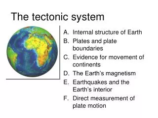
ทฤษฎีการเคลื่อนที่ของแผ่นเปลือกโลก(Plate Tectonic Theory) เกิดจากการนำทฤษฎีทวีปเลื่อนและทวีปแยกมารวมกันตั้งเป็นทฤษฎีใหม่ขึ้นมาโดยกล่าวไว้ว่าเปลือกโลกทั้งหมดแบ่งออกเป็นแผ่นที่สำคัญ จำนวน 13 แผ่น โดยแต่ละแผ่นจะมีขอบเขตเฉพาะได้แก่ แผ่นอเมริกาเหนือ อเมริกาใต้ ยูเรเซีย แอฟริกา อินเดีย แปซิฟิก แอนตาร์กติก ฟิลิปปินส์ อาหรับ สกอเทีย โกโก้ แคริเบียน และนาซก้า แผ่นเปลือกโลกทั้งหมดไม่หยุดนิ่งอยู่กับที่จะมีการเคลื่อนที่ตลอดเวลาใน 3 แบบ ได้แก่การเคลื่อนที่เข้าหากัน แยกออกจากกัน และไถลตัวขนานออกจากกันซึ่งผลของการเคลื่อนที่ของเปลือกโลกทำให้เกิดปรากฎการณ์ต่าง ๆ ขึ้น เช่น แผ่นดินไหว เทือกเขา ภูเขาไฟ และกระบวนการเกิดแร่และหิน
การเคลื่อนที่ของแผ่นเปลือกโลกPlate Tectonics • Divergent boundaries เคลื่อนที่แยกจากกัน • Convergent boundaries เคลื่อนที่เข้าหากัน • Oceanic-continental convergence • Oceanic-oceanic convergence • Continental-continental convergence • Transform boundaries เคลื่อนที่ไถลตัวขนานกัน แบบด้านข้าง แบบเฉือน หรือแบบเปลี่ยนรูป
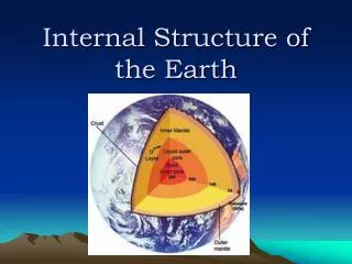
LITHOSPHERE AND ASTHENOSPHEREธรณีภาค และฐานธรณีภาค • The lithosphere ธรณีภาคประกอบด้วย • the upper rigid mantle :ของแข็งแมนเทิลชั้นบน • the overlying oceanic or continental crust : มีเปลือกทวีปหรือเปลือกมหาสมุทรพาดทับชั้นแมนเทิลอีกที • The asthenosphere is capable of flow. ฐานธรณีภาคสามารถไหลได้เนื่องจากอุณหภูมิในชั้นนี้สูงกว่าจุดหลอมเหลวของหินเล็กน้อยจึงมีบางส่วนหลอมเหลว
DIVERGENCE การเคลื่อนที่แยกจากกัน • Heat flow causes the lithosphere to break apart (divergence) and form a rift valley. These rift valleys form the boundaries between plates and new rock is formed as the magma cools. This is referred to as sea-floor spreading.การไหลของความร้อนทำให้ชั้นธรณีแตกออกเกิดเป็นแนวแยกหุบเขา • Older rock is pushed aside where new rock is forming. As distance from mid-ocean ridges increases, age of rock also increases. Most divergent boundaries have mid-ocean ridges with deep rift valleys along their entire length. หินเก่าจะถูกดันออกไปขณะที่เกิดหินใหม่จาการแทรกตัวของแมกมาตามรอยแยกเย็นตัวลง OLDER ROCK OLDER ROCK HEAT FLOW
DIVERGENCE WITH TRANSFORM FAULTSการเคลื่อนที่แยกจากกันพร้อมการเคลื่อนที่ไถลตัวขนาน • Rift valleys are broken into segments by transform faults. Movements along these fractures are a source of earthquakes that occur along the ridge. • รอยแยกหุบเขาอาจแตกเป็นช่วงเรียกว่า รอยแตกแบบเฉือน transform faults
mid-ocean ridges แนวเทือกเขากลางสมุทร เกาะไอซ์แลนด์
TRANSFORM BOUNDARYการเคลื่อนที่แบบเฉือน • At the boundaries of some areas, the lithospheric plates are sliding past each other. Frequent earthquakes occur along these transform boundaries as huge masses of rock move.
TRANSFORM BOUNDARYการเคลื่อนที่แบบเฉือน ตัวอย่างบริเวณที่เกิดการเคลื่อนที่แบบเฉือน San Andreas Fault
TRANSFORM BOUNDARYการเคลื่อนที่แบบเฉือน ตัวอย่างบริเวณที่เกิดการเคลื่อนที่แบบเฉือน • The San Andreas Fault, located in western California • ทิศตะวันตกของ แคลิฟอร์เนีย เรียกว่าSan Andreas Fault • the source of frequent earthquakes. มักเกิดแผ่นดินไหวบ่อยครั้ง • the Pacific Plate and the North American Plates are sliding past each other. เกิดจากแผ่นเปลือกโลกแปซิฟิกไถลกับแผ่นอเมริกาเหนือ • average rate about 5 cm per year. อัตราเฉลี่ยปีละ 5 เซนติเมตร • Some areas have not moved for centuries. Pressure has been building and is thought to be the most likely places for future earthquakes. • บางพื้นที่อาจไม่มีการเคลื่อนไหวเป็นศตวรรษ ความดันอาจถูกสะสมซึ่งอาจทำให้เกิดแผ่นดินไหวรุนแรงในอนาคต
CONVERGENCE:ocean-continental plate boundaryการเคลื่อนที่เข้าหากันแผ่นทวีปกับแผ่นมหาสมุทร • Continental crust is made of granite, which is less dense than ocean crust, which is made of basalt. • แผ่นทวีปเป็นหินแกรนิต มีความหนาแน่นน้อยกว่าแผ่นมหาสมุทร ซึ่งเป็นหินบะซอลต์ • The more dense ocean crust subducts (goes under) continental crust, forming a deep trenchon the ocean floor. • แผ่นมหาสมุทรที่หนาแน่นกว่าจะมุดลงใต้แผ่นทวีปเกิดเป็นร่องเหวมหาสมุทร trench • High temperatures and pressures in the asthenosphere cause the subducting plate to melt. • อุณหภูมิและความดันที่สูงในชั้นฐานธรณีทำให้แผ่นที่มุดลงมาหลอมละลาย
CONVERGENCE:ocean-continental plate boundaryการเคลื่อนที่เข้าหากันแผ่นทวีปกับแผ่นมหาสมุทร • Magma then rises to the surface and escapes in volcanic eruptions, forming major mountain ranges on the continent. • แมกม่าจะดันตัวสูงขึ้นสู่พื้นผิวและหนีออกมาในรูปแบบของการเกิดภูเขาไฟ การเกิดแนวเทือกเขาบนทวีป • Eruptions can be very violent and earthquakes at subduction boundaries occur much deeper in the lithosphere than at other plate boundaries. • การประทุของภูเขาไฟแผ่นดินไหวจากการมุดตัวของแผ่นเปลือกโลกมักเกิดรุนแรงกว่าในการเคลื่อนที่แผ่นเปลือกโลกรูปแบบอื่น
CONVERGENCE:ocean-continental plate boundaryการเคลื่อนที่เข้าหากันแผ่นทวีปกับแผ่นมหาสมุทร
CONVERGENCE:oceanic-oceanic plate boundaryการเคลื่อนที่เข้าหากันแผ่นมหาสมุทรกับแผ่นมหาสมุทร • Where two ocean plates converge, the older, more denseocean crustal plate subducts under the younger, less dense. • แผ่นที่มีอายุมากกว่าซึ่งมีความหนาแน่มากกว่าจะมุดลงใต้แผ่นที่มีอายุน้อยกว่าซึ่งมีความหนาแน่นต่ำกว่า • the older crust is farther from the mid-ocean ridge where it was originally formed as new seafloor. • แผ่นที่มีอายุมากกว่ายิ่งเคลื่อนที่ไหลออกจากแนวเทือกเขากลางสมุทร • Island arcs are formed near ocean trenches as subducting plates are melted and rise to the surface as volcanic eruptions. • แนวเกาะรูปโค้งIsland arcsจะเกิดขึ้นใกล้ร่องเหวสมุทรที่มุดลงแล้วหลอมละลายดันตัวขึ้นสู่พื้นผิวในรูปแบบการประทุของภูเขาไฟ • Island arcs are found along the Aleutian Trench and Tonga Trench in the Pacific Ocean
CONVERGENCE:oceanic-oceanic plate boundaryการเคลื่อนที่เข้าหากันแผ่นมหาสมุทรกับแผ่นมหาสมุทร
CONVERGENCE:continental-continental plate boundaryการเคลื่อนที่เข้าหากันแผ่นทวีปกับแผ่นทวีป • If converging plates are both carrying continents, the continents may be welded into a single larger continent. This converging boundary is known as a collision boundary. The collision causes the lithosphere to be pushed up into a mountain range. การเคลื่อนที่เข้าหากันมักทำให้เกิดการเชื่อมกันแล้วยกตัวขึ้นเป็นแนวเทือกเขา
CONVERGENCE:continental-continental plate boundaryการเคลื่อนที่เข้าหากันแผ่นทวีปกับแผ่นทวีป
CONVERGENCE: India colliding with Asiaแผ่นอินเดียชนกับแผ่นเอเซีย • The Himalayan Mountains are an example of a collision boundary that is still forming today. • ทำให้เกิดเทือกเขาหิมาลัย • India is pushing northward into China at a rate of about 5 cm each year. • ประเทศอินเดียถูกดันขึ้นไปทางทิศเหนือสู่ประเทศจีนด้วยอัตราเร็วปีละ 5 เซนติเมตร • India is now welded to the Eurasian continent with the world’s highest mountains and frequent earthquakes. • ประเทศอินเดียถูกเชื่อมกับทวีปยูเรเชียด้วยเทือกเขาและเกิดแผ่นดินไหวบ่อยๆ
CONVERGENCE • This map shows the Australian-Indian plate colliding with the Eurasian plate. Find India and the Himalayan Mountains. HIMALAYAN MOUNTAINS INDIA
Physical world map…locations of mountain rangesแนวเทือกเขา • Mountain ranges are formed at active plate boundaries where tectonic plates are converging. Cascades Himalayas Andes
Earthquakes แผ่นดินไหว แผ่นดินไหว เป็นภัยพิบัติทางธรรมชาติที่เกิดจากการสั่นสะเทือนของพื้นดิน อันเนื่องมาจากการปลดปล่อยพลังงานเพื่อระบายความเครียดที่สะสมไว้ภายในโลกออกมาอย่างฉับพลันเพื่อปรับสมดุลย์ของเปลือกโลกให้คงที่ ขนาดของแผ่นดินไหวตามมาตราริคเตอร์ (Richter) M = log A- log Ao เมื่อ M เป็นขนาดแผ่นดินไหว A เป็นความสูงของคลื่นสูงสุด Ao เป็นความสูงของคลื่นที่ระดับศูนย์ มีค่าเท่ากับ 0.001 มม.
Deeper focus earthquakes occur in subduction zones along convergent plate boundaries. Shallow focus earthquakes occur along mid-ocean ridges and transform boundaries.
EARTHQUAKE FOCI DEPTH [Japan trench region] • Japan is an island arc created from the subduction of the Pacific Plate. Earthquakes in western Japan are deeper than earthquakes in eastern Japan.
Many earthquakes and volcanic eruptions surround the Pacific Ocean. This is known as the “Ring of Fire”.
Tsunami การเกิดคลื่นยักษ์ A B D C
Volcanism กระบวนการณ์ปลดปล่อยพลังงานออกมา (จากภายในดาวเคราะห์หรือดวงจันทร์ของดาวเคราะห์) โดยการระเบิดออกของภูเขาไฟหรือการพุ่งขึ้นของน้ำพุร้อน active volcanoes ภูเขาไฟมีพลัง คือ ภูเขาไฟที่ยังมีการระเบิด เกิดขึ้นบ่อย ๆ domant ภูเขาไฟหมดสภาพ ภูเขาไฟที่ไม่มีการระเบิดมานานเรียกว่า extinct ภูเขาไฟดับสนิท คือ ภูเขาไฟที่หยุดการระเบิดไปแล้วอย่างถาวรในบริเวณ
Volcanic activity occurring at subduction boundaries usually results in more violent eruptions. Figure #1 Mount St. Helen’s Figure #2 Mt. Uluigalau Volcano, Fiji
TECTONIC HOT SPOTS • Not all volcanism occurs at plate boundaries. Hot spots are usually located in the middle of lithospheric plates. The hot spot seems to remain in the same location while the plate moves over it. This results in a chain of extinct volcanic islands like the Hawaiin Islands. Direction of Plate Movement North KAUAI OAHU MOLOKAI Active Volcano is over the Hot Spot MAUI HAWAII
ภูเขาไฟสลับชั้น stratovolcanoesหรือComposite volcano Fujiyama Principal Types of Volcanoes • steep-sided • symmetrical cones
PLATE TECTONICS AND THE ROCK CYCLE New rocks are continually being created due to tectonic forces. • Igneous rocks form from the solidification of magma and volcanic lava. • Metamorphic rocks are changed by the heat and pressure caused by converging of tectonic plates. • Sedimentary rocks are created when other rocks are weathered and eroded, deposited as sediments, and then compacted and cemented.Find the location of each of these processes in the diagram below.
IgneousRocks หินอัคนี Volcanic rocks(also called extrusive igneous rocks) หินภูเขาไฟหรือหินอัคนีพุ เกิดจากการเย็นตัวลงอย่างรวดเร็วของหินหนืดที่ดันตัวพุออกมานอกผิวโลกเป็นลาวา (Lava) ผลึกแร่มีขนาดเล็กหรือไม่เกิดผลึกเลย เช่น หินบะซอลต์ (Basalt) หินแอนดีไซต์ (Andesite) หินไรโอไลต์ (Rhyolite) Plutonic rocks(also called intrusive igneous rocks) หินอัคนีแทรกซอนหรือ หินอัคนีบาดาล เกิดจากการเย็นตัวลงอย่างช้า ๆ ของหินหนืดใต้เปลือกโลก มีผลึกแร่ขนาดใหญ่ (>1 มิลลิเมตร) เช่นหินแกรนิต (Granite) หินไดออไรต์ (Diorite) หินแกบโบร (Gabbro)
Sedimentary rocks หินตะกอน - หินชั้นเนื้อประสม(Clastic Sedimentary Rock) เป็นหินชั้นที่เนื้อเดิมของตะกอน พวกกรวด ทราย เศษหินและดิน ยังคงสภาพอยู่ให้พิสูจน์ได้ เช่น หินทราย (Sandstone) หินดินดาน (Shale) หินกรวดมน (Conglomerate) เป็นต้น • หินเนื้อประสาน(Nonclastic Sedimentary Rock) เป็นหินที่เกิดจากการตกผลึกทางเคมี หรือจากสิ่งมีชีวิต มีเนื้อประสานกันแน่นไม่สามารถพิสูจน์สภาพเดิมได้ เช่น หินปูน (Limestone) หินเชิร์ต (Chert) • เกลือหิน (Rock Salte) ถ่านหิน (Coal) เป็นต้น
ตัวอย่างหินตะกอน ชั้นหินเชิร์ต หินทรายแสดงชั้นเฉียงระดับ ชั้นหินทรายสลับชั้นหินดินดาน หินกรวดมน
Metamorphic Rock หินแปร - การแปรสภาพบริเวณไพศาล(Regional metamorphism) เกิดเป็นบริเวณกว้างโดยมีความร้อนและความดันทำให้เกิดแร่ใหม่หรือผลึกใหม่เกิดขึ้น มีการจัดเรียงตัวของแร่ใหม่ และแสดงริ้วขนาน (Foliation) อันเนื่องมาจากแร่เดิมถูกบีบอัดจนเรียงตัวเป็นแนวหรือแถบขนานกัน เช่น หินไนส์ (Gneiss) หินชีสต์ (Schist) และหินชนวน (Slate) เป็นต้น - การแปรสภาพสัมผัส(Contact metamorphism) เกิดจากการแปรสภาพโดยความร้อนและปฏิกิริยาทางเคมีของสารละลายที่ขึ้นมากับหินหนืดมาสัมผัสกับหินท้องที่ ไม่มีอิทธิพลของความดันมากนัก ปฏิกิริยาทางเคมีอาจทำให้ได้แร่ใหม่บางส่วนหรือเกิดแร่ใหม่แทนที่แร่ในหินเดิม หินแปรที่เกิดขึ้นจะมีการจัดเรียงตัวของแร่ใหม่ ไม่แสดงริ้วขนาน (Nonfoliation) เช่น หินอ่อน (Marble) หินควอตไซต์ (Quartzite)