The tectonic system
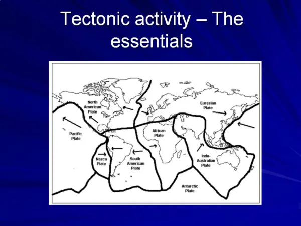
The tectonic system. Internal structure of Earth Plates and plate boundaries Evidence for movement of continents The Earth’s magnetism Earthquakes and the Earth’s interior Direct measurement of plate motion. A. Internal structure of the Earth. By physical properties

The tectonic system
E N D
Presentation Transcript
The tectonic system Internal structure of Earth Plates and plate boundaries Evidence for movement of continents The Earth’s magnetism Earthquakes and the Earth’s interior Direct measurement of plate motion
A. Internal structure of the Earth • By physical properties • By chemical composition
Atmosphere Hydrosphere Lithosphere Asthenosphere Mesosphere Outer core Inner core Divisions of the Earth by physical properties • Atmosphere - gas • Hydrosphere - liquid • Lithosphere - solid rock • Asthenosphere -rock, partly (5-25%) molten ~100 km ~250 km • Mesosphere - solid rock 2900 km • Outer core - liquid, metallic 5200 km • Inner core - solid, metallic 6370 km
Atmosphere Hydrosphere Crust Mantle Core Divisions of the Earth by chemical composition • Atmosphere - (nitrogen, oxygen ) • Hydrosphere - (Water: oxygen, hydrogen) • Crust (oxygen, silicon, aluminum, iron, magnesium) 5-70 km • Mantle (oxygen, silicon, magnesium, iron) 2900 km • Core - iron, nickel 6370 km
Continental crust – less dense rock with more silicon, aluminum Oceanic crust – more dense rock with more iron, magnesium Divisions of the Earth by chemical composition
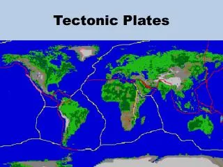
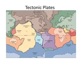
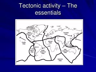
B. Plates and plate boundaries • Lithosphere is divided into plates. • Plates are in relative motion at speeds of a few cm per year • There are 3 types of plate boundary • Spreading centres • Subduction zones • Transform faults
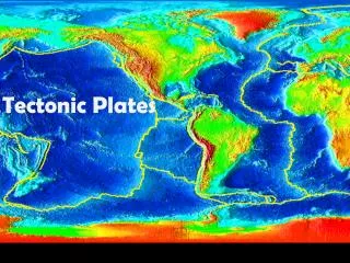
Plates and plate boundaries • Map of principal plates
1. Spreading centres • Mid-Atlantic ridge
1. Spreading centres Pillow lavas from the ocean floor
1. Spreading centres • Iceland
1. Spreading centres • Cross-section of a spreading centre
1. Spreading centres: summary • Occur beneath the oceans • Marked by a mid-ocean ridge several thousand km wide, rising 2 or 3 km above surrounding ocean floor • Site of submarine volcanoes and earthquake activity • New lithosphere formed by ocean-floor spreading • Plates move apart (a few centimetres per year)
2. Subduction zones • Deep trenches around the Pacific Ocean P&S 1.12
2. Subduction zones • Subduction zone volcanoes (Mount St. Helens - before)
2. Subduction zones • Subduction zone volcanoes (Mount St. Helens – after)
2. Subduction zones • Where subduction occurs close to a continental margin, there is often a mountain belt (orogen) • Rocks within orogen are crumpled (deformed)
2. Subduction zones: summary • Subduction zone or convergent plate boundary • Deep ocean trench (up to 11 km deep) • Benioff zone of deep earthquakes • Melting in mantle produces magma • Volcanic arc • One plate moves under another (a few centimetres per year) • Orogens (mountain belts) form where subduction zones affect continental crust
Transform faults (transcurrent plate boundaries) 3. Transform faults
3. Transform faults • San Andreas Fault
3. Transform faults • Dextral or right-lateral transform fault P&S 1.17
Right-lateral transform fault 3. Transform faults Shallow earthquakes Crust Lithosphere Right-lateral transform fault Asthenosphere
Left-lateral transform fault 3. Transform faults Shallow earthquakes Crust Lithosphere Left-lateral transform fault Asthenosphere
3. Transform faults • Many small transform faults occur along the mid-ocean ridges • Larger transform faults cut continental crust • Many shallow earthquakes
C. Evidence for moving continents • Common sense tells us the Earth is solid • Until ~1960 most scientists also believed continents remained fixed • Lines of evidence supporting moving plates • Match of geologic structures • Fossils • Glaciation and climate • Paleomagnetism • Match of continent outlines • Seismicity • Direct measurement of plate movement by GPS
1. Match of continent outlines Some continents show 'jig-saw' fit
2. Match of rock units between continents Very similar rock units are now separated by oceans
3. Fossil evidence Fossils of very similar land animals and plants are now separated by oceans
4. Glaciation and climate • Locations of ice sheets at 350-300 Ma - no sense on modern map • Can be explained if "Gondwanaland" is reassembled
D. Paleomagnetism • Before 60's most geophysicists claimed that Earth was too rigid to allow continental drift. • But first measurements of movement came geophysics: studies of Earth's magnetism. • The Earth's magnetic field • Remanent magnetization • Magnetic reversals and anomalies on the ocean floor
1. Earth's magnetic field • Earth behaves approximately as if there is a bar magnet in the core
1. Earth's magnetic field • Field at any place has an inclination (steepness) and a declination (direction) • Inclination indicates distance from pole • Declination indicates direction to pole Inclination angle
2. Remanent magnetism “Ma” in the diagrams signifies “Million years before present” • Some ancient rocks were (weakly) magnetized when formed - "Remanent magnetism" • "Fossil compass needles" • If age of rocks is known, remanent magnetism indicates the ancient location of the pole 500 Ma
2. Remanent magnetism 100 225 0 Ma 270 400 500 600 Ma “Ma” in the diagrams signifies “Million years before present” • Some ancient rocks were (weakly) magnetized when formed - "Remanent magnetism" • "Fossil compass needles" • If age of rocks is known, remanent magnetism indicates the ancient location of the pole • Pole appears to have wandered through time
2. Remanent magnetism 100 225 0 Ma 270 400 500 600 Ma “Ma” in the diagrams signifies “Million years before present” • Some ancient rocks were (weakly) magnetized when formed - "Remanent magnetism" • "Fossil compass needles" • If age of rocks is known, remanent magnetism indicates the ancient location of the pole • Pole appears to have wandered through time • Apparent polar wander path (APWP) • Hence either the pole moved or the continent moved
2. Remanent magnetism 0 Ma “Ma” in the diagrams signifies “Million years before present” • Different continents show different APWPs • Hence it must be the continents that moved North America Europe
2. Remanent magnetism • Other changes are recorded by remanent magnetism • N. and S. magnetic poles appear to have "flipped' through time Volcano showing magnetized lava flows
2. Remanent magnetism • N. and S. magnetic poles appear to have "flipped' through time Gary A Glatzmaier University of California, Santa Cruz www.es.ucsc.edu/~glatz
2. Remanent magnetism • Time scale of magnetic reversals
3. Reversals and ocean-floor anomalies • Magnetic anomaly: • field slightly stronger or weaker than normal • Surveys in the oceans show • Central positive anomaly • Symmetric pattern
3. Reversals and ocean-floor anomalies • Vine-Matthews hypothesis • Magnetic anomalies result from remanent magnetism acquired during spreading of ocean-floor while magnetic reversals occurred.
3. Reversals and ocean-floor anomalies • Match with reversal history • Measure rates • Map age of ocean floor • New ocean floor is found along mid-ocean ridges
E. Earthquakes and seismicity • Intensity and magnitude • Seismic waves • Origin of earthquakes • Locating earthquakes • Earthquakes at plate boundaries • Interior of the Earth
1. Intensity and magnitude • Effect of earthquake in Japan P&S 18.18
1. Intensity and magnitude Ancient seismic detector • Seismographs & seismometers Seismograph Seismometer
1. Intensity and magnitude • Intensity: Strength of ground shaking at a point. • Intensity depends on many factors e.g. distance from the focus.
1. Intensity and magnitude • Magnitude: a measure of total energy released • Charles Richter • Ground movement at standardized distance • Log scale • Modern scale based on Richter's • Each step on scale multiplies energy by √1000. • E.g., M 8 releases 1000 times more energy than M 6.
1. Intensity and magnitude P&S 18.11
1. Intensity and magnitude http://wwwneic.cr.usgs.gov/neis/bulletin/
2. Seismic waves • Body waves and surface waves Epicentre
2. Seismic waves • Body waves: Primary or P-waves • 3-7 km/s in the crust • Similar to sound waves • Compression and expansion ('dilation') • Vibration direction parallel to propagation • Pass through solid, liquid or gas.