Geo-Referenced Raster
170 likes | 291 Views
This guide dives into the intricacies of geo-referenced raster data, including various formats such as GeoTIFF, MrSID, and more. It covers crucial concepts like the distinctions between continuous and categorized data, handling No-Data values, and essential pixel measurements in map units. The document also addresses raster types, including Digital Elevation Models and Land Cover, providing insights into their applications for analysis and modeling in environmental studies. Discover best practices for accuracy and precision in geo-spatial analysis.

Geo-Referenced Raster
E N D
Presentation Transcript
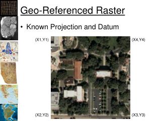
Geo-Referenced Raster • Known Projection and Datum (X1,Y1) (X4,Y4) (X2,Y2) (X3,Y3)
Geo-Referenced Raster • Known Projection and Datum • Width and height of a pixel in map units (X1,Y1) Height in pixels Width in Pixels
Geo-Referenced Raster • Known Projection and Datum (X1,Y1) (X3,Y3)
Continuous vs. Categorized • Continuous: • Like photographs • Satellite and aerial photos • Best for analysis • Categorized or discrete • Land Cover • Eco-regions • Limited analysis • Careful on precision and accuracy
“No-Data” or NULL Values • Rasters are always rectangular • No-Data values are “transparent” and are not used for calcualations
GeoReferenced File Formats • GRID: ESRI’s format • GeoTIFF: Excellent support • MrSID: LizardTech • IMG: ERDAS • ECW: ERMapper • BIL, BIP, BSQ: See header • “ASCII” or “GRID ASCII” (asc)
World Files • Contains: • X-dimention Pixel size in map units • Y-axis rotation • X-axis rotation • Y- dimension Pixel size in map units (negative) • X-coordinate of upper-left pixel • Y-coordinate of upper-left pixel • Image file contains width and height
Tagged Image File Format • TIFF • Can be georeferenced (GeoTIFF) • Can tell in ArcCatalog or ArcMap • TIFF w/world file • Also need Projection and Datum (prj?) • Can be compressed • Run-length – Categorical data • LZW – Categorical data • Huffman encoding – Categorical data • JPEG- Continuous data (don’t used on Categorical data!)
JPEG • Joint Photographic Experts Group • Widest used photo format • JPEG2000 • Completely new format! • Can be georeferenced
GRIDS • ESRI’s native raster format • Pyramids • Not an exchange format!
IMG – ERDAS Imagine • Esri’s new default • Internal geo-referencing • Recommended over Grids
ASCII format (asc) • NCOLS 10 • NROWS 9 • XLLCORNER 1000 • YLLCORNER 1000 • CELLSIZE 1 • NODATA_VALUE -9 • -9 -9 1 1 0 1 0 1 -9 -9 • -9 -9 1 1 2 2 2 1 1 -9 • -9 1 1 1 2 2 2 2 3 3 • Etc.
Types of Rasters • Digital Elevation Model (DEM) • Digital Raster Graphic (Topos) • Satellite and Aerial Photos • Land Cover & other natural characteristics • Cost Distance & other economic • Population, taxes, etc. • Your own!
Derived Rasters Land Cover from satellite and aerial Topography: Slope, aspect, hillshade Ecoregions Suitable Habitat Flood plains Geological Regions