Raster
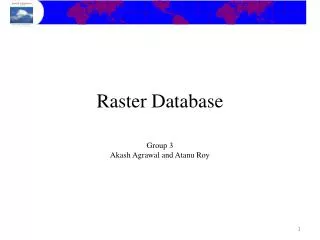
Python Geoprocessing Outside the ESRI Box. Raster. GDAL. Derived data. Vector. Python. OGR. -Microsoft ADO -others. Relational DB. Why Use non-ESRI libraries?. Large performance gains for some operations – more scalable Greater flexibility, if willing to program Full customization


Raster
E N D
Presentation Transcript
Python Geoprocessing Outside the ESRI Box Raster GDAL Deriveddata Vector Python OGR -Microsoft ADO -others Relational DB
Why Use non-ESRI libraries? • Large performance gains for some operations – more scalable • Greater flexibility, if willing to program • Full customization • Large number formats/data sources supported • Open source
GDAL – Geospatial Data Abstraction Library • www.gdal.org • Used in several major software packages • Installation – FWtools Windows binary • Includes a Python instance • Many formats supported: • Arc GRID, SDE raster, Erdas Imagine, GeoTiff, NetCDF, GRASS, several others • Command-line utilities:gdalinfo, gdal_translate, gdal_merge.py, gdal_rasterize • Call from Python - os.system(command)
Programming with GDAL • Library presents a single abstract data model for supported formats • Classes include: • GDALDriver • GDALDataset • GDALRasterBand • others
Open a Raster Dataset for Reading import gdal from gdalconst import * # open GDAL dataset gdata = gdal.Open(‘e:\\data\\z02_evt.img’, GA_ReadOnly) if gdata is None: print 'could not open the raster' sys.exit(1)
Get Projection, Extent, and Cell Size # projection in OpenGIS WKT format proj = gdata.GetProjection() # extent, cell size xSize = gdata.RasterXSize ySize = gdata.RasterYSize geotr = gdata.GetGeoTransform() if not geotr is None: originX = float(geotr[0]) originY = float(geotr[3]) pixelXSize = abs(float(geotr[1])) pixelYSize = abs(float(geotr[5])) geotr = None
Read the First Row of Pixels into a Numeric Array import Numeric # fetch the first band of the raster band = gdata.GetRasterBand(1) # upper left pixel is 0,0 # read first row into an array row = band.ReadAsArray(0, 0, xSize, 1)
Point Overlay Application • Batches of 120 raster layers Imagine (.img) and Arc GRID • 1,000s to 10,000s points per batch • Several batches per week • Need to support single-pixel, as well as multiple-pixel kernels (e.g., 3x3, 5x5, or irregular kernels) • Need access to the raw pixel values • Need to process batches in minutes, not hours, to support production environment and rapid experimentation
OGR Simple Feature Library • Low-level access to vector data • OGRSpatialReference • OGRCoordinateTransformation • Utility programs include ogr2ogr: • Transform formats • Can write kml
Microsoft ADO • Single abstract data model for nearly all database formats • Proprietary, but built in on Windows • Powerful and easy to use • COM objects – instantiate like GP • mainly Connection, Recordset
Microsoft ADO import win32com.client # Create Connection, Recordset objects cn = win32com.client.Dispatch(r"ADODB .Connection") rs = win32com.client.Dispatch(r"ADODB .Recordset") # Open connection to Access database cn.Open(r'Provider=Microsoft.Jet.OLEDB. 4.0;Data Source=' + path_to_mdb)
Microsoft ADO # Execute SQL directly with Connection # sql = an SQL statement (“SELECT …”) cn.Execute(sql) # Or, open a Recordset rs.Open(sql, cn, 3, 1) # Loop over all records rs.MoveFirst() while not rs.EOF: # do stuff rs.MoveNext() rs.Close()
More resources… ArcUser, April-June 2005 http://www.esri.com/news/arcuser/0405/files/python.pdf
More resources… Python and ADO: http://www.markcarter.me.uk/computing/python/ado.html Python Cookbook: http://aspn.activestate.com/ASPN/Python/Cookbook/
Chris Toney RMRS Missoula Fire Sciences Lab christoney@fs.fed.us