1 / 3
0 likes | 5 Views
Understanding a site's physical characteristics is essential for any project's success, especially<br>when dealing with complex or expansive terrain. A

E N D
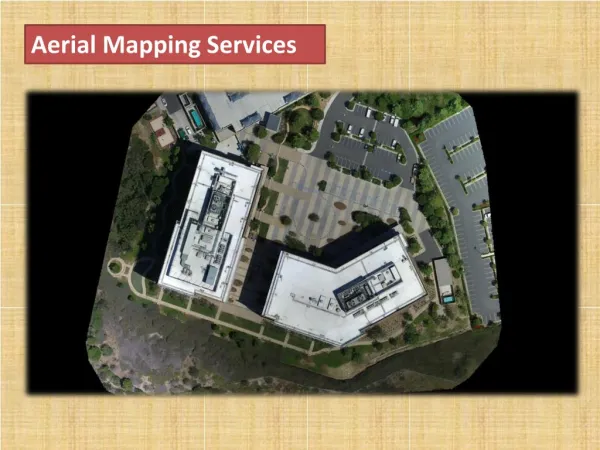
Mapping Complex Terrain With Aerial Topographic Surveys Understanding a site's physical characteristics is essential for any project's success, especially when dealing with complex or expansive terrain. An aerial topographic survey offers an advanced solution for efficiently gathering detailed and accurate land data. By combining cutting-edge technology with precise methods, this type of surveying provides invaluable insights for a variety of industries, from construction to agriculture. How Aerial Topographic Surveys Work At the core of an aerial survey is advanced technology designed to capture precise data from above. High-resolution cameras and LiDAR (Light Detection and Ranging) sensors mounted on drones and other aerial systems capture elevation points and surface details by scanning the terrain. These tools work together to create a highly detailed topographical map of the area. The process typically begins with careful planning to determine the survey's scope and goals. Once the aerial equipment is deployed, data is collected efficiently, even over large or inaccessible areas. The results are then processed using specialized software to create accurate maps and 3D models. These results offer valuable insights into the land's physical features and inform future project planning and execution. The Importance of Mapping Complex Terrain With Aerial Surveys Mapping complex terrain—such as steep slopes, irregular surfaces, or hard-to-access areas—can be a challenge. Aerial surveys provide a fast, accurate, and efficient solution by collecting extensive data, even over large or complex sites. These surveys deliver precise information about land contours, elevation changes, and natural or man-made features. Identifying issues like drainage patterns, unstable slopes, or significant elevation changes early in the planning process helps minimize risks, avoid costly mistakes, and uphold safety standards. Detailed terrain data also allows engineers to design structures that integrate well with the landscape. Key Advantages of Aerial Surveys ● Comprehensive Land Analysis. Aerial surveys provide a detailed understanding of terrain features such as elevation changes, slopes, and natural formations, supporting
smarter planning and effective design decisions. Regulatory Compliance. Precise mapping helps with adherence to zoning, building codes, and safety regulations, reducing potential delays and legal complications during project approval. Resource Efficiency. By identifying challenges early, aerial surveys save time, reduce costs associated with rework, and allow better allocation of resources throughout the project. Improved Safety. Highlighting hazards minimizes risks for construction crews and future users of the site. ● ● ● Industries such as construction, agriculture, and mining rely heavily on aerial surveys to provide critical data quickly and accurately. These surveys help construction teams plan infrastructure, aid farmers in understanding land conditions, and allow mining operations to map resources efficiently. Topographical surveys are indispensable for projects requiring detailed terrain mapping by delivering precise and wide-ranging insights. Aerial Surveys vs. Traditional Surveying Methods Traditional topographical surveys remain effective for many projects, but aerial methods offer unique advantages in specific scenarios. Aerial surveys stand out for their speed and coverage, making them ideal for larger sites or areas with difficult access. Using drones and advanced sensors, aerial surveys achieve high accuracy while capturing data quickly. For instance, instead of deploying multiple ground teams to manually collect elevation data, an aerial survey can gather the same information in less time. Their unique perspective is invaluable for projects needing a complete understanding of the site's topography. However, traditional land surveying remains essential for smaller or highly detailed areas requiring close-range measurements. By combining aerial and ground-based methods, professionals can provide precise and dependable results for a wide variety of projects. Partner With Our Experts in Land Surveying The success of an aerial topographic survey depends on the expertise of the professionals and the technology used. Partnering with a trusted surveying company ensures precision, professionalism, and customized solutions to meet your project's specific needs. Experienced surveyors deliver reliable results, empowering confident decisions and driving project success. At Sisemore & Associates, we bring 30 years of expertise to every project, specializing in a variety of land surveying services and utilizing advanced technology to provide accurate and reliable data.
Contact us today to learn more about our surveying services.