Download
1 / 16
170 likes | 349 Views
6 th Grade Social Studies Chapter 5 Lesson 1 in the World Text. Ancient Mesopotamia- Geography of the Fertile Crescent. The Big Picture. Around 4000 BC Egyptian farming communities were growing along the Nile River. Another civilization was also developing in Western Asia .

E N D
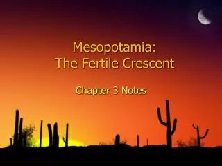
6thGrade Social Studies Chapter 5 Lesson 1 in the World Text Ancient Mesopotamia- Geography of the Fertile Crescent
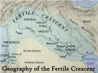
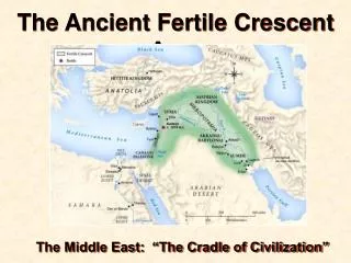
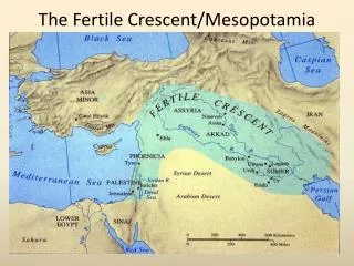
The Big Picture • Around 4000 BC Egyptian farming communities were growing along the Nile River. • Another civilization was also developing in Western Asia. • This area was later called the Fertile Crescent because it looks like a quarter moon. • The Fertile Crescent covers the present-day countries of Iraq, Syria, Lebanon, and Israel.
The Big Picture • Much of the land was either rocky mountains or desert. • The 2 rivers, the Tigris and the Euphrates, made life in these areas possible.
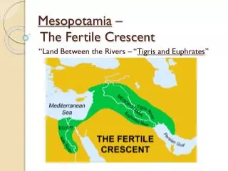
Between 2 Rivers • The region between the Tigris and the Euphrates is known as Mesopotamia. • In Greek it means “land between two rivers.” • This area is now known as Iraq.
Between 2 Rivers-From Mountains to the Sea • Both the Tigris and the Euphrates begin in the Taurus Mountains, located in Turkey. • The rivers rush down and then reach the plateau, located in present-day northern Iraq. • A plateau is an area of elevated flatland. • In southern Iraq the rivers flow to lower land and empty into the Persian Gulf.
Between 2 Rivers-Flood • Early communities in Mesopotamia depended on river deposits of silt. • It made the region a good place for farming. • Mesopotamia’s yearly floods did NOT come as regularly as those in Egypt. • They often came at the wrong time for farmers. • The rivers did not flood during planting season when dry fields needed to be softened and prepared for new growth. • Instead, floods came just as crops were ready to be harvested.
Between 2 Rivers-Flood • Farmers had to protect their fields from flood damage. • They also had to keep them watered in the hot, dry climate. • Southern Mesopotamia rarely received rain. • Droughts, or long periods of dry weather, were a constant threat to farmers and their crops.
Between 2 Rivers-Flood • Northern Mesopotamia usually had enough rain, but the rocky earth had only pockets of fertile soil. • The flooding rivers did NOT leave behind as much silt in the north. • Which area (Northern or Southern Mesopotamia) had more fertile land? Explain. • Southern Mesopotamia b/c there was more silt in the south.
From River to Field • In the Fall farmers of southern Mesopotamia needed water to plant and raise new crops. • Unfortunately, Fall was the time when the Tigris and Euphrates rivers were at their lowest. Mesopotamia- Tigris River
From River to Field • Spring was harvest time; however, it was also the time the rivers flooded. • The time the rivers flooded was such a problem because it happened during the harvest. • The perfect time would be the Fall since this is when they were planting the crops and the fields were dry. • To solve these difficulties, ancient farmers learned to build water-control and irrigation systems.
From River to Field-Farming in Ancient Mesopotamia • Early farmers grew many different crops. • The areas MOST important crops were wheat and barley. • Other crops included: beans, onions, lettuce, cucumbers, spice plants, date palm, apple and pomegranate trees.
From River to Field-Farming in Ancient Mesopotamia • Mesopotamian farmers planted their crops and trees along canal banks. • On the edges of village farmland, you might see shepherds caring for sheep and goats. • Sheep were especially prized for their milk and wool.
From River to Field-Farming in Ancient Mesopotamia • Ancient Mesopotamians also valued cattle because they were good work animals and were used for milk, leather, and meat.
Why it Matters? • Water and soil brought by the Tigris and Euphrates helped to make this civilization possible. • The farmers figured out how to use the two rivers to make the land more fertile. • As in some early cultures, the farmers of Mesopotamia produced surplus crops. • These surpluses allowed for specialization, which in turn led to the growth of towns and cities.
Main Ideas • Mesopotamia is the region between the Tigris and Euphrates Rivers. • It is divided into a rugged plateau to the north and fertile plains to the south. • Like the Nile River, the Tigris and Euphrates flood each year. • These floods brought water and silt to Mesopotamia.
Main Ideas • Unlike those in Egypt, floods in Mesopotamia were often destructive and badly timed for farmers. • Mesopotamian farmers used canal systems to control dangerous flooding, making their land productive.