Download
1 / 25
250 likes | 266 Views
EUNIS and EUSeaMap: Towards common spatial seabed data for the Baltic. David Connor, JNCC, UK HELCOM Red List habitat workshop, 25-26 March 2010, Stockholm. Introduction. Policy context – MSFD, MPAs, MSP EUNIS context: past considerations EMODNet & EUSeaMap objectives

E N D
EUNIS and EUSeaMap: Towards common spatial seabed data for the Baltic David Connor, JNCC, UK HELCOM Red List habitat workshop, 25-26 March 2010, Stockholm
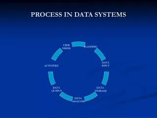
Introduction • Policy context – MSFD, MPAs, MSP • EUNIS context: past considerations • EMODNet & EUSeaMap objectives • Habitat modelling and data layers • Potential to validate and update EUNIS • Summary
Why map the seabed? Effective management of the marine environment requires information on the spatial distribution and the quality of seabed habitats
Broad-scale seabed maps can… • Contribute to quality assessments • Regional conventions e.g. HELCOM Status Reporting • EU Marine Strategy Framework Directive • Support Marine Protected Area designation • EC Habitats, Birds & Marine Strategy Framework Directives • Regional conventions e.g. HELCOM MPAs • National programmes • Contribute to Marine Spatial Planning • EU Integrated Maritime Policy • National initiatives Background EUSeaMap Objectives Project Details Methods Progress Summary
Spatial habitat data for MSFD • Article 8 – initial assessment 2012 “Member States shall make an initial assessment of their marine waters, taking account of existing data where available and comprising … an analysis of the essential features and characteristics … covering the physical and chemical features, the habitat types, the biological features and the hydro-morphology” • Annex III – habitat elements of assessments “thepredominant seabed and water column habitat type(s) with a description of the characteristic physical and chemical features, such as depth, water temperature regime, currents and other water movements, salinity, structure and substrata composition of the seabed” “identification and mapping of special habitat types, especially those recognised or identified under Community legislation (the Habitats Directive and the Birds Directive) or international conventions as being of special scientific or biodiversity interest” EUSeaMap HELCOM Red List, Habitats Directive Background EUSeaMap Objectives Project Details Methods Progress Summary
EUNIS in the Baltic • Current EUNIS classification reflects last HELCOM red list (1998) • Not comprehensive, limited biology, structure not fully compatible with rest of EUNIS Marine • Progress in recent years to update and improve: • Workshop in March 2008 • Proposed restructuring of upper levels in EUNIS • Complimentary work at community level in number of projects and countries • Aimed to further develop with HELCOM support
March 2008 – Parameters/classes • Substrate • Hard – Rock (inc. clay, till), Biogenic • Soft – Gravel/coarse sand, Sand, Mud, Mixed, Vegetated sediments • Salinity • Variable (30-18ppt – Kattegat) • Reduced (18-7.5, 7.5-4, 4-0.5) • Zone/depth • Littoral (hydrolittoral), Infralittoral, Circalittoral, Deep circalittoral • Other factors: Ice, Deoxygenated habitats
EMODNet • EC DG-MARE initiative • Supports EU Integrated Maritime Policy • Preparatory phase – 2009-2011: • Hydrography • Geology • Chemistry • Biology • Seabed habitat maps - EUSeaMap • Deliver harmonised datasets for selected regional seas • Web-portal dissemination – interoperable data
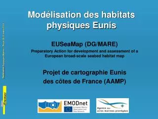
EUSeaMap aim To provide broad-scale maps of seabed habitats, using common functional mapping methods, for the Baltic Sea Greater North Sea Celtic Seas and Western Mediterranean and to determine what further steps are required to improve their usefulness and coverage Background EUSeaMap Objectives Project Details Methods Progress Summary
Preparatory Action for development and assessment of a European broad-scale seabed habitat map Background EUSeaMap Objectives Project Details Methods Progress Summary
EUSeaMap partners Background EUSeaMap Objectives Project Details Methods Progress Summary
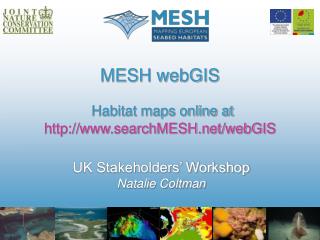
Previous broadscale mapping • MESH • INTERREG IIIB-funded • Covered north-west Europe • Produced EUNIS map • BALANCE • INTERREG IIIB-funded • Covered Baltic sea region • Produced marine landscape map MESH broadscale EUNIS map Background EUSeaMap Objectives Project Details Methods Progress Summary
Modelling approach e.g. Depth e.g. Seabed salinity e.g. Sediment type Biologically relevant? Represented in EUNIS? Combination A Combination B Background EUSeaMap Objectives Project Details Methods Results Summary
Example:Baltic Sea marine habitat modelling • Primary data sets: • Sediments www.searchMESH.net
Example:Baltic Sea marine habitat modelling • Primary data sets: • Sediments • Benthic salinity www.searchMESH.net
Example:Baltic Sea marine habitat modelling • Primary data sets: • Sediments • Benthic salinity • Photic zone www.searchMESH.net
Sweden Denmark Poland Germany Non-photic mud, >30psu Balance broad-scale habitat map Non-photic sand, 11-18psu
Physical input data layers Background EUSeaMap Objectives Project Details Methods Progress Summary
Ecologically relevant thresholds Background EUSeaMap Objectives Project Details Methods Progress Summary
Data preparation progress • Sediment: EMODNET Background EUSeaMap Objectives Project Details Methods Progress Summary
Data preparation progress • Sediment: EMODNET, data collation in W Med • Bathymetry: EMODNET, improvements to BALANCE outputs • Light: 1km MERIS data, improvements to BALANCE Secchi disc data, thresholds Background EUSeaMap Objectives Project Details Methods Progress Summary
Light Background EUSeaMap Objectives Project Details Methods Progress Summary
EUNIS & EUSeaMap- Potential links • EUSeaMap • Provide broad-scale coverage for Baltic • Build upon BALANCE – similar scale of output • Improved data layers and modelling • Biological validation of thresholds in physical data • Leads to EUNIS-compatible habitat classes and map • EUNIS level 2-4 – new structure/classes • Biological analyses within HELCOM frame • Consistent biotopes/community types for Baltic • EUNIS levels 4-6 • Further validate EUSeaMap • EUSeaMap + HELCOM = Baltic proposal for EUNIS
Summary Common seabed data for Europe are emerging These data will contribute to initial assessments for MSFD EUSeaMap and HELCOM biotope work can lead to proposals for EUNIS classification
Find out more… EC website http://ec.europa.eu/maritimeaffairs/emodnet/ preparatory/home.html JNCC website www.jncc.gov.uk/EUSeaMap Get in touch natalie.coltman@jncc.gov.uk Background EUSeaMap Objectives Project Details Methods Progress Summary