Download
1 / 1
20 likes | 178 Views
The Neutrally Buoyant Sediment Trap A new tool for “Twilight Zone” exploration James Valdes and Ken Buesseler, Woods Hole Oceanographic Institution Paper Number OS26A-10.

E N D
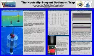
The Neutrally Buoyant Sediment Trap A new tool for “Twilight Zone” exploration James Valdes and Ken Buesseler, Woods Hole Oceanographic Institution Paper Number OS26A-10 LOGO NBST BALLAST CONSIDERATIONS _ WORKSHEET NBST - A NEW WAY TO CATCH THE RAIN INTRODUCTION DEPTH RECORDS, 150, 300, 500 dB – HOTS & K2 We have recently developed and deployed for the first time in support of a major field experiment (VERTIGO) an improved sediment trap that is designed around a neutrally buoyant float (1). Since ocean particles sink slowly (10's-100's m/day) relative to ocean currents (km/day) it becomes extremely difficult to collect particles from a fixed or slowly moving platform. The NBST drifts with the currents, thus eliminating most of the hydrodynamic effects which can lead to particle sorting and flux biases. Our NBST opens up a new window to study more accurately the rain of particles out of the upper ocean, in the ocean’s “twilight zone”. The NBST is autonomous, it incorporates a dedicated controller (u-processor) which oversees all aspects of the mission from the deployment to the recovery. Over the term of it’s deployment (3 - 5 days nom.) the instrument actively monitors it’s depth and adjusts it’s displacement to maintain the pre-programmed depth, +/- 10 dB. At the conclusion of the mission a motorized pin is retracted closing the covers on the PITS style sample tubes prior to it’s returning to the surface. Once on the surface a suite of recovery aids facilitates it’s relocation and recovery. Instrument ballasting is crucial to the success of the mission. The hull assembly is weighed under pressure to determine it’s buoyancy and compressibility. All of the external components, including the brine solution, must be characterized when calculating the weight to be added to send to instrument to the desired depth. There are 5 polycarbonate sample tubes per instrument (4.75 id x 23.0 Inches) with an approximate 5:1 aspect ratio. These incorporate an internal baffle and a “Clap Trap” closure mechanism. Night recoveries – with a known GPS position and the flasher -were nearly routine. Most instruments were recovered within an hour of their reaching the surface. We were able to monitor the satellite uplink transmission with a shipboard RDF. Once within range, a nominal 5 – 8 miles, we could decode the embedded GPS position to quickly close on the instrument at the surface. NBST– II In order to accurately set the operating depth the instruments overall mass, displacement and compressibility must be quantified. A worksheet was developed which details the necessary weight to be added for the various depths and trap assemblies for each instrument and deployment. Trim weights (washers) are added externally to facilitate ballast adjustments at sea. The addition of a single 1/2 inch washer is equivalent to approximately 50 meters depth change in the ocean. ` Depth records from deployments at HOTS and K2 are shown above. Note that in all cases the instruments settled at the intended depths. The NBST took no corrective action if within +/- 10 dB of the programmed depth. The K2 deployments utilized a modified launch algorithm which resulted in a larger overshoot at deployment in an effort to reach the neutral depth in a shorter period of time. The ballast was adjusted on the 500 meter K2 instrument to minimize the launch transient. RECOVERY AIDS The NBST exhibits a small surface profile. Incorporated into the design of the NBST are a number of recovery aids. • Argos / GPS relocation beacon - A single antenna functions for both Argos and GPS, position data are embedded in the data stream of the Argos satellite transmitter. • LED Flasher – this low power flasher is visible at up to 3 miles under ideal conditions. • Painted top cap – enhances visibility during daytime recovery. CONCLUSIONS, OBSERVATIONS and RECOMMENDATIONS • The NBST has proven to be a cost effective, practical and reliable means of sampling particle flux in the twilight zone, there have been no instrument losses in the last 33 deployments. • Multiple deployments at a single depth during K2 resulted in the NBSTs (3 ea.) surfacing within 100 meters of each other after 3+ days at depth ! These were several miles from the surface tethered PITs arrays. • Additional deployments should be made under a variety of sea states and particle flux conditions to quantify the collection characteristics of the NBST. NBST illuminated by ship’s spotlight at recovery. ADD PICTURE OF ENDCAP HERE End cap picture here 1. Profiling ALACEs and Other Advances in Autonomous Subsurface Floats,Davis et all Journal of Atmospheric and Oceanic technology:Vol.18,No.6,pp.982-983