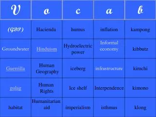
DPI groundwater database
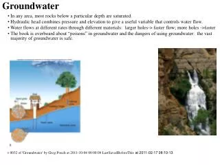
This document presents an in-depth analysis of groundwater bore characteristics, focusing on Bore 1 with a diameter of 125mm and specific aquifer properties. Key parameters include bore maintenance case height (0.29m), screen intervals (9m to 12m), and various lithological data. Groundwater levels are examined, showing significant measurement points from August 1986, with depths indicating both saturated and partly saturated aquifer conditions. The effects of casing and screen construction on water flow are also discussed, providing a comprehensive overview for groundwater assessments.

DPI groundwater database
E N D
Presentation Transcript
DPI groundwater database Diagrams and examples
dbo_bore_maint:diameter *(125mm) Bore 1 dbo_bore_survey_new:rltop *(199.825mASL) dbo_bore_maint:case_height *(0.29m) dbo_bore_survey_new:rlns *(199.535mASL) Lithology 1 dbo_bores:bdepth *(78m) dbo_bore_maint:screen_from *(9m) Lithology 2 dbo_bore_maint:screen_to *(12m) Boreconstruction
Bore 1 Bore with casing and screen construction Aquitard – inhibiting water flow Groundwater level dependant on pressure within aquifer dbo_aquifer:from_depth *(9m) Saturated Aquifer – allowing water flow dbo_aquifer:to_depth *(12m) Groundwater
Bore 1 dbo_bore_maint:case_height *(0.29m) dbo_water_levels:depth *(1986-08-06, 4.2m) dbo_bore_survey_new:rlns *(199.535mASL) dbo_water_levels:natsurf *(1986-08-06, 3.91m) dbo_water_levels:reduced_level *(1986-08-06, 195.625mASL) Water measurements Red value is the only water level measure taken at the bore.
Example Bore 2541 dbo_bore_maint:case_height (0.25m) dbo_water_levels:depth (1995-03-27, 15.18m) dbo_bores:bdepth (16.5m) dbo_aquifer:from_depth (13m) dbo_bore_maint:screen_from (14m) Partly saturated aquifer dbo_bore_maint:screen_to (16m) dbo_aquifer:to_depth (16.5m) Aquifer with lower water level