National Land Parcel ( NLP) Commercial Perspective
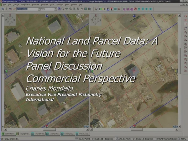
National Land Parcel Data: A Vision for the Future Panel Discussion Commercial Perspective Charles Mondello Executive Vice President Pictometry International. National Land Parcel ( NLP) Commercial Perspective.

National Land Parcel ( NLP) Commercial Perspective
E N D
Presentation Transcript
National Land Parcel Data: A Vision for the FuturePanel DiscussionCommercial PerspectiveCharles MondelloExecutive Vice President PictometryInternational
National Land Parcel (NLP) Commercial Perspective • LP data drives many key market segments that benefit the needs of the public and private sectors • As a commercial data supplier access to LP data: • Enables data visualization • Reduces field work • Save lives • Generates revenue for ALL sectors
Dozens of client markets benefit from LP data layered with vector and raster products • Emergency / Public Safety • Law Enforcement • Residential, Commercial, Industrial, Community Development • Assessment, Appraisal, Real Property Information and Management • Census Data • Environmental Management and Assessment • Planning, Zoning and Building Departments • Preplanning and Post Assessment for Civil Defense or Disaster Planning Mapping and GIS Information Integration and Data Population • Highway Assessment and Management • Parks and Recreation • Public Works • Facilities Management • Forestry • Historical Archiving (legal, environmental, etc.) • Public Relations and Tourism • Transportation
Comments will center around the following recommendations • From NLP a Vision for the Future: • Recommendations 2-4 • Recommendations 6-9
Based on A lets hope we have no emergency here NLP RECOMMENDATION • RECOMMENDATION 2. As part of the Geospatial Line of Business process, the FGDC should identify the role of parcel datain the collection and maintenance of the following data themes: Buildings and Facilities, Cultural Resources, Governmental Units, and Housing. • RECOMMENDATION 3. The Federal Land Parcel Coordinator should coordinate the development and maintenance of a single, comprehensive, and authoritative geographically referenced data base for land parcels managed by the federal government, including public lands. This database should include the ownership, area, and use of all federally managed lands. • RECOMMENDATION 4. The National Land Parcel Coordinator should develop and oversee a land parcel data business plan for the nation. This plan should serve as the basis for evaluation of the program and as a model for state and local governments. Metrics should be based on the FGDC Parcel Management Program Business Plan Template. • Comment • The availability of NLP address centroid could : • dramatically drive incremental revenue for all levels of government • improve emergency 911 systems across the nation • provide a starting point for parcel data in rural parts of the country • Many of these benefits already exist in more affluent regions • IN EXAMPLE>>>
Where do we draw the line on data confidentiality? Do we allow access to only: Taxation Emergency response What about: Flood Insurance AVL If confidentiality is enacted what services do consumers lose from Data already available at many online mapping sites NLP Recommendation • RECOMMENDATION 6. Congress and the Bureau of the Census should explore potential policy options, including modifications to Title 13, that would allow its digital data on building addresses and their geographical coordinates to be placed in the public domain while also maintaining important privacy protections. If publicly available, these street addresses and coordinates could be used to assist in the development of parcel data in areas where parcel data sets do not exist. Comment:Data must be accessible by the private sector to develop products that support the needs of all levels of users.
If we review the Galveston Example The NLP program should consider more than simple ROI NLP must develop a role out plan based on data type Uses and Needs of Cadastral Data by Federal Agencies Uses and Needs of Cadastral Data by Federal Agencies Appendix B FGDC Cadastral Data Subcommittee July 2008 Pg 12
Points of Concern from others polled: Recommendation 9 Comment “If the program does not allow counties access to ortho imagery from the state because they do not have the parcel data to give, how can they generate the parcels to participate....” Recommendation 7 Comment “Sounds like an unfunded mandate? I agree with the position of the committee but adding a person or adding (significantly) to a persons workload could be challenging. Many rural counties don’t have the staff or technology to fulfill the task”