Download

1 / 27
290 likes | 579 Views
Marking of Land Parcel Boundaries. Kazys Maksvytis Head of the Real Property Cadastre and Register Department of the State Enterprise Centre of Registers E-mail: Kazys.Maksvytis@registrucentras.lt. MAIN LEGAL ACTS. Law on Land Law on Real Property Cadastre

E N D
Marking of Land Parcel Boundaries Kazys Maksvytis Head of the Real Property Cadastre and Register Department of the State Enterprise Centre of Registers E-mail: Kazys.Maksvytis@registrucentras.lt
MAIN LEGAL ACTS • Law on Land • Law on Real Property Cadastre • Code of Administrative Offences of the Republic of Lithuania • Civil Code of the Republic of Lithuania • Regulations of Real Property Cadastre • Standards of boundary marks and rules for marking of land parcel boundaries
TERMS AND DEFINITIONS • Boundary of a land parcel means the boundary between land parcels marked by boundary marks on site or coinciding with stable elements of the landscape and graphically marked on the plan of a land parcel. • Boundary mark means a mark establishing the boundaries of a land parcel in the area and complying with a standard set by the National Land Service authorised by the Government and legally protected in accordance with the procedure laid down in legal acts.
BOUNDARIES OF LAND PARCELS ARE NOT MARKED BY BOUNDARY MARKS • Where the boundary of a land parcel coincides with artificial or natural objects (row of trees, hedge, solid fence, ditch and similar) • Goes along the water bodies (sea, lake, pond, river, stream, drainage ditch) • When land parcels are formed for the maintenance of roads, rails • When land parcels are formed for the maintenance of the water bodies of the state significance
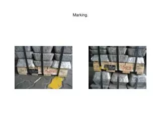
TYPES AND STANDARDS OF BOUNDARY MARKS • Reinforced concrete • Plastic • Metal • Boundary marks for solid ground • Wooden till 2005
CONTRACT BETWEEN CLIENT AND SURVEYOR • Basis for cadastral surveying is the contract between a client and a surveyor unless otherwise provided by laws or any legal acts. • Contract shall indicate: • conditions for marking of boundaries, conditions for placement of boundary marks: • who undertakes to fix/dig in the boundary marks into the ground and to cover them with earth; • who undertakes to do a cutting of 0.5 m for better visibility. • Types of boundary marks and conditions for their production or procurement.
PREPARATORY WORKS (1) • PREPARATORY WORKS IN THE OFFICE : • Collection of geodetic and mapping material: • Plans and sketches of a land parcel; • Certificate about the owners of adjacent land parcels; • Excerpt from the cadastral map; • Acts on marking-witnessing the boundaries. • The following is identified having analysed the geodetic and mapping material: • Persons to be invited, • Quantity of vertex points of a boundary and preliminary quantity of boundary marks, • Ratio of lengths of land parcel boundary lines on the sketch, land parcel plan, territorial planning document when a land parcel registered in the Real Property Register must be marked; • Information presented on the plans, sketches and other documents of adjacent land parcels is evaluated.
PREPARATORY WORKS (2) • PREPARATORY WORKS IN THE FIELD: • If a land parcel is registered in the Real Property Register the following is established: • whether the location for installation of the existing boundary marks of the subject land parcel, land parcel boundaries in use, lengths of lines between vertex points corresponds to the territorial planning document, sketch and land parcel plan; • quantity of boundary marks to be installed. • If a land parcel is not registered in the Real Property Register the following is established: • whether the location for installation of boundary marks of the adjacent land parcels corresponds to the territorial planning document, sketches and land parcel plans; • quantity of boundary marks to be installed. • Identification of persons to be invited to the marking.
OWNERS OF THE ADJACENT LAND PARCELS ARE NOT INVITED TO THE MARKING IF : • Coordinates of adjacent land parcels’ vertex points and boundary marks are established in the state coordinate system; • There are existing boundary marks; • Common boundary coincides; • Boundary of the subject land parcel goes along the middle of a hydrographical object (stream, drainage ditch or similar).
MARKING Main requirements: • Boundary marks are used to mark the land parcel boundaries on the inland; • Boundary marks are installed on the vertex points of the land parcel boundaries; • In case of a straight boundary line the boundary marks are installed within a distance allowing their visibility but not more than 500 meters from each other; • Boundaries of the land parcels possessed by other land owners, users or the State and which are inside the boundaries of the subject land parcel are marked; • Forestry parcel is marked by cutting a strip of 0.5 m width to guarantee visibility between the boundary marks;
ACT ON MARKING-WITNESSING THE LAND PARCEL BOUNDARIES • Act on marking-witnessing the land parcel boundaries describes the following: • Boundary marks fixed earlier and now used to mark the land parcel boundaries; • Restored boundary marks; • Newly installed boundary marks; • Temporary boundary marks replaced by permanent ones; • Boundaries coinciding with natural and artificial objects; • Length of cuttings.
WHO MUST SIGN THE ACT ON MARKING-WITNESSING OF LAND PARCEL BOUNDARIES? • Land parcel owner/owners • Persons invited (owners of adjacent land parcels) • Surveyor • Responsibility for demolition or damage of boundary marks.
TAKING PHOTOS OF BOUNDARY MARKS • Purpose of taking a photo is to record visual situation of the subject land parcel boundaries on site. • A photo is taken in case of: • a dispute among the participants of the process; • a wish expressed by at least one of the participants of the process; • boundary marks of previously marked land parcel boundaries’ vertex points are restored which have been destroyed.
DECISIONS OF SURVEYORS • Decisions of a surveyor: • To reviseland parcel boundaries on the ground; • Do not revise land parcel boundaries on the ground. • Surveyor takes a decision having received remarks in writing from the persons invited. • Cadastral surveys are not suspended due to the remarks submitted. • Surveyor notifies in writing the persons who have been invited and submitted written remarks on the decision taken and provides grounds on the decision taken. • Surveyor’s decision may be appealed to the court.
SETTLEMENT OF DISPUTES ON BOUNDARIES • Territorial planning documents; • Documents of cadastral data files of land parcels: • Plans, • Sketches, • Acts on boundary marking-witnessing. • Vertex points of the boundary marked on the ground with boundary marks.
COURT PRACTICE • Courts investigate disputes regarding the boundaries of land parcels in cases: • The owners of land parcels do not agree on the disputed parcel boundaries and • The boundaries are not clear with reference to the existing documents. • The court establishes boundaries taking into account: • Documents, • Boundaries of actually possessed parcels, and • Other evidences. • In case it is impossible to set the boundaries, each land parcel should be attached a part of a disputed land area of equal size; however none of the parcels formed in such a way should differ in area from the existing legally approved parcel.
FACTORS INFLUENCING BOUNDARY MARKS • Natural factors: • Humidity, • Sun, • Frost. • Human factors: • Farming activities, • Road maintenance works, • Criminal offence.
RESPONSIBILITY • Code of Administrative Offences: • Destruction or damage made to the permanent boundary marks of lands – a fine from 250 litas up to 500 litas; • Deviation from the land management plan approved in the established manner without a proper permit - a fine from 50 litas up to 100 litas.
STATISTICS • Real Property Register contains 2.143.739 registered land parcels (at least 9-10 million boundary vertexes)
CONCLUSIONS • To ensure high quality of determining the coordinates of land parcel vertexes. • To improve standards of boundary marks. • There is a need to consider renovation of boundary marks in legal acts. • A surveyor should undertake full responsibility for a proper marking of land parcels and taking relevant decisions.
QUESTIONS • Is it relevant to store information on the condition of boundary marks in the registers? (date of installation, restoration, renewal; standard (wooden, reinforced concrete, etc.)). • Is it relevant to take photos of boundary marks?
Thank you for your attention Kazys.Maksvytis@registrucentras.lt