Download
1 / 20
200 likes | 232 Views
This project aims to connect research instrumentation data with geographic features of TWDEF in a GIS for optimal mapping and information visualization. Data collection includes topographic and infrastructure details. Map creation and export to Google Earth are key components.

E N D
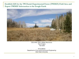
Establish GIS for the TW Daniel Experimental Forest (TWDEF) Field Area and Export TWDEF Information to the Google Earth CEE 6440, GIS in Water Resources Term Project Fall 2006 Vinod Mahat Department of Civil and Environment Engineering Utah State University
Introduction Motivation • TWDEF area has been research site for many researchers • Substantial investement in research instruments • My research site Objective • To establish a connection of all the information regarding instrumentations with available data and topographical and geographical feature of the TWFDEF area to the geographical information system. Plans • Data Collection • Collection of the information regarding the infrastructures, instrumentation and other important information • Delineation of the extent of the TWDEF area • Preparation of the site, location and regional map for the TWDEF • Export into into the Google earth.
Introduction Location: • TWDaniel Experimental Forest • Utah (41.860N, 111.500W) • 30km N-E of Logan • 2600m elevation • 0.25 km2 area Climatic condition • Av. annual Prep.= 950mm(80% snow) • Av. monthly low temp.= -100c • Av.monthly high temp.= 14.50c • Forest= Aspen and Conifer • Non Forest= Open midow with • grasses ,sagebrush
Data Collection Data collected from Internet • DEM • National Hydrography data set • Orthographic map • Topographic map • Access information (Road) • County’s boundaries Data collected from Other sources • GPS data for the position of the instruments • Data for the boundary of the area • GPS data for the road inside the boundary • Data of the cables • GPS data for the position of the other structures e.g. cabin, old precipitation station etc. • Hydrological data
Linking to the Google Earth All the information (maps, hydrological data) http://Ceefs2.cee.usu.edu/giswr/mahat Create a Point shape file for TWDEF and export it into the Google Earth (TWDEFSITE.kml) Link : Location of the TWDEF Site
Linking to the Google Earth p> <img width =528 height=408 src="http://Ceefs2.cee.usu.edu/giswr/mahat/sitemap.jpg"</p><p></p> <a href=http://Ceefs2.cee.usu.edu/giswr/mahat/cable map.jpg>cable map</a> <a href=http://Ceefs2.cee.usu.edu/giswr/mahat/Location.jpg>Location map</a> <a href="http://ceefs2.cee.usu.edu/giswr/mahat/Weather Instrument.jpg">Weather Station</a> <a href=http://Ceefs2.cee.usu.edu/giswr/mahat/Aspen-2.xls>weather data</a> <a href=http://Ceefs2.cee.usu.edu/giswr/mahat/DSC02142.jpg>Site Photo3</a> <a href=http://Ceefs2.cee.usu.edu/giswr/mahat/DSC02158.jpg>Site Photo4</a> Links : Data information
Linking to the Google Earth p> <img width =528 height=408 src="http://Ceefs2.cee.usu.edu/giswr/mahat/sitemap.jpg"</p><p></p>
Linking to the Google Earth <a href=http://Ceefs2.cee.usu.edu/giswr/mahat/sitemap2.jpg>sitemap2</a> <a href=http://Ceefs2.cee.usu.edu/giswr/mahat/locationmap.jpg>Location Map</a> <a href=http://Ceefs2.cee.usu.edu/giswr/mahat/DSC02135.jpg>Site Photo1</a> <a href=http://Ceefs2.cee.usu.edu/giswr/mahat/DSC02141.jpg>Site Photo2</a> <a href=http://Ceefs2.cee.usu.edu/giswr/mahat/DSC02142.jpg>Site Photo3</a> <a href=http://Ceefs2.cee.usu.edu/giswr/mahat/DSC02158.jpg>Site Photo4</a>
Linking to the Google Earth Preparing a map creating the new line feature classcreate new line feature class in in Arc CatalogOpen up in in arc mapadd all values of coordinates in the mapstart editing select task create new feature and target new line, and using the drawing pencil draw the over the respective co ordinates.Convert into the shape fileExport into the Google EarthLink: : TWDEF MAP
Linking to the Google Earth Link: TWDEF MAP