Download
1 / 17
170 likes | 189 Views
Learn about geoscience resources and social data used for diamond mining assessments in Central and Western Africa. Explore fieldwork, GIS technologies, and remote sensing applications for monitoring activities.

E N D
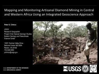
Mapping and Monitoring Artisanal Diamond Mining in Central and Western Africa Using an Integrated Geoscience Approach Peter G. Chirico USGS Research Geographer Project Chief, Special Geologic Studies Eastern Geology and Paleoclimate Science Center 12201 Sunrise Valley Drive National Center MS 926A Reston, VA 20192 703-648-6950 pchirico@usgs.gov U.S. DEPARTMENT OF THE INTERIOR U.S. GEOLOGICAL SURVEY
USGS TECHNICAL ASSISTANCE • The Kimberley Process (KP) • The Clean Diamond Trade Act of 2003 • The U.S. Department of State’s Special Advisor for Conflict Diamonds • USAID PRADD Program Fieldwork at ASM sites in Guinea, 2012 An official KP Certificate accompanying a diamond shipment from CAR
RESOURCE AND PRODUCTION CAPACITY ASSESSMENTS • To conduct alluvial diamond resource assessments, an integrated approach has been developed comprised of three essential components: • Geologic and geomorphic data • Grade (carats/m³), gravel thickness, overburden material and thickness, bedrock material, geomorphic zone, etc. • Social and human geographic data • The number of miners, the roles of men, women, and children, tools used, number of days worked per year, seasonality of mining, reasons for mining, etc. • GIS and remote sensing technologies • Used to model the hydrography and geomorphology, identify and characterize pits, and monitor mining activities. Resource Assessments Mali: 2006-2009 CAR 2006-2009 Ghana: 2009-2010 Guinea: 2010-2012 Cote d’Ivoire: 2007-present Other project activities Liberia Zimbabwe Map showing assessment locations
PURPOSE • It was necessary to develop a methodology for conducting regional and country scale assessments • A methodology was first developed by Barthélémy and others (2006) in an assessment of Congo-Brazzaville • This methodology has since been modified by Chirico and others (2010, 2012) • This methodology provides a means of independently verifying a country’s reported diamond production statistics • Assessment results are compared to the production statistics released to the KP • Areas falling far outside the estimated range are identified as areas of concern Graph showing alluvial, primary, and total production for Seguela, Côte d’Ivoire from 2006-2012 Chart showing production for Seguela and Tortiya, Côte d’Ivoire, from 2006-2012
FIELD WORK Collection of social and humangeographic data through group interviews Comprehensive questionnaire used for data collection
FIELD WORK Site characterization: Collection of geologic and geomorphic data through measurement, sampling, and observation Artisanal mine pit with profile, Heremakono, Guinea A researcher collecting data in Guinea Artisanal mine pit with profile, Fondiya, Guinea
GEOMORPHIC MODELING • Deposit richness is closely related to local geomorphology • A model is developed for the study area characterizing the geomorphic units
PRELIMINARY SATELLITE IMAGERY ANALYSIS Satellite imagery can be used to identify active vs. inactive mine sites, thus providing information on the level of activity and identifying locations for field visits 01/08/2010 New mining by artisans Fieldwork 03/06/2012 01/30/2011 01/30/2011 Changes at a site over time, Bouramaya, Guinea
SATELLITE IMAGERY ANALYSIS FOR LONG-TERM MONITORING casey’s 3D
TIME SERIES ANALYSIS OF ACTIVE PITS IN THE SEGUELA REGION, COTE D’IVOIRE Graph showing alluvial, primary, and total production for Seguela, Côte d’Ivoire from 2006-2012
CAR Monitoring: Sam Ouandja terrace mining and washing site Mining camp expands to a site measuring 180 m x 95 m. Over 65 active pits identified. New mining camp established Dec. 26, 2012 Satellite Image Credit: DigitalGlobe, Inc., Worldview-1 Satellite Image Credit: DigitalGlobe, Inc., Worldview-2 Nov. 1, 2012 Continued mining activity and expansion. Increased gravel washing along river to the north of site. Mining camp expands to large site measuring 265 m x 110 m. Over 100 active pits identified. April 29, 2013 Jan. 29, 2013 Satellite Image Credit: DigitalGlobe, Inc., Worldview-2 Satellite Image Credit: DigitalGlobe, Inc., Worldview-2
TECHINCAL ASSITANCE WORKSHOPS AND TRAININGS • As a component of the technical assistance plan, the USGS has conducted worskshops and trainings in CAR, Mali, Ghana, and Guinea. • Trainings typically include: • Hands-on practical field methods training • GPS training • Basic GIS skills training • Remote sensing imagery applications training • The transfer of laptop computers, GPS units, and/or GIS software to the Mining Ministry • A summary presentation of the results of the assessment
SCIENCE APPLICATIONS • The USGS Special Geologic Studies Project has conducted resource assessments of other minerals, including placer gold deposits in Afghanistan. • Other potential applications include: • The assessment of tin, tantalum, and tungsten deposits in the Democratic Republic of the Congo • Burmese rubies and jade • The data collected to complete these assessments have a wide range of applications, due to its diverse nature, including: • Human health (the use of mercury in gold mining) • Gender roles (the unique roles of men and women at mine sites) • Human migration (the movement of people from site to site) A miner using mercury to sort gold North Takhar placer gold deposits, Afghanistan
USGS DIAMOND ASSESSMENT PROJECT SCIENTIFIC INVESTIGATION’S REPORTS (SIRs) Central African Republic: Chirico, P.G., Barthélémy, Francis, and Ngbokoto, F.A., 2010, Alluvial diamond resource potential and production capacity assessment of the Central African Republic: U.S. Geological Survey Scientific Investigations Report 2010-5043, 22 p. [http://pubs.usgs.gov/sir/2010/5043] Mali: Chirico, P.G., Barthélémy, Francis, and Koné, Fatiaga, 2010, Alluvial diamond resource potential and production capacity assessment of Mali: U.S. Geological Survey Scientific Investigations Report 2010-5044, 23 p. [http://pubs.usgs.gov/sir/2010/5044] Ghana: Chirico, P.G., Malpeli, K.C., Anum, Solomon, and Phillips, E.C., 2010, Alluvial diamond resource potential and production capacity assessment of Ghana: U.S. Geological Survey Scientific Investigations Report 2010-5045, 25 p. [http://pubs.usgs.gov/sir/2010/5045] Guinea: Chirico, P.G., Malpeli, K.C., Van Bockstael, Mark, Diaby, Mamadou, Cissé, Kabinet, Diallo, T.A., and Sano, Mahmoud, 2012, Alluvial diamond resource potential and production capacity assessment of Guinea: U.S. Geological Survey Scientific Investigations Report 2012-5256 [http://pubs.usgs.gov/sir/2010/5256] Côte d’Ivoire: Chirico, P.G., Malpeli, K.C., 2012, Reconnaissance investigation of the rough diamond resource potential and production capacity of Côte d’Ivoire: U.S. Geological Survey Scientific Investigations Report 2012-XXXX USGS Peer Review Completed.
USGS PROJECT PUBLICATIONS ON ALLUVIAL DEPOSIT MODELING Chirico, P.G., Malpeli, K.C., 2012, A methodology for conducting national-scale alluvial diamond resource potential and production capacity assessments, with a focus on artisanal mining: U.S. Geological Survey Fact Sheet 2012-3128, 4 p. [http://pubs.usgs.gov/fs/2012/3128] Chirico, P.G., and Malpeli, K.C., 2012, Summary of the diamond resource potential and production capacity assessment of Guinea: U.S. Geological Survey Fact Sheet 2012-3129, 2 p. [http://pubs.usgs.gov/fs/2012/3129] Chirico, P.G., and Malpeli, K.C., 2012, Summary of the reconnaissance investigations of the diamond resource potential and production capacity of Cote d’Ivoire: U.S. Geological Survey Fact Sheet 2012-3130, 2 p. [http://pubs.usgs.gov/fs/2012/3130] Chirico, P.G., and Malpeli, K.C., in press, A methodological toolkit for conducting field assessements of artisanal alluvial diamond deposits: U.S. Geological Survey Techniques and Methods, USGS Peer Review Completed. Chirico, P.G., Malpeli, K.C., and Moran, T., 2013, Reconnaissance investigation of the alluvial gold deposits of the North Takhar Area of Interest: U.S. Geological Survey Open-File Report 2013-XXXX, in press. Malpeli, K.C., Chirico, P.G., and McLoughlin, I.H., 2013, Reconnaissance investigation of the alluvial gold deposits in the Zarkashan Area of Interest: U.S. Geological Survey Open-File Report 2013-XXXX, in press.
PROJECT PEER-REVIEWED JOURNAL PUBLICATIONS Chirico, P.G., Malpeli, K.C., and Trimble, S.M., 2012, Accuracy evaluation of an ASTER-Derived Global Digital Elevation Model (GDEM) Version 1 and Version 2 for two sites in western Africa: GIScience and Remote Sensing, v. 49, no. 6, p. 775-801. Malpeli, K.C., and Chirico, P.G., 2013, The influence of geomorphology on the role of women at artisanal and small-scale mine sites: Natural Resources Forum, in press. Chirico, P.G., and Malpeli, K.C., 2013, Using satellite imagery to prevent the trade of conflict diamonds and support artisanal mining communities: Imaging Notes, in press. Chirico, P.G., and Malpeli, K.C., 2013, Conflict diamonds as an example of natural resource conflict: Geospatial Intelligence Foundation Monograph Series, in press.