Download
1 / 45
450 likes | 549 Views
Learn how to navigate ArcMap GUI, symbolize layers, work with layouts, set visibility scales, change data sources, and create maps with ease.

E N D
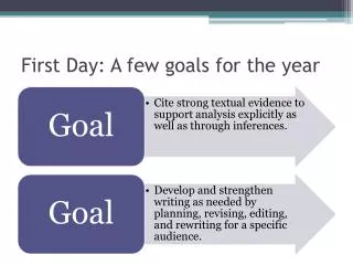
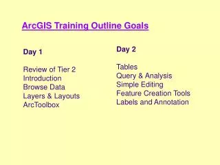
Layers and Layouts: ArcMap GUI View and display Symbolize (Lesson 6) • ArcToolbox Day 1 ArcGIS Goals for the Afternoon
Title bar: Shows map name Menu bar Standard toolbar Sizable! Drag divider Table of Contents: Data views and layer legends are listed in the dockable Table of Contents Display area: Map features draw in the display area Context menus:Right-click data or layers Status bar: Describes selected buttons and menu items; reports coordinates Exploring the ArcMap interface
Maps contain layers • Layers: • have (point to) a data source • can be saved with a map • can be saved as a file (Streets.lyr) • have symbology
Layer data sources • Feature layer from a feature class (points, lines, polygons) • Geodatabase, coverage, shapefile, CAD • Raster layers • Grids and images
Adding layer data • Using ArcCatalog • Drag data from ArcCatalog to ArcMap • Using ArcMap • File > Add data, Table of Contents context menu, Add Data button • You pick the data and ArcMap generates a layer to point to that data
Working with layers in the Table of Contents • Layers draw in their Table of Contents order, bottom up • Drag layers to reorder • Show, hide, rename, or remove layers • Group similar layers • View the source data
Setting layer properties • In ArcMap or ArcCatalog • General • Source • Selection • Display • Symbology • Fields • Definition query • Labels
Changing layer symbol and color • Right-click a symbol to set its color • Left-click to change symbol properties
Exploring your data • Magnify and Overview windows • Spatial bookmarks • Zoom and Pan • Identify • Find • Hyperlinks • Layer tables
Same data, different views • Magnify window • Live or snapshot • Drag update • Scale (%) • Overview window • Red zoom box
Keeping track of where you have been • Spatial bookmarks • Creating bookmarks • Naming bookmarks • Returning to a bookmarks
Identifying a feature • Identify features in multiple layers • Set bookmarks • Add hyperlinks • Can add multiple hyperlinks for a single feature
Finding a feature • Search • All layers • Selectable layers • One layer by name • Flash • Zoom • Identify • Set bookmarks • Select the feature
Looking at layer tables • Display tabular information • Formatted into records (rows) and fields (columns) • Contain descriptive information about features • Every layer has a table • One record per feature
Setting layer properties • General • Source • Selection • Display • Symbology • Visibility • Fields • Definition query • Labels (Lesson 17) • Joins and relates (Lesson 9)
Setting visibility scale • Minimum display scale • Maximum display scale Visible scale
Changing the data source for a layer • Map documents can lose track of the source data • Source data gets moved • Source tab lets you change the data source for a layer • Shortcut: Right-click the layer data > Data > Set Data Source Layers with misplaced data Click here to change the data source
Selection color • Default • Selection symbol • Selection color
Display properties • Map tips • Need spatial index for coverage and shapefile line and point feature classes • Scale symbols when reference scale is set • Transparency • Hyperlinks • Document • URL • Macro • Excluded features • Features can be excluded from drawing when converted to graphics
Drawing properties • Single symbol • Unique value • Graduated colors andsymbols • Proportional symbol • Dot density • Charts • Imports symbology from layers or ArcView AVL files
Using the classification histogram • Manage class breaks • Define • Interval • Number of classes • Method • Right-click the histogram to • Zoom in or out • Insert/Delete breaks • Center the histogram
Examining the Fields property • Inspect field definition information • Set a primary display field (for map tips) • Make an alias • Change the number format • Currency • Numeric • Move
Creating a definition query • Create a query string • Only displays queried features • Does not affect source
Data frame properties • Units • Frame and background symbology • Coordinate system • Illumination • Light source for 3D data • Grids • Labels and annotation • Show extents for other data frames
Ways to create a map • Create a map from scratch • Modify an existing map • Use predefined map templates
Choosing a page size • Defined by printer • Printer margins included • Custom paper size • Printer margins not included
Inserting map elements • Insert menu • Data frame • Text • Neatline • Legend • North arrow • Scale bar • Scale text • Picture • OLE object (MS Word, Excel, etc.) • Drawing toolbar • Graphics • Text
Design aids • Snapping elements • Rulers • Guides • Grids • Margins
Arranging map elements • Group and ungroup • Graphics operations • Front and back draw order • Nudge • Align • Distribute • Rotate and flip • Properties
Viewing a map • Layout view • Work with the map page (e.g., place map elements) • Data view • Work with the data(e.g., edit features) Layout view Data view
Layout view Data frames • Containers for layers and graphics • Can have indexes and graticules • Have a coordinate system • Project on the fly • First layer sets default USA data frame (Albers Equal Area) World data frame (No projection)
Focused Selected Active Data frame status • Select to move • New layers are added to active data frame • Data view displays active data frame (bold in TOC) • Focus to add graphics inside the data frame
Storing map documents • Saved as MXD file by default • Can save as a template (MXT) • Can store relative or full path names • File > Map properties > Data Source Options • Graphic formats • BMP, EMF, EPS, PDF • ArcPress formats • BIL, BIP, BSQ , TIFF, JPEG, PCX, PNG
Log-in to ArcGIS • Let’s start ArcGIS. just type “dts” in your Explorer browser ( https://dts.gov.bc.ca/ ) • Let’s try some exercises to learn how to navigate around.
ArcToolbox Goals • Introduction to ArcToolbox • Tool groups • Tools • Toolbox options • How ArcToolbox works
Introduction to ArcToolbox • Graphical User Interface for Geoprocessing framework • Hundreds of tools. • Works with ArcCatalog and ArcMap (drag and drop)
The Tool tree • Tools organized by function • Tree is only three levels deep: easy to find the tool you want • Tree objects Toolbox Tool sets Models Scripts Tools
Toolboxes • Data Management • Merge, Append, Copy, Rename • Analysis • Clip, Buffer, Erase, Intersect, Union • Conversion • Convert GIS data between coverages, shapefiles, geodatabase, CAD
Working with tools • One panel • Help The Buffer tool
Setting input/output dataset names • Entering your data • Type into field • Drag to field from ArcCatalog • Use minibrowser
Finding tools • Find tools from Index or Search tab.
Model Builder • Workflow diagram • Series of processes executed in a sequence.
Congratulations, we’re done Part 2! • Questions!? • Up next, tomorrow morning, Part 3: • Tables • Query & Analysis • Graphs & Reports