Download
1 / 1
10 likes | 136 Views
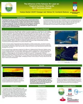
The Influence of the Saharan Air Layer on Tropical Cyclones During the 2011 Hurricane Season. Katelyn Barber (SUNY Oswego) and Advisor Dr. Humberto Barbosa. Introduction. Objective.

E N D
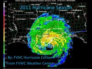
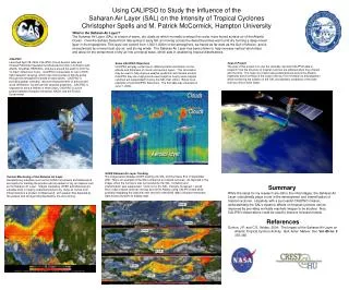
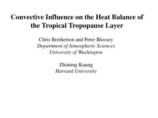
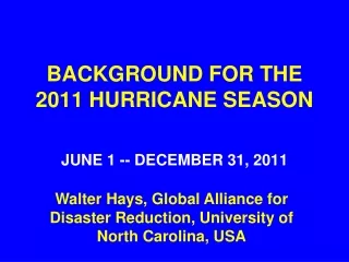
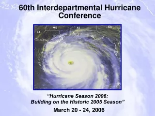
The Influence of the Saharan Air Layer on Tropical Cyclones During the 2011 Hurricane Season Katelyn Barber (SUNY Oswego) and Advisor Dr. Humberto Barbosa Introduction Objective The Saharan Air Layer is an elevated dry, warm air mass containing West African dust particles that migrates across the North Atlantic Basin during early spring to late fall. The SAL is characterized by humidity values less than 50% of tropical air and winds stronger than 15 knots. The Saharan Air Layer impacts the development of tropical cyclogenesis in productive and destructive ways making it unclear whether or not the Saharan Air Layer is responsible for a general increase in tropical cyclones over the last decade. In this study we will provide a preliminary investigation of the 2011 Hurricane Season and the influence the Saharan Air Layer had on three tropical storms that developed near the Saharan Air Layer. Using Meteosat satellite infrared images we were able to track the Saharan Air Layer from June to October, by taking the difference between 12.0 micrometers and 10.8 micrometers infrared images using McIDAS-V. Theory and Methods Exactly how the Saharan Air Layer affects the conditions for tropical cyclogenesis is still debated by meteorologists. According to Karyampudi and Carlson (1988), the SAL contributes to easterly wave growth, which in turn contributes to tropical cyclogenesis. There are documented storms intensifying within the vicinity of the SAL, one of these is Hurricane Helena. On 16 September2006, Helena was surrounded by air with relative humidity values around 20% to the north, yet later that day it intensified and by 18 September 2006 Helena was a category 3 hurricane (Braun and Shie 2008). On the other hand, scientists have also concluded that the SAL inhibits tropical cyclogenesis for three main reasons. First, the temperature inversion created by the radiative warming of dust over the ocean water stunts convective development. Secondly, the vertical wind shear within the SAL removes heat and moisture, decreasing instability. Lastly, the dry SAL air intruding into tropical cyclones create cold downdrafts, and lower convective potential energy available for the cyclone (Emanuel 1989). The 2011 hurricane season observed twenty tropical depressions, nineteen tropical storms, and seven hurricanes (four being major hurricanes). Statistically, 2011 was an above average year for tropical storms but an average year for hurricanes. The Saharan Air Layer may have been a reason as to why so many tropical storms formed, but never developed into hurricanes. Dry Air Tracking Product images were created from the difference of Meteosat Second Generation Satellite infrared 12.0 micrometers images and 10.8 micrometers images from 1 August to 6 August 2011 of Tropical Storm Emily, 29 August to 6 September 2011 of Hurricane Katia, and 6 September to 10 September 2011 of Hurricane Maria with McIDAS-V. In these images the color red is dry air, and green air is moist air. The Cooperative Institute for Meteorological Satellite Studies archived SAL/Dry Air Product, the Mid-Low Level Wind Product, and Mid Level Water Vapor Enhanced for Dry Air Tracking Product at 7.3 micrometers for the North Atlantic Basin were used as qualitative data and a comparison to the created images. Investigating the data, we were looking for obvious influences the SAL had on tropical cyclone development. . Figure 1. Schematic of the Saharan Air Layer, Courtesy of METED Results The Saharan Air Layer delayed Emily’s organization and later in her life span eroded the northwest portion of the cloud formation and exposed the core to stable air. It was not until Emily was completely removed from the dry environment did she gain strength and return to tropical storm status. The overall effect the Saharan Air Layer had on Katia was minimal. Due to the weak phase of the SAL, Katia had optimal conditions to form; warm waters, little wind shear, and instability. The concentrated Saharan Air Layer in the south may have played a key role in the strength of the tropical wave that Katia developed from. Similarly to Hurricane Katia, Hurricane Maria formed to the north of an area of concentrated dry air and the Saharan Air Layer was still in a weakened state. However, during the development of Maria there was a significant amount of vertical shear that inhibited the growth of the storm.But once removed from the dry air strengthened. Conclusion References Acknowledgments . The presence of dry air near the West African coast increases the frequency of easterly waves because of the vertical wind shear and vorticity. Easterly waves increase the occurrence of tropical disturbances. However, the Saharan Air Layer inhibits tropical cyclogenesis once a low has developed. From a preliminary investigation this is a possibility because all major hurricanes during the 2011 season developed once away from the Saharan Air Layer. Braun, S. A., and, C. L. Shie, 2008: Examination of the influence of the Saharan Air Layer on hurricanes using data from TRMM, MODIS, and AIRS.AMS Conf. On Hurricanes and Tropical Meteorology, Orlando, Fl, 13B6. Brennan, M. J., 2012: Tropical Cyclone Report Hurricane Maria. National Hurricane Center. AL142011, 25 Chen, Y.-L., 1985: Tropical squall lines over the eastern Atlantic during GATE. Mon. Wea. Rev., 113, 2015– 2022. CIMSS, Cooperative Institute for Meteorological Satellite Studies, Space Science and Engineering Center: Dry Air/SAL tracking product, Low-Mid level wind overlay, Mid-Low Level water vapor enhanced for dry air tracking, June 2011-Spetember 2011, http://tropic.ssec.wisc.edu/archive/ Dunion, J. P., and C. S. Velden, 2004: The impact of the Saharan air layer on Atlantic tropical cyclone activity, Bull. Am. Meteorol. Soc., 85(3), 353–365. Emanuel, K. A., 1989: The finite-amplitude nature of tropical cyclogenesis. J. Atmos. Sci., 46, 3431–3456. Karyampudi, V.M., and T.N. Carlson, 1988:Analysis and numerical simulations of theSaharan air layer and its effect on easterlywave disturbances. J. Atmos. Sci., 45,3102-3136. Kaufman, Y. J., D. Tanré , O. Boucher, 2002: A satellite view of aerosols in the climate system. Nat.,419, 215-223. Kimberlain, T. B., and J. P. Cangialosi, 2012: Tropical Cyclone Report Tropical Storm Emily. National Hurricane Center. AL052011, 17 Krueger, B. J, V.H. Grassian, J.P. Cowin, and A. Laskin, 2004: Heterogenous chemisty of individual mineral dust particles from different dust source regions: the importance of particle mineralogy. J. Atmos. Sci., 38, 6253-6261 Michalak. A. E., 2004: Properties and influences if the Saharan air layer on tropical cyclogenesis. Department of Physics, University of Colorado, pp. 16 Randall, D. A., Harshvardhan, D. A. Dazlich, and T. Corsetti, 1989:Interactions among radiation, convection, and large-scale dynamics in a general circulation model, J.Atmos. Sci., 46, 1944-1970. Stewart, S. R., 2012: Tropical Cyclone Report Hurricane Katia. National Hurricane Center. AL122011, 20 Sun, D., K. M. Lau, and M. Kafatos, 2008: Contrasting the 2007 and 2005 hurricane seasons: Evidence of possible impacts of the Saharan dry air and dut on tropical cyclone activity in the Atlantic basin. Geo. Res. Let, 35, L15405