Create Range Cards for Land Operations
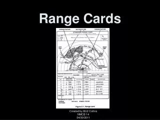
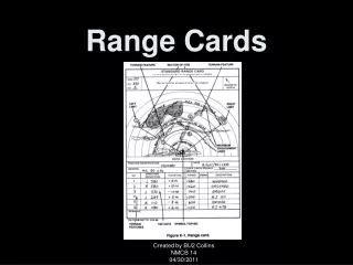
Create Range Cards for Land Operations. Joe Bayles. Agenda. Introduction Create Range Cards Demo Questions. Introduction. Based on Department of the Army Form 5517-R, Standard Range Card Sector sketch for a direct fire weapon system Used to plan and control fires and target acquisition


Create Range Cards for Land Operations
E N D
Presentation Transcript
Create Range Cards forLand Operations Joe Bayles
Agenda • Introduction • Create Range Cards Demo • Questions Create Range Cards for Land Operations
Introduction • Based on Department of the Army Form 5517-R, Standard Range Card • Sector sketch for a direct fire weapon system • Used to plan and control fires and target acquisition • Plots target areas and terrain features • Combined to create the unit’s sector sketch • Other versions of Range Cards vary by organization Create Range Cards for Land Operations
Important Concepts • Sectors of fire – piece of the battlefield for which that gunner is responsible • Target Reference Points – natural/man-made features designated for target acquisition and range determination • Dead Space – any area that cannot be observed within a sector of fire • Maximum Engagement Line – depth of the area and limited to maximum effective range of the weapon system • Weapons Reference Point – easily recognizable terrain feature for plotting a weapon position Create Range Cards for Land Operations
Create Range Cards Joe Bayles Create Range Cards for Land Operations
Known Issues We’re always looking to improve… Model Builder Issue: !gridcode! vs. !grid_code! Sketching dead space vs. running a visibility tool No Maximum Engagement Line Support for multiple weapon systems Lack of guidance and outdated references DA 5517-R references FM 3-21.71, which is now ATTP 3-21.71 ATTP 3-21.71 references FM 3-21.75, which is now outdated Create Range Cards for Land Operations
Resources Solutions Page (download the template) http://solutions.arcgis.com/military/land-operations/planning/ Resources Page (the closest thing to the user manual) http://resources.arcgis.com/ Ideas Page (usually for improvement) http://ideas.arcgis.com/ Create Range Cards for Land Operations
Thank you… Please fill out the session survey- Offering ID: 1892 Questions- Now’s the time to ask, or you could… Please come ask me directly Email me at jbayles@esri.com Contact your Account Manager Create Range Cards for Land Operations