Download
1 / 7
70 likes | 168 Views
Discover the essentials of geography, from measurements of the Earth to the five fundamental themes - Location, Place, Relationships, Movement, and Regions. Learn about latitude and longitude, hemispheres, human-environment interaction, and regional divisions. Explore how geography shapes our understanding of the world.

E N D
Measurements of the Earth • Most maps contain imaginary horizontal and vertical lines of measurement. Horizontal lines running east and west are called _Latitude_____ lines? Vertical lines running north and south are called ____Longitude____ lines? • The Four Hemispheres: • Cut the earth in fours Northeastern and Northwestern, Southeastern, Southwestern,
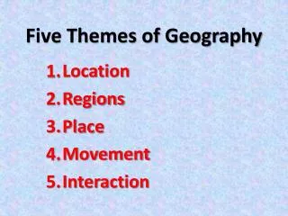
First is Location • The first question is always “where”? • You need the ability to describe where things are located. • Two ways to describe location is Relative location or absolute location. • Relative Location: where a place is in relation to other places.(biggest city closes to you) • Absolute Location: direct us to a precise position on earth. (your home address)
Second is Place • Every place has many distinctive characteristics. • Natural Characteristics—landforms, climate, and animal life • Cultural Characteristics—shopping centers, languages, and political systems • Ways of Representing of places are with a scale module, and map symbolism.
Third is Relationships within Places (human-environment interaction): • Humans interact with the environment in many ways. • People depend on the environment for their basic needs • People adapt to the environment with clothing, housing and use of land • People change the environment with techniques in farming and use of resources.
Fourth is Movement • People, Products, Information, and ideas move in patterns that are mappable. • Movement concerns human interaction. • Linkages—countries of origin, all types of transportation and communications. • Interdependences—foods, raw materials, and manufacturing. • Patterns: movement can be seen in exploration, trade, settlement, and invasion.
Fifth is Regions • Geographers divide the World into manageable units of study called regions. • A region can be defined by Natural, Cultural, or Boundary change over time. • Natural Region—landforms, bodies of water, and climate conditions • Cultural Region—political units, race, religion, or several such factors • How Regions Change—change in boundaries, population, and alliances.