O, CANADA!
470 likes | 498 Views
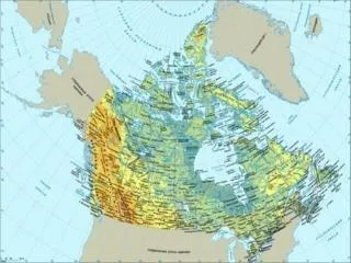
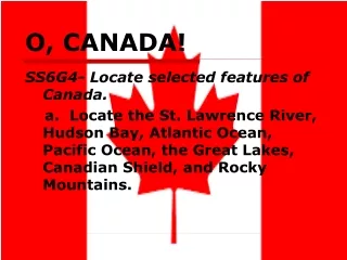
O, CANADA!. SS6G4- Locate selected features of Canada. a. Locate the St. Lawrence River, Hudson Bay, Atlantic Ocean, Pacific Ocean, the Great Lakes, Canadian Shield, and Rocky Mountains. Satellite Image of Canada. 3. 1. 5. 2. 7. 4. 6. The Canadian Shield.

O, CANADA!
E N D
Presentation Transcript
O, CANADA! SS6G4- Locate selected features of Canada. a. Locate the St. Lawrence River, Hudson Bay, Atlantic Ocean, Pacific Ocean, the Great Lakes, Canadian Shield, and Rocky Mountains.
Satellite Image of Canada 3 1 5 2 7 4 6
The Canadian Shield • The Canadian Shield is covered by a thin layer of soil and contains many rock outcroppings. • It stretches from the Great Lakes to the Arctic Ocean, covering over half of Canada. • Population is scarce.
The Rocky Mountains • Form the border of British Columbia and Alberta. • Formed by glaciers • Run all the way to New Mexico (over 3,000 miles).
Hudson Bay • Approximately 850 miles long and 650 miles wide. • In early November ice begins to form on the bay.
The Great Lakes (HOMES) • Huron, Ontario, Michigan, Erie, Superior • They form the largest chain of freshwater lakes on earth. • Sometimes referred to as inland seas.
Great Lakes Lock System http://huron.lre.usace.army.mil/SOO/alock.html
The Great Lakes • The Great Lakes contain 22% of the world’s freshwater. • This is enough water to cover the lower 48 states with 9.5 ft of water!! • Lake Superior is the deepest of the 5 at 1,333 ft deep. Superior quite often has waves larger than most oceans. • Lake Superior is the largest freshwater lake in the world in terms of surface area and the third largest in volume.
Lake Superior Videos • http://www.youtube.com/watch?v=F3zqUad8A5A • http://www.youtube.com/watch?v=BpFnqWX3pLE • Shipwrecks- The November Witch https://www.youtube.com/watch?v=nhZ65X0TAsw
St. Lawrence River • Connects the Great Lakes to the Atlantic Ocean • Major shipping route • Allows a boat to travel from Duluth, MN all the way to Europe and beyond! • Final completion of the seaway was in 1959.
Political Map of Canada 10 Provinces 3 Territories
STANDARD SS6G5: a. Describe how Canada’s location, climate, and natural resources impact trade and affect where people live.
How Does Canada’s Location Affect Where People Live? • Canada is the largest country in the Western Hemisphere in land area. • 2nd largest in the world in terms of land area. • Bordered by three oceans: • Atlantic • Pacific • Arctic Bordered by the USA to the south and Alaska to the Northwest From a polar point of view, Canada also is in an important position between the United States and Russia
Where do people live? • 90% of Canadians live within 100 miles of the US border • Highest population centers are in the eastern and central parts of the country. • Population of Canada is about 33 million people. • Canada’s population is small compared to its size. • The USA has 9x the number of people of Canada.
Climate of Canada Even though Canada is so large, the climate keeps most of its people living in a few southern areas. Would you want to live here??
Most Canadians live in the southern part of their country because the north has very cold winters and cool summers Northern Canada has subarctic and arctic regions = long cold winters & short cool summers (can be below freezing in summer). Climate of Canada
Natural Resources (Gifts of Nature) Canadians have a country rich in natural resources: • Iron Ore • Nickel • Zinc • Copper • Gold • Lead • Potash • Diamonds • Silver • Lumber • Fresh Water
Natural Resources • Because many of Canada’s natural resources are in remote areas, Canadians are spread across their country. • Small communities are found near mining and farming. • People live near rivers and the sea for jobs.
Trading of Natural Resources How is Canada’s location beneficial to trading its resources?
Trade • Canada’s location in the world helps it to be a leader in world trade. • HOW?? It is bordered by three oceans: Arctic, Atlantic, Pacific. • This allows Canada opportunities to trade with both Europe and Asia. • Canada has 9 major ports and numerous smaller ones.
Trade • The St. Lawrence River and Great Lakes also allow goods to be shipped to and from central Canada to the Atlantic Ocean. • U.S. and Canada share 3,000 miles of border. Trading along this border is easy. • 80% of Canada’s exports go to the U.S.!
Trade • Farmers produce canola, wheat and other grains to export to other countries. Timber is also exported. • Excellent system of highways and railroads have been built and adapted to the colder climate. • Canada produces hydroelectric power along its rivers. Power not used in Canada is sold to the U.S.
a. Explain the causes and effects of pollution and acid rain in Canada to include the Great Lakes. b. Explain the causes and effects of the extraction of natural resources from the Canadian Shield (e.g., mining and logging). Standard SS6G6:Explain the impact of environmental issues in Canada.
1) Acid Rain in Canada Cause: factories and automobile emissions (50-70% comes from the U.S.!) Effects: • damage or killing of plants/trees • pollution of lakes and rivers (enough to kill the fish) • destruction of monuments and buildings.
Remember learning about chemical weathering in science class? What is acid rain? • Sulfur dioxide, carbon dioxide, and nitrogen oxides are put into the air; they mix with water molecules and turn the water acidic. • Cloud or rain drops that are acidic are called acid rain.
Solution for acid rain: How do you think Canada could reduce its amount of acid rain? **Hint: Think about the causes of acid rain.
2) Pollution of the Great Lakes Cause: • Phosphorus levels from factories are too high. • Phosphorus is used in the U.S. and Canada. • Large quantities of Phosphorus cause an algal bloom (too much algae) which eventually kills plants and animals.
Pollution of the Great Lakes Effects: • Loss of drinking water (odor/bad taste) • Fish tumors and deformities • Loss of wildlife and their habitats
Pollution of the Great Lakes Solutions: • Both countries agreed to reduce their use of the chemical. • Great Lakes Water Quality Agreement was signed between the U.S. and Canada to reduce amount of chemicals and human waste dumped into the lakes.
3) Extraction of Natural Resources in Canadian Shield Remember: The Shield has a thin and rocky layer of soil. Extraction-the act of taking out something using effort or force Cause:Beneath the soil is one of Canada’s most valuable resources—minerals such as nickel, gold, silver, and copper.
Extraction of Natural Resources in Canadian Shield Mining for resources is messy work! Think: why?? Effects: loss of trees water contamination loss of wildlife habitats soil depravation
Solution: New rules about mining will reduce the amount of pollution allowed in Canada’s waterways. The government hopes this keeps fish alive and safe to eat. Extraction of Resources in the Canadian Shield
Cause:Loggers cut trees and send them to mills to make lumber, plywood, and wood pulp. Effect:Seriously disrupts forest habitats. Can also lead to flooding and eutrophication. 4) Clear-cutting of Trees:The Timber Industry in Canada
Clear-cutting of Trees Clear-cutting is when all the trees in an area are cut and a large treeless gap is left in the forest. Clear- cutting in British Columbia
Clear-cutting of Trees Solutions: The companies and government are working together to manage use of the forests. Logging companies spend over $100 million each year to protect wildlife and their habitats.