Download
1 / 42
420 likes | 592 Views
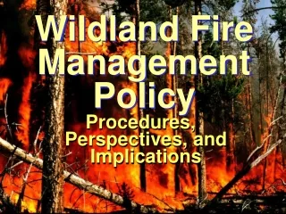
Lion Wildland Fire Background The Lion Fire was ignited by lightning on July 8, 2011 in the Golden Trout Wilderness on the Western Divide Ranger District, Sequoia National Forest. . Impacts

E N D
Lion Wildland Fire Background The Lion Fire was ignited by lightning on July 8, 2011 in the Golden Trout Wilderness on the Western Divide Ranger District, Sequoia National Forest.
Impacts • The Golden Trout Wilderness evolved with fire. Under current fuel and weather conditions, we can manage the Lion Fire to restore resilience to the ecosystem, improve wildlife habitat, and reduce heavy accumulations of flammable fuels, while we actively protect lives, property, and resources.
Air quality and smoke: • We care about the impacts that smoke has on human health of our visitors, our employees, and residents • We are working with San Joaquin Valley Air Pollution Control District as well as the Eastern Kern and Great Basin districts to plan ignitions during favorable weather patterns and smoke dispersal, monitor particulate matter from smoke, and share that information with the public, residents, and employees.
Prior to American suppression policies, fires ignited by lightning in the summer months would burn throughout the late summer and fall in the Sierra Nevada. These fires would slowly smolder with the cooler and shorter days and eventually be extinguished by rain or snow, and occurred every 15-20 years in the Sierra Nevada.
Land Management Responsibilities • We are mandated by our Land Resource Management Plan and the Wilderness Act to use fire for ecological restoration. Goals for fire and fuels management include reducing threats to communities and wildlife habitat from large, severe wildfires and re-introducing fire into fire-adapted ecosystems.
These goals were vetted through public review and are part of our “contract” with the American people. We have a legal obligation to follow this contract and the best available science to back these decisions.
We know that the communities surrounding the forest are affected by fire management decisions. We attempt to find a balance in the program that addresses the public’s concerns while also returning natural fire to the landscape to reduce the risk of larger, unwanted fires and to achieve the ecological benefits of fire.
View of the spot fire after it crossed the Little Kern heading west into Soda creek
View of the Lion Wildfire burning on the Sequoia Kings Canyon National Parks
Lion Wildfire MODIS satellite 13:51 PM on July 28, 2011 Lion Wildfire Bald Mountain Camera 1 13:51 PM on July 28, 2011
Jordan Peak looking East to Olancha Peak
Jordan Peak looking East to Olancha Peak on August 03, 2011 @09:29 AM
Jordan Peak looking Southeast to Needles Lookout on August 03, 2011 @09:30 AM
Tobias Peak looking Southeast towards Kernville and Lake Isabella
Tobias Peak looking Southeast towards Kernville and Lake Isabella on August 03, 2011 @ 09:31 AM
Tobias Peak looking South towards Sunday Peak on August 03, 2011 @09:33 AM
Breckenridge Lookout looking North to Lake Isabella on August 03, 2011 @09:36
2003 Kern Valley Smoke Impacts Kernville – 9/21/03, 0800, Baker Point (7,753 ft. elevation) 8 miles north of Kernville (2,760 ft. elevation). Two miles.
2003 Kern Valley Smoke Impacts Kernville – 9/21/03, 1400, Baker Point 8 miles north of Kernville. Two miles.