Evolution of GRDC Stations and Current Projects in Hydrological Data Management
Explore the spatial distribution and development over time of GRDC stations using monthly discharge data. Learn about ongoing projects including GTN-R and ETN-R, as well as GIS products updates and participation in international programs. Find more information on WMO Sub-Regions, WHYMAP, and EWA within GRDC Major River Basins. Routine tasks cover data acquisition, database management, metadata, GIS layers, publications, and website maintenance for data dissemination. Contact Ulrich Looser at looser@bafg.de for further details.

Evolution of GRDC Stations and Current Projects in Hydrological Data Management
E N D
Presentation Transcript
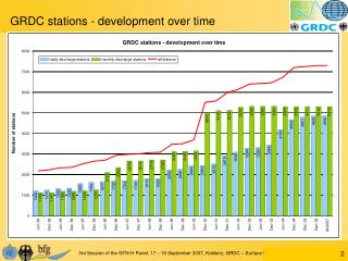
Spatial distribution of GRDC Stations indicated by time series end, (monthly discharge data including data derived from daily discharge data)
Spatial distribution of GRDC Stations indicated by time series length, monthly discharge data including data derived from daily discharge data)
Current GRDC Projects GTN-R project ETN-R project Update of some GIS products • WMO Sub Regions • Drainage basin and River network as basis for WHYMAP (World-wide Hydrogeological Mapping and Assessment Programme) • GRDC Major River Basins EWA (European Water Archive) of NE-FRIEND • Define data model for EWA • Transfer data • Adjust database tools Routine work on data acquisition, database management, metadata issues, GIS layers, publications, website maintenance and data dissemination Participation in international projects and programmes e.g. GCOS, GTOS, TOPC, GEWEX CEOP, GEO etc.
Please visit:GRDC at http://grdc.bafg.de Thank you for your interest: Ulrich Looser looser@bafg.de