Download
1 / 31

E N D
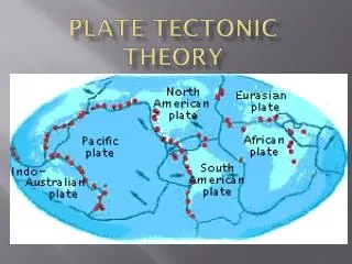
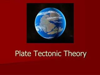
Plate Tectonic Theory One Theories Journey
Continental drift -- One theory's journeyToday, you might be laughed out of a geology course for questioning whether continents move through geologic time. But 75 years ago, only skeptics believed that continents could take a hike. Talk about conventional unwisdom: W.B. Scott, former president of the American Philosophical Society, even called the theory of continental drift "utter damned rot." (!) What's changed? Not the actual movement of continents, but our understanding of geology itself. Let's take a look at how the theory developed, and how the evidence began to favor it.
Antonio Snider-Pellegrini suggests that continents were linked during the Pennsylvanian period (325 million to 286 million years ago), because Pennsylvanian plant fossils from Europe and North America were similar. (See "carboniferous" on this time line.
Australian geologist Edward Seuss sees similarities between plant fossils from South America, India, Australia, Africa and Antarctica, and coins "Gondwanaland" for a proposed ancient super-continent with these land masses.
F.B.Taylor 1910 • American physicist F.B. Taylor proposes concept of continental drift to explain formation of mountain belts. • Unfortunately no one remembers him or has his photo because he did not support his theory with emperical evidence!
Alfred Wegner 1912 • German meteorologist Alfred Wegener proposes theory of continental drift, based on evidence from geology, climatology and paleontology. Wegener names one of the ancient super-continents "Pangea," and draws maps showing how the continents moved to today's positions.
How’d they move again? • Assorted arguments are used to debunk continental drift, most importantly the lack of a mechanism strong enough to move continents across or through ocean basins.
South African geologist Alexander du Toit maps out a northern super-continent, "Laurasia," to explain coal deposits, which presumably indicate the remains of equatorial plants, in the Northern Hemisphere.
Paleomagnetism • Paleomagnetism: British scientists find that magnetic fields recorded in rocks from Europe and North America indicate the rocks were formed in far different locations than their present positions. The pattern of continental drift recorded by rocks show Europe and North America have drifted away from each other for more than 100 million years. This movement opened the Atlantic Ocean.
Gondwana • Fossils of the plant genus Glossopteris occur on all five Gondwana continents. The seeds were too heavy to be carried by wind, and would have died quickly in salt water, indicating that the continents were once joined. Similarly, fossils of several reptiles occur on several continents.
Appalachian Mountain Chain • The Appalachian Mountain chain can be linked with mountains in Greenland, the United Kingdom and Norway, indicating that these land masses were joined at the time the mountain chain formed
Marks left by glaciers on rocks in Africa, India, South America and Australia make no sense -- unless these continents were joined and arrayed around the South Pole. Then, the glacial scars would have all pointed away from the Pole when they were made. Today, glaciers form near the poles and move away as they travel and eventually melt.
Ocean Floor • The oldest rocks on the ocean floor are younger than 220 million years, while the oldest terrestrial rocks are about 4 billion years old, indicating that the ocean floor is recycled back into the Earth.
Earth's magnetic field periodically changes polarity (your compass would point to the South Pole). When magma solidifies at the mid-oceanic ridges, it records the polarity of the Earth's magnetic field. Bands of seafloor basaltic rocks paralleling the mid-oceanic ridges carry a record of this alternating polarity.
Geologists think convection cells in the mantle (the hot, plastic rock under the crust) power continental movements, overcoming an early objection to continental drift.
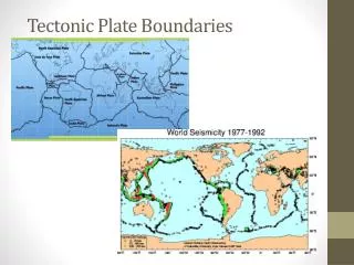
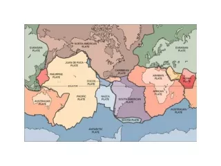
Plate Boundries • Three kinds of boundariesContinental drift -- or plate tectonics -- involves a lot of complicated motion at the plate boundaries. The tamest version generally occurs beneath the oceans, when plates move away from each other. At these divergent plate boundaries, molten magma rises and solidifies into solid rock, filling the gap formed as the two plates move apart. These spreading centers (see figure below or the graphic at the top of this page) form ridges on the seafloor. As spreading continues and the rocks move away from the ridge, they cool and contract as they age. The movement usually occurs at a relatively constant rate of a few centimeters per year and tends not to produce large earthquakes.
Either of the other two types of boundaries may be associated with large earthquakes. At transform plate boundaries one plate moves laterally against and past another. Some transform boundaries are also described as strike slip faults. At a convergent boundary, one plate must either slip beneath the other (a subduction zone) or the two plates must collide (a collision zone). A classic subduction zone has a denser oceanic plate diving, or "subducting", beneath a less dense continental plate.
But when a giant rock hits an immovable object -- when one tectonic plate moves suddenly against another -- the havoc of a major earthquake can result. Lacking the stress relief of regular, minor earthquakes, strong rock gets stuck at the fault zone, allowing strain to build up.
When the strain gets too great, it is relieved by the sudden movement causing a major earthquake. The greater the strain, the larger the earthquake. Thus in a sense, earthquakes should be predictable if we know the strain and the strength of the rocks.
Unfortunately, despite that simple equation, precise predictions of quakes are not possible now. Beyond problems measuring the strength of rocks, we have only a foggy picture of the triggering mechanism. "How the slip on a fault starts is a fundamental problem in seismology," says Clifford Thurber, a geophysicist at the University of Wisconsin-Madison. "We don't really know the conditions and state that a fault is in when it starts moving."
The problem, simply, is inaccessibility. Earthquakes start underground -- sometimes dozens or hundreds of kilometers deep, and "there is no direct way to detect conditions," as Thurber says. Indirect measurements may offer a guideline, but direct observations would be preferable.
That's one reason for a recent proposal to drill 3.5 kilometers into the San Andreas Fault to obtain direct measurements from that active region. Thurber notes that cores removed from the hole would be examined for strength and fluid content. Instruments in the hole itself would look at fluid pressure, which may be implicated in initiating quakes. "We want to get direct measurements of the physical properties for the first time," Thurber says
The project would be a step toward the eventual -- and we stress eventual prediction of earthquakes. We'll get to that prospect shortly.
References • Earth Quakes @ Geology wise. Edu • http://www.geology.wisc.edu/courses/g115/quake/5.html • The information in this presentation was taken almost in its entirety from Geology Wisconson.edu