Download
1 / 12
120 likes | 229 Views
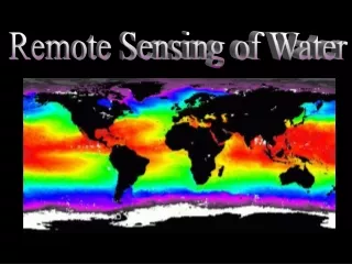
Contribution of Remote Sensing Technology to Catchment Water Resources Management. Toshio Koike 1 and Dara Entekhabi 2. 1 University of Tokyo 2 Massachusetts Institute of Technology. 5 th IHP/IAHS George Kovacs Colloquium June 2-3, 2000. Outline: Definitions: What is needed?

E N D
Contribution of Remote Sensing Technology to Catchment Water Resources Management Toshio Koike1 and Dara Entekhabi2 1 University of Tokyo 2 Massachusetts Institute of Technology 5th IHP/IAHS George Kovacs Colloquium June 2-3, 2000
Outline: • Definitions: • What is needed? • What is measured? • What is available? • Case examples. • What are the challenges? • Science. • Application. • What is the next step?
“In the history of the hydrologic sciences as in other sciences, most of the significant advances have resulted from new measurements.” p.214, Opportunities in the Hydrologic Sciences, NAS, 1991. New data types force the rethinking of conceptual frameworks and analysis approaches in science as well as in applications.
What hydrometric data is needed for catchment management? • Site characterization: • Topography and drainage • Land use • Geology • Hydrologic inputs: • Rainrate • Snowpack • Losses: • Evapotranspiration • River discharge • Status: • Flood inundation • Soil moisture • Crop conditions • Water turbidity
Remote Sensing vs. in situ • Emerging technological advances in sensors and remote platforms • allow measurements with coverage, and cost- and • quality-effectiveness exceeding in situ networks. • The steps to using remote sensing measurements: • Geophysical inversion: Relate spectral radiation to relevant variable • Resolution: Interpretation of measurement that is area-effective
Characterization: • Digital elevation and land use classification at 25m resolution globally • Hydrologic Inputs: • Rainrate and snowpack at 2 to 25 km upto 6-hourly • Losses: • Evaporation and discharge are TBD • Status: • Flood inundation now possible at 10m • Soil moisture TBD but tens of kilometers
Up to 30 m resolution classification and monitoring of vegetation and crops
What are the challenges? • Hydrologic Science and Remote Sensing Technology • Interpretation of areal measurements in the presence of spatial variations • Added-value data products from merging hydrologic models and measurements • Applications to Catchment Water Management • Mapped attributes and spatial information systems as the analysis framework • Re-examine monitoring Þ assessment Þ control in the context of this new data type
Next step? • In the context of a demonstration basin: • Measure the cost-effectiveness of relying on remotely sensed data • Measure the influence of (internal) spatial interactions in resource use