Download
1 / 25
260 likes | 453 Views
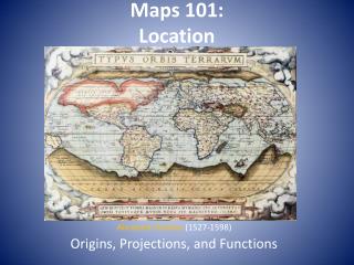
Maps 101: Location. Abraham Ortelius (1527-1598) Origins, Projections, and Functions. Early Mapmaking:. Earliest surviving maps: ~1700 BC Middle East Thales (c600bc) used geometry to measure land areas … Anazimander made one of the first world maps using info from traders and sailors

E N D
Maps 101: Location Abraham Ortelius(1527-1598) Origins, Projections, and Functions
Early Mapmaking: • Earliest surviving maps: ~1700 BC Middle East • Thales (c600bc) used geometry to measure land areas … • Anazimander made one of the first world maps using info from traders and sailors • Hecateus produced the first geography book 500bc • Aristotle (350bc) describe earth as a sphere • Eratosthenese (230bc) calculated the earth’s circumference (.5% accuracy!) mapped the known world (with climate regions!) • Ptolemy (100-170ad) wrote an 8-volume “Guide to Geography” defined principles and prepared maps… used for 1000 years… geographic progress in Europe stopped. It carried on in other parts of the world though…
Mapmaking outside of Europe: • PheiHsiu: the “father of Chinese cartography” produced an elaborate map of the country 267ad • Al-Idrisi: prepared a world map and text to improve on Ptolemy’s neglected work (1154) • Ibn-Battutah (1304-1368) wrote Rihlah (“travels”) covering 3 decades of journeys through the Muslim world, N Africa, S Europe, and much of Asia • … then came the Age of Discovery… guys like Columbus and Magellan revived the study of geography …to go TAKE OVER THE WORLD!
Maps Serve 2 Main Purposes: • 1. A Reference Tool: (Reference Maps) What examples of reference maps can you think of? • 2. A Communications Tool: (Thematic Maps) How can maps communicate ideas? Give some examples.
Thematic Maps: • Choropleth Maps: are used to display both quantitative and qualitative areal variables. Observations are grouped into classes and each class is assigned an areal symbol… usually a gradation of a color or shading.
Dot Maps: • Are used to indicate intensity, diffusion, density, and distribution of a phenomena in a given area.
Isoline Map: • Connect points of equal value in a given area. These are helpful in identifying a trend or building a 2D map that depicts 3D feature (topographic maps).
Cartography: mapmaking • Some essential problems: • 1. Distortion: Attempts to solve the distortion problem has led to several “fixes” called map projections. Each has their particular uses, advantages, and disadvantages.
Distortion: • Four types of distortion can result: • The SHAPE of an area can be distorted. • The DISTANCE between two points may increase or decrease • The RELATIVE SIZE of different areas may be altered. • The DIRECTION form one place to another can be distorted
Some Popular Projections: • Equal Area Projection • Advantage: relative size, shape maintained • Disadvantage: interruptions, meridians do not converge or form right angles
Robinson Projection Advantage: displaying info across the oceans Disadvantage: small land mass compared to other maps
Mercator Projection • Advantage: little shape or direction distortion, rectangular • Disadvantage: huge distortion of relative size at the poles
Polar Projection • Advantage: very accurate at center • Disadvantage: distortion all around the outter edges
Scale • The purpose of a map requires a decision concerning scale. Are we showing the Earth, a country, a city…? A scale model of the entire Earth would leave out MUCH detail for lack of space. However, a map that shows only a portion of the Earth can hold a wealth of detail. • Scale refers to the relationship of a feature’s size on a map to its actual size on Earth.
Scale is Represented in 3 Ways: • 1. A Ratio or Fraction: ex: 1:24,000 or 1/24,000 The unit of measure can be anything (inches, centimeters, finger lengths…). The first number represents what’s on the map as compared to the second number; reality.
2. A Written Scale: ex: “1 inch equals 1 mile” Again, the first number is the map. 3. A Graphic Scale: ex:
“Large is small… and vice versa” • DON’T FORGET…. a small scale map shows LARGE areas a large scale map shows SMALL areas … like the zoom function on a camera! Large or Small Scale??
Finding Places on a Map • Finding a PLACE requires identifying its LOCATION. There are several ways to do that: • The most straightforward way is by referring to a place’s TOPONYM, or “place name.” Toponyms can tell you a lot about a place. • Site: refers to a place’s physical character; climate, soil quality, vegetation, elevation, etc • Situation: the location of a place relative to other places. This observation is VERY useful in understanding spatial connections. continued...
. 4. Mathematical Location (absolute): • The location of any place on Earth can be found using meridians (longitude) and parallels (latitude). • These lines intersect to form a grid system that give us coordinates. • Meridians are drawn N-S but MEASURE distances E-W. • Parallels are drawn E-W but MEASURE distances N-S
Other Mathematical Indicators of Location: • U.S. Land Ordinance of 1785: Divided much of the country into a system of townships and ranges to help sell the frontier to settlers. Initial surveying done by Thomas Hutchins. Key concepts of the Ordinance: • Township: 6 sq. mi. divided into 36 sections 1 mi. sq. and numbered 1-36 • Principal meridians N-S lines separating townships • Base lines E-W lines separating townships
Modern Mapping Tools • Remote Sensing: the acquisition of data about Earth’s surface from satellites, planes, etc. GPS (Global Positioning System) uses a network of satellites, most commonly used for navigation… your cellphone uses it. GIS (Geographic Information System/Science) Amazing computer software that can combine multiple themes (physical and social) to produce maps that can show correlations among phenomena. You will use a GIS!