1 / 3

Map showing relative size and locations of Sderot, Ashkelon, Ashdod & Be’er Sheva

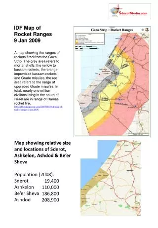
IDF Map of Rocket Ranges 9 Jan 2009.

pravat
Download Presentation

Map showing relative size and locations of Sderot, Ashkelon, Ashdod & Be’er Sheva

An Image/Link below is provided (as is) to download presentation Download Policy: Content on the Website is provided to you AS IS for your information and personal use and may not be sold / licensed / shared on other websites without getting consent from its author. Content is provided to you AS IS for your information and personal use only. Download presentation by click this link. While downloading, if for some reason you are not able to download a presentation, the publisher may have deleted the file from their server. During download, if you can't get a presentation, the file might be deleted by the publisher.

E N D

Presentation Transcript


  1. IDF Map of Rocket Ranges9 Jan 2009 A map showing the ranges of rockets fired from the Gaza Strip. The grey area refers to mortar shells, the yellow to kassam rockets, the orange improvised kassam rockets and Grade missiles, the red area refers to the range of upgraded Grade missiles. In total, nearly one million civilians living in the south of Israel are in range of Hamas rocket fire. http://idfspokesperson.com/2009/01/09/idf-map-of-rocket-ranges-9-jan-2009/ Map showing relative size and locations of Sderot, Ashkelon, Ashdod & Be’er Sheva Population (2008): Sderot Ashkelon Be’er Sheva Ashdod 19,400 110,000 186,800 208,900

  2. Gaza Pre- and Post-Disengagement

  3. Missile Ranges: From Lebanon

More Related