Download
1 / 29
290 likes | 441 Views
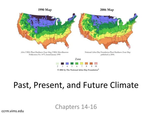
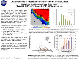
Simulations of the Present and Future Precipitation Climate of the Central Andes. COAWST Modelling System Training 27 August 2014 Stephen D. Nicholls and Karen I. Mohr NASA-Goddard Space Flight Center. Definition a nd objectives.

E N D
Simulations of the Present and Future Precipitation Climate of the Central Andes COAWST Modelling System Training 27 August 2014 Stephen D. Nicholls and Karen I. Mohr NASA-Goddard Space Flight Center
Definition and objectives • Precipitation climate: Diurnal cycle, total rainfall, distribution • Motivation: GCMs and CORDEX lack temporal and spatial resolution. Central Andes very sensitive to climate change. • Objectives: • Determine stability and feasibility of COAWST as a regional climate model • Run year-long COAWST simulation to gain precipitation climate “snapshots”
Model Configuration (1) WRF • COAWST rev 727 (May 2012) • WRF • 2 domains (27, 9 km) • 61 vertical levels • Model top: 50 hPa • ROMS • 1 domain (~10 km) • 16 vertical levels • Open boundaries • No SWAN • Current and future wave climate? • Coupling: WRF 1 <> ROMS ROMS
Model Configuration (2) WRF • Lateral boundaries: • Atm, Ocn: MIROC5 (0.7°) • Tides: OSU • Time steps: • WRF: 60 sec, 20 sec • ROMS: 10 sec • Coupling: 30 mins • Free-running simulation • Modified landuse • USGS = 1991, MODIS = 2003 • Forest and glacier loss ROMS
Simulations • All simulations for entire year (Oct-Oct) • “Current” climate (2003-04) • WRF uncoupled, WRF-ROMS coupled • Future climate (2031-32, 2059-60, 2087-88) • Two parts • RCP comparisons (RCP 4.5, 6.0, 8.5) • Year comparisons (RCP 6.0)
Current Climate: Convection • Cumulus parameterization (Kain-Fritsch) off domain 2 • Over-generation of rain when active • Model and parameterization at 9 km??
Current Climate • Precipitation + SST • Impacts on atmosphere • Precipitation impacts in Andes
Current Climate: Precipitation + SST TRMM = Tropical Rainfall Measuring Mission Daily 3B42 ECM03 = ECMWF interim analysis WMH03 = WRF with MIROC5 input, no ROMS CMH03 = WRF with MIROC5 input, coupled to ROMS
Current Climate: Precipitation + SST TRMM = Tropical Rainfall Measuring Mission Daily 3B42 ECM03 = ECMWF interim analysis WMH03 = WRF with MIROC5 input, no ROMS CMH03 = WRF with MIROC5 input, coupled to ROMS
Current Climate: Precipitation + SST TRMM = Tropical Rainfall Measuring Mission Daily 3B42 ECM03 = ECMWF interim analysis WMH03 = WRF with MIROC5 input, no ROMS CMH03 = WRF with MIROC5 input, coupled to ROMS
Current Climate: Precipitation + SST TRMM = Tropical Rainfall Measuring Mission Daily 3B42 ECM03 = ECMWF interim analysis WMH03 = WRF with MIROC5 input, no ROMS CMH03 = WRF with MIROC5 input, coupled to ROMS
Current Climate: Precipitation + SST TRMM = Tropical Rainfall Measuring Mission Daily 3B42 ECM03 = ECMWF interim analysis WMH03 = WRF with MIROC5 input, no ROMS CMH03 = WRF with MIROC5 input, coupled to ROMS
Atmospheric impacts: θe and Sfc Winds • Plots: • Top (Oct) • Bottom • (June) • Ocean upwelling • Decreased instability
Andes Diurnal Cycle • No change to distribution, but changes in average precip • ∆Precip days • Cuzco -9 • Sajama +6 • Sucre +21 • Tuni -11
Future Climate • Precipitation • Precipitation impacts in Andes
Future Climate: Precipitation CMH03 = WRF-ROMS simulation from 2003, with historical MIROC5 input CMR6031 = WRF-ROMS simulation from 2031, with MIROC5 RCP 6.0 input CMR6059 = WRF-ROMS simulation from 2059, with MIROC5 RCP 6.0 input CMR6087 = WRF-ROMS simulation from 2087, with MIROC5 RCP 6.0 input
Future Climate: Precipitation CMH03 = WRF-ROMS simulation from 2003, with historical MIROC5 input CMR6031 = WRF-ROMS simulation from 2031, with MIROC5 RCP 6.0 input CMR6059 = WRF-ROMS simulation from 2059, with MIROC5 RCP 6.0 input CMR6087 = WRF-ROMS simulation from 2087, with MIROC5 RCP 6.0 input
Future Climate: Precipitation CMH03 = WRF-ROMS simulation from 2003, with historical MIROC5 input CMR6031 = WRF-ROMS simulation from 2031, with MIROC5 RCP 6.0 input CMR6059 = WRF-ROMS simulation from 2059, with MIROC5 RCP 6.0 input CMR6087 = WRF-ROMS simulation from 2087, with MIROC5 RCP 6.0 input
Future Climate: Precipitation CMH03 = WRF-ROMS simulation from 2003, with historical MIROC5 input CMR6031 = WRF-ROMS simulation from 2031, with MIROC5 RCP 6.0 input CMR6059 = WRF-ROMS simulation from 2059, with MIROC5 RCP 6.0 input CMR6087 = WRF-ROMS simulation from 2087, with MIROC5 RCP 6.0 input
Future Climate: Precipitation CMH03 = WRF-ROMS simulation from 2003, with historical MIROC5 input CMR6031 = WRF-ROMS simulation from 2031, with MIROC5 RCP 6.0 input CMR6059 = WRF-ROMS simulation from 2059, with MIROC5 RCP 6.0 input CMR6087 = WRF-ROMS simulation from 2087, with MIROC5 RCP 6.0 input
Future Andes Diurnal Cycle • Diurnal cycle fairly robust • Temp precip “bump” • Cuzco, Sajama • Upper air • ∆Precip days (2087-2003) • Cuzco -12 • Sajama -9 • Sucre -16 • Tuni -20
Remaining questions • WRF-ROMS runs lean toward a La Niña pattern • MIROC issue or ROMS bias or WRF radiation issue or forcing issue • Convective parameterization: No parameterization works well short term, but less effective long term • Potential issues with model configuration? • Eg. WRF model top, etc. • Problem with two-way interaction when both WRF grids not coupled to ROMS. • Model buffer zones • Future work
Thanks for you attention and time!!! • Questions, comments???
Landcover/landuse change • Modified raw MODIS landcover (WPS_geog) • Landcover change rates • Amazon (AZ) = ↓7000.0 km2/yr (Davidson et al. 2012) > 2003 • Atlantic Forest (AF): ↓0.343%/yr (Ribieroet al. 2009) • Chaco (CH): ↓2.2%/yr (Zak et al. 2004) • Tropical Glaciers (TG): 0.6785% (Slayback and Yegar 2006) • Forest (#1-5 vary) to cropland (#12) • Ice (#25) to tundra (#20)
WRF Parameterizations • Microphysics – Goddard • Longwave Rad. – New Goddard • Shortwave Rad. – New Goddard • Surface layer – Eta similarity • Land Surface – NOAH • Boundary Layer – Mellor-Yamada-Janjic • Cumulus – Kain Fritsch (Turned off domain 2)
ROMS Parameterizations #define MCT_LIB # undef BULK_FLUXES # define ATM2OCN_FLUXES # define ANA_SSFLUX # undef LONGWAVE_OUT #undef MY25_MIXING # define KANTHA_CLAYSON # define N2S2_HORAVG #define RADIATION_2D /* ok */ #define RAMP_TIDES /* ok */ #define SSH_TIDES /* ok */ #define ADD_FSOBC /* ok */ #define ANA_FSOBC /* ok */ #define UV_TIDES /* ok */ #define ADD_M2OBC /* ok */ #define ANA_M2OBC /* ok */ #define EAST_FSCHAPMAN #define EAST_M2FLATHER #define EAST_M3RADIATION #define EAST_TRADIATION /* #define ROMS_MODEL # define WRF_MODEL # define MCT_INTERP_OC2AT #define UV_ADV #define UV_COR #define UV_VIS2 #define MIX_S_UV #define TS_U3HADVECTION #define TS_C4VADVECTION #undef TS_MPDATA # define UV_LOGDRAG #define DJ_GRADPS #define TS_DIF2 #define MIX_GEO_TS #define SALINITY #define SOLVE3D #define SPLINES #undef AVERAGES #define NONLIN_EOS #define MASKING
Model Error • Energy norm • Scale-adjusted perturbations (model-obs) of U, V, W, P, T, and Q) • Despite SST errors and free running, model simulation remains stable