Download
1 / 1
10 likes | 79 Views
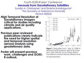
This poster at the Fourth GOES-R Users’ Conference highlights the importance of high temporal resolution of geostationary imagers for aerosol analysis. It discusses challenges, previous work, and the GOES-R outlook with a focus on climate and air quality applications. Time series data from GOES-8 for Los Fieros, Bolivia, is presented to illustrate the need for improved spatial and temporal resolution in aerosol analysis.

E N D
Fourth GOES-R Users’ Conference: Aerosols from Geostationary SatellitesSundar A. Christopher1 and Shobha Kondragunta21The University of Alabama in Huntsville2NOAA-NESDIS High Temporal Resolution of Geostationary imagers critical for studies including climate and air quality applications. Previous peer reviewed publications clearly indicate the need for higher spatial and temporal resolution aerosol analysis using geostationary data. Poster will present previous work, challenges and GOES-R outlook. Figure 1. Time series (July 1- Sep 15, 1998) of retrieved GOES-8 aerosol optical thickness from 1344-1944 UTC for Los Fieros, Bolivia. The different symbols denote different time of measurements