Download
1 / 6
60 likes | 206 Views
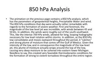
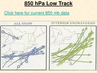
850 hPa Low Track. Click here for current 850 mb data. 850 hPa Low (Blizzard of 2006). Heaviest snow band over the I-95 corridor at this time. Rates of 2 to 5 inches per hour. Phase 3 of the storm (wrap around). 850 hPa Low Strength and Track.

E N D
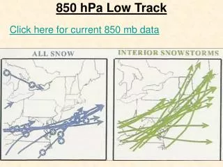
850 hPa Low Track Click here for current 850 mb data
850 hPa Low (Blizzard of 2006) • Heaviest snow band over the I-95 corridor at this time. Rates of 2 to 5 inches per hour. Phase 3 of the storm (wrap around).
850 hPa Low Strength and Track The strength of the upper air low, the 850hPa (mb) low, is one of the factors that aides in the rapid development of a coastal low. Thus, an intensifying 850 mb low, or an already strong 850 mb low, greatly aides in the development of heavy snowfall near the Philadelphia region. This is especially true in Miller B systems. For a Miller B storm to be deemed a heavy snow event for Philadelphia it is crucial that the 850 low goes through a rapid intensification cycle. However, even more important than strength is track. The 850 hPa is best to the south of Philadelphia, yet north the NC/VA border moving in an easterly direction.
Table V HINTS FOR FORECASTING MODERATE TO HEAVY SNOW (S+) 850 mb • About 1.5 degrees latitude to the left of the track of the low (60 to 240 nm) • When cooling occurs in the rear quadrant of the low during early stages of development, heavy snow occurs • Heavy snows occur more frequently with lows that generally move NE • Heavy snows less rare with lows dropping south of east (e.g. Alberta Clipper or Manitoba Mauler, Saskatchewan Screamer) • -5 C isotherm bisects the heavy snow • -2C to -8 C for moderate snow • >5 C of WAA moving into area of interest (overrunning)
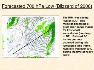
Surface Low, 500mb Low, 850 Low, and 700 Low-- Merge February 11-12, 2007