Download
1 / 35
350 likes | 481 Views
Lower Lakes and Murray River Modelling (Virtual Weir Presentation / Discussion). Canberra 11 February 2009. To be Discussed. Existing Modelling: RMA (2D) and ELCOM (3D) Modelling of Virtual and Partial Weir Simulations Model Setup Model Validation Model Results & Animations

E N D
Lower Lakes and Murray River Modelling(Virtual Weir Presentation / Discussion) Canberra 11 February 2009
To be Discussed • Existing Modelling: • RMA (2D) and ELCOM (3D) Modelling of Virtual and Partial Weir Simulations • Model Setup • Model Validation • Model Results & Animations • Model Uncertainty • Empirical Calculations: • Destratification / Richardson Number Calculations • Seiche Volumes
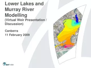
Model Setup/Extents • RMA 2D (Blue) : All areas upstream of Tidal Barrages & Downstream of Lock 1, Lake Albert disconnected • ELCOM 3D (Green) : From Pomanda Island (upstream of weir location) to Murray Bridge • RMA simulation executed first, then results fed to ELCOM (U/S & D/S Boundaries)
Model Validation • Validation period 1/1/2008 – 14/7/2008 • Objectives: • Best match observed hydrodynamics (WL) and salinity • Ensure key processes appropriately represented • Understanding of model uncertainty • Key Uncertainties • Additional salt load along length of River • Additional irrigation demands / groundwater losses?
2 yr “Prognostic Simulations” • Examining what may happen in the future, given continuing high net evaporation (1982) levels, and variations in the South Australia’s border allocation (Border Allocations of 696, 796 and 896 GL/yr), through to the end of 2010. • Simulations aimed at maintaining Lake Level at -1.3mAHD. • Salt water introduced through Goolwa Barrage in October 2009. • Stop logs positioned by-monthly based on water level balance calculation.
Comparison at End 2010 696 GL/yr 796 GL/yr 896 GL/yr
Uncertainty • Model can still be improved • Validation only currently till Mid July 2008 (no destratification period) • No validation data for low level and high salt available • Uses 1 year (2007) wind (cannot predict future wind conditions) • Wind spatially homogenous
Partial Closure Weir Simulations • No Weir • 1100m Gap • 700m Gap • 300m Gap • 100m Gap
Pomanda Island Lake Alexandrina N River Channel Pomanda Embayment Bathymetry