Download
1 / 22
220 likes | 440 Views
The Inland Extent of Lake-Effect Snow (LES) Bands . Joe Villani NOAA/NWS Albany, NY Michael L. Jurewicz, Sr. NOAA/NWS Binghamton, NY Jason Krekeler State Univ. of NY, Albany, NY 18 th GLOMW, Toronto, Ontario March 22-24, 2010. Outline. Motivation Goals Methodology Results

E N D
The Inland Extent of Lake-Effect Snow (LES) Bands Joe Villani NOAA/NWS Albany, NY Michael L. Jurewicz, Sr. NOAA/NWS Binghamton, NY Jason Krekeler State Univ. of NY, Albany, NY 18th GLOMW, Toronto, Ontario March 22-24, 2010
Outline • Motivation • Goals • Methodology • Results • Case Studies • Ongoing / Future Work
Motivation • Considerable research has been devoted to LES processes and forecast issues over the last 2-3 decades • However, among these, comparatively little attention has been given to inland extent
Goals • To identify atmospheric parameters that commonly have the most influence on a LES band’s inland penetration • Use these results in the forecast process to improve: • The quality/detail of information given to the public (nowcasting) • The NWS Watch/Warning/Advisory program
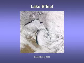
Satellite Depiction of an Intense Band all the way to Albany, NY Upstream moisture sources Well developed single band from Lake Ontario to the Hudson Valley
Methodology/Data Sources • Examined 20 LES events across the Eastern Great Lakes (Erie/Ontario) during the 2007-2010 time frame • For each event, parameters were evaluated at 6-hour intervals (00, 06, 12, and 18 UTC), using the NAM12 and RUC models, as well as BUF/ALY soundings • Events averaged 24-30 hours in length • Wind regimes varied from a mean flow of 250-260 (WSW-ENE oriented bands) to 300-320 (NW-SE oriented bands)
Methodology (Continued) • LES bands’ inland penetrations (miles) calculated from radar mosaics, and a distance measuring application • Data points • Locations both inside bands and on their peripheries were used (north, south, and just downstream of the band) • Data stratified based on location relative to band
Example of Data Points Points in and near the LES band ALY sounding BUF sounding
Strategy to Determine “Best” Parameters • Used statistical correlations to determine the most influential factors for inland extent • Overall, locations relative to bands made little difference in the correlations (within the bands vs. north or south) • A few notable exceptions
Statistics • Best correlators to inland extent (all points together): • Multi-lake connection (0.75) • 850/700 mb Lake-air differentials (-0.65) • Mixed-layer speed shear (0.27) • Mixed-layer directional shear (-0.23)
Results (Continued) • Also a few healthy correlators in locations outside of the bands: • Points south of the band: • Height of capping inversion (-0.4) • Mixed-layer speed shear (0.35) • Points north of the band: • Mixed-layer directional shear (-0.4) • Surface winds (0.3)
Brief Case Study Examples • Both events featured 260-270 mean flow single bands • 8 January 2009 • Only small inland penetration • 16 January 2009 • Much greater inland extent
8 January – Radar + 1 km Shear Strong mixed-layer flow - 30 to 40 kt
8 January – BUF Sounding - Lake to 850 mb Delta T of 13C - Lake to 700 mb Delta T of 22C - Only conditionally unstable LR’s
16 January – Radar + 1 km Shear Weaker mixed-layer flow - 10-20 kt Strong mixed-layer flow – 30 to 40 kt
16 January – BUF Sounding - Lake to 850 mb Delta T of 26C - Lake to 700 mb Delta T of 37C - Much steeper LR’s
Take-Home Points • Environments that promoted greater inland extent of LES bands seemed to feature these characteristics: • Strong, well aligned flow in the mixed layer (especially north of the band) • Only conditional terrestrial instability • Moderately to extremely unstable cases tended to produce disorganized/cellular structures, confined closer to the shoreline
More Summary Points • South of the band: • Stable, sheared environments seemed favorable for inland extent • Cold low-level inflow into the band • Lower cap/EL • Multi-Lake connection (MLC) is another factor that strongly related to inland extent
Ongoing / Future Work • Further develop an algorithm/equation that provides an estimate of inland extent, based on favorably correlated parameters • To be used in cases where LES band development seems likely • Has already been tested on some of our cases, with favorable results • Individual/composite plots for MLC patterns • MSLP/850/700 low tracks • Based on flow regimes
Present/Future Work (Continued) • Perhaps better delineate significant thresholds for strongly correlated parameters • Single banded vs. Multi-banded cases
The End Questions ??