Download
1 / 51
510 likes | 624 Views
COMM3PR1 Managing Sustainable Communication Infrastructure Information with the Geospatial Server. Francois Valois, Product Manager. Agenda. Why create the Bentley Geospatial Server? What is the Bentley Geospatial Server? How does Bentley Comms work with the Bentley Geospatial Server?.

E N D
COMM3PR1 Managing Sustainable Communication Infrastructure Information with the Geospatial Server Francois Valois, Product Manager
Agenda • Why create the Bentley Geospatial Server? • What is the Bentley Geospatial Server? • How does Bentley Comms work with the Bentley Geospatial Server?
The Information Explosion Era • Information is exploding->becoming virtually impossible to manage without dedicated tools • Unmanaged information-> constantly risking poor decision making • Data formats, data quality, metadata must be managed • Two types of information must be managed: • Structured information (fixed schema) • Unstructured information (no fixed schema)
The Information Explosion Era • 80 percent of business is conducted on unstructured information (Gartner Group). • 85 percent of all data stored is held in an unstructured format (Butler Group). • Unstructured data doubles every three months (Gartner Group). Source: DCI Portals, Collaboration and Content Management conference in Miami, Zach Wahl from the Project Performance Corporation
Problems • Inefficiency in information management • Redoing the same work because users cannot quickly find the accurate as-built • Spending too much time/money looking for information • Receiving too much information from different sources in different formats and ending up using e-mails as a backup system • Sometimes people re-organize their projects and it breaks all the references that have been created • Once a project is completed we have no way to archive this data in its original form to easily find it when our decisions are contested • We have a large, distributed team and we never know what is the latest version of a particular document • We sometimes make decisions without all the right information at the right time, even if this information exists in the organization • We don’t have a single source of truth for all our projects
Problems • Different systems can’t share information • Engineers can’t get data from the corporate spatial database • Engineers can’t feed the corporate spatial database directly • People can’t share part, or all of the engineering information with other departments
Problems • Inefficiency in project management • No way of keeping track of project status • Sometimes people change a design and you don’t get notified until it is too late, if you get notified at all • You have no way to evaluate different alternatives easily • You need to work on the same project for weeks before other people are allowed to see it • You don’t know what project data was sent to a sub-contractor and when • You have problems getting everyone to always use the correct MicroStation workspace
Problems • Inefficiency in the management of historical data • You have no way to produce historical maps and reports to comply with governmental regulation • You have no way to keep track of an asset over its full lifecycle • Producing historical maps/reports is too costly • Inefficiency in the field • You have no digital tool to support work in the field • You have no good/fast internet access in the field and you need to annotate or edit your designs/maps in the field
Problems • Cost of printing is too high • You are spending too much money on paper for printing plans and maps • You are trying to reduce the environmental impact of printing in your organization
What is the Bentley Geospatial Server? • Bentley Geospatial Server = Enterprise GIS • Using a unique Federated Information Management approach • The idea is simple: • Index rather than convert • Find rather than search • Allows managing, indexing, editing, and plotting of : • Structured information, fixed schema • Spatial Database, DGN/XFM, Shapefile, … • Unstructured information, no schema • Raw DGN, DWG, Word, PowerPoint, …
The Traditional GIS Way • Geographic Information System models the real world as features and typically works with homogenous data
The Search Engine Way Here is an example of how a search engine technology (Google in this case) works
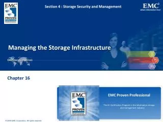
What is the Bentley Geospatial Server? • A portfolio of the following products: • ProjectWise Integration Server • Bentley Geospatial Management • ProjectWise Connector for Oracle • ProjectWise Interplot • Integrated for geospatial needs • Five Services: • Document Service • Spatial/Indexing Searching Service • Workflow Management Service • Spatial Database Service • Plotting Service
Indexes, Metadata, Settings Bentley Geospatial Server Architecture Bentley Geospatial Server Spatial Indexing/Searching Service Workflow Management Service Spatial Database Service Plotting Service Document Service Client Applications
Document service • Ability to store spatial and non-spatial files • Scalable solution • Ability to manage complex files with references • (e.g.: DGN, SHP, MXD, DWG) • CAD standards management • Multiple application integration • (e.g.: Microsoft Office, AutoCAD, MicroStation, ArcMap)
Spatial Indexing/Searching Service • Why indexing? • Find information without conversion • Fast and exact • Simple • Use the full value of data • Maintain data integrity • Using data quickly • Using many research criteria
Spatial Indexing/Searching Service • Two types of spatial indexing • Document/project extent • Allow searching document/folder using spatial extents • Document content • Allow searching document spatial (features) and non-spatial content (text)
Document/Project extent indexing • A spatial location may be: • manually defined • inherited from the parent folder • scanned from the files (auto extract and batch) • imported from an external file • calculated (for a folder and files ) • inferred from an attribute value • It can be a gradual process (as with any other meta data)
Document Content Indexing • Text indexing (Office, DGN, DWG, PDF) • Run on the server on a scheduled basis • Can be used as research criteria • Can be combined with other criteria • Feature indexing • Run on the server on a scheduled basis • Geometry and attributes are indexed • Find DGN files using spatial on non-spatial criteria on the content • Produce report • Seamless display on a map • Documenting assets
Workflow management service • Allow enforcing work processes • Workflow is a set of states (e.g. initial, design, 75% design, complete) successively traversed by an object • For each state different security can be enforced on objects stored in the system • For each state it is also possible to have specific communication enforced through emails
Spatial Database Service • Excellent Oracle database citizen • Create 100% Oracle Spatial standard data • Use Oracle Spatial metadata and coordinate systems • Use Oracle standard versioning (Workspace Manager) • No proprietary schemas, tables or fields (no MSLink) required • Implementation reviewed by Oracle Spatial team
Interoperability with Oracle Spatial Bentley Geospatial Server
Architecture Bentley GeoWeb Publisher Oracle Locator Oracle Spatial • Simultaneous Multi User Editing • Long transactions, optimistic and pessimistic locking • Time component Bentley Geospatial Server • Direct editing of Oracle Spatial databases • Full support of Oracle 10G topology model • Short transactions Bentley Geospatial Industry Applications Bentley Geospatial Desktop
Bentley Geospatial Server Bentley Geospatial Industry Applications Bentley Geospatial Desktop Bentley Geospatial Server-Oracle Spatial • Live viewing/editing • Disconnected editing • Long transaction pessimistic • Long transaction optimistic • Multi-user editing on same area • Conflict resolution • Geometry and topology support • Coordinate systems • Text, feature-linked text • Coded domains • Loading tools (DGN2SDO) • Time component support • Fully customizable – web services
Plotting Service • Complete plot management • Hard copy plot creation • Digital plot creation, storage and distribution
Utilities companies use the Bentley Geospatial Server for • Information management • Work order management • Workflow management • Disconnected spatial database editing • Organization: IRIDE Energia, Torino, Italy • Department: IT • Department focus: IT infrastructure for electric, district heating, gas and water networks • Products used: Bentley Geospatial Server, Bentley Geo Web Publisher, Bentley Map • Project: Bentley Geospatial Server and Bentley Geo Web Publisher integrated to provide a web interface for work order management as well as integration with different web services (Spatial Database Service, SAP, etc). done by Bentley Professional Services
Airports use the Bentley Geospatial Server for • Data editing and permitting management • Workflow management • Spatial database support • Collaboration among colleagues • Collaboration with external contractors • Organization: Greater Toronto Airports Authority (GTAA), Toronto, Canada • Department: Technical Data Center • Organization focus: Managing airport infrastructure data: sites (water, electric, road, runway), space (building, rental, terminal), mapping, report productions, internal web site, diffusion of base data • Products used: Bentley Geospatial Server, Bentley Geo Web Publisher, Bentley Map • Project: Owner-operator doing all the work
Mining companies use the Bentley Geospatial Server for • Data editing • Workflow management • Spatial database support • Collaboration among colleagues • Management of historical data • Organization: Mibrag, Germany • Department: Topographic survey • Organization focus: Managing mine data, surveying the mine, updating mine data, mapping, reporting • Products used: Bentley Geospatial Server, Bentley Map • Project: Bentley Professional Service and Owner-operator
Local Governments use the Bentley Geospatial Server for • Data editing project management • Workflow management • Spatial database support • Collaboration among colleagues • Organization: City of Montreal, Canada • Department: Geospatial • Organization focus: maintain base geospatial data for other departments. • Products used: Bentley Geospatial Server, Bentley Map • Project: Water network data update - Bentley Professional Services provided installation and configuration support
How does Bentley Comms work with the Bentley Geospatial Server?
Bentley Comms and Bentley Geospatial Server • Document Service • Comms is capable of storing and retrieving documents • Spatial Indexing and Searching Service • Bentley Geospatial Server is capable of indexing the extent of any Comms DGN • Bentley Geospatial Server can is capable of indexing the Comms features having graphics (e.g.: cable) • Plotting Service • Comms DGN can be plotted
Bentley Comms and Bentley Geospatial Server • Workflow Service • Comms is fully integrated with Bentley Geospatial Server workflow service • Spatial Database Service • Comms support the following: • Live Database Document • Optimistic locking • Pessimistic locking • Comms doesn’t support yet: • Disconnected database documents • Time component
What’s coming in the future • Document Service • Delta file transfer • Spatial Indexing and Searching Service • Simplified searches • Better background map • Using Bentley GeoWeb Publisher Engine • Better performance • More formats • Live Oracle Spatial, Live DGN, SHP, WMS
What’s coming in the future • Spatial Database Service • Oracle GeoRaster • Oracle Cartographic Text
What’s coming in the future • Web • Standard OGC: WFS, WMS • Standard IT: SOAP, WSDL • Geospatial Web Part
SOA Desktop Web Browser Mobile Enterprise Service Bus Service Orchestration (BPEL) SOAP/WSDL Geospatial Federated System WMS/WFS WMS/WFS GIS & Engineering Resources Other resources Spatial DB Index Documents ERP, Work Mngt Maps SAP, Maximo, … Ex: PODS APDM APDM