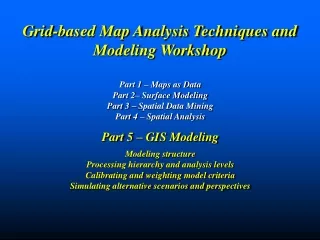
Grid-based Map Analysis Techniques and Modeling Workshop
Explore grid-based map analysis techniques and modeling in a comprehensive workshop focusing on campground and transmission line suitability. Learn about criteria evaluation, model logic communication, decision support systems, model calibration, and weighting using GIS tools. Discover how to simulate scenarios, analyze spatial data, and generate optimal path corridors.

Grid-based Map Analysis Techniques and Modeling Workshop
E N D
Presentation Transcript
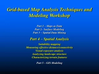
Grid-based Map Analysis Techniques and Modeling Workshop Part 1 – Maps as Data Part 2– Surface Modeling Part 3 – Spatial Data Mining Part 4 – Spatial Analysis Part 5 – GIS Modeling Modeling structure Processing hierarchy and analysis levels Calibrating and weighting model criteria Simulating alternative scenarios and perspectives
Campground Suitability Model (Demo) …evaluate a GIS model for Campground Suitability with the following criteria— • Prefer gentle slopes • Prefer near roads • Prefer near water • Prefer good views of water • Prefer westerly aspect …can’t be too close to water or too steep (legal constraints) (Berry)
What if…thinking with maps Decision Support Systems Framework An Interactive Map links a map’s logic (flowchart) to its processing script (commands) and base data. A user can query the logic (click on boxes and maps) and modify calibrations/weights for alternate scenarios— (See MapCalc Applications, “Identifying Campground Suitability” for more information) (Berry)
Existing Powerline Goal– identify thebest route for an electric transmission linethat considers various criteria for minimizing adverse impacts. Proposed Substation Houses • Criteria – the transmission line route should… • Avoid areas ofhigh housing density • Avoid areas that arefar from roads • Avoid areaswithin or near sensitive areas • Avoid areas of highvisual exposure to houses Roads Sensitive Areas Elevation Houses Transmission Line Routing Model (Berry)
Avoid areas of… High Housing Density Far from Roads In or Near Sensitive Areas High Visual Exposure Model logic is captured in a flowchart where the boxes represent maps and lines identify processing steps leading to a spatial solution Routing Model Flowchart(Model Logic—components) (Berry)
Step 1 Identify overall Discrete Preference (1-9 rating) Step 2 Generate an Accumulated Preference surface from the starting location to everywhere Step 3 Step 2 Step 1 Step 3 Identify the Most Preferred Route from the end location Routing Model Flowchart(Model Logic—maps) Model logic is captured in a flowchart where the boxes represent maps and lines identify processing steps leading to a spatial solution (Berry)
AVOID Least Preferred Most ATTRACT EXCLUDE (0) …average of the four individual preference maps for overall preference at each cell Step 1Discrete Preference Map … identifies the relative preference of locating a transmission line at any location throughout a project area considering multiple criteria (Berry)
Splash Algorithm – like tossing a stick into a pond with waves emanating out and accumulating costs as the wave front moves Step 2Accumulated Preference Map … identifies the preference to construct the preferred transmission line from a starting location to everywhere in a project area (Berry)
Preferred Route Preferred Route Step 3Most Preferred Route … the steepest downhill path over the accumulated preference surface identifies the most preferred route — minimizes areas to avoid (Berry)
…technique combines the Start and End preference surfaces to identify the overall preference for “forcing” routes off the optimal path The alternative corridors are derived by considering the top 5 percent of the best routes within the project area Generating Optimal Path Corridors Pinch Point (Berry)
Rankings Weights …but what is high housing density and how important is it? …etc? Siting Model Flowchart (Calibrating and Weighting) Model logic is captured in a flowchart where the boxes represent maps and lines identify processing steps leading to a spatial solution Avoid areas of… High Housing Density Far from Roads In or Near Sensitive Areas High Visual Exposure (Berry)
1 for 0 to 5 houses …group consensus is that low housing density is most preferred Calibrating Map Layers(Relative Preferences) Model calibration refers to establishing a consistent scale from 1 (most preferred) to 9 (least preferred) for rating each map layer The Delphi Process is used to achieve consensus among group participants. It is a structured method involving iterative use of anonymous questionnaires and controlled feedback with statistical aggregation of group response. (See www.innovativegis.com/basis, select Column Supplements, Beyond Mapping, September 03, Delphi) (Berry)
…group consensus is that housing density is very important (10.38 times more important than sensitive areas) HD * 10.38 R * 3.23 SA * 1.00 VE * 10.64 The Analytical Hierarchy Process (AHP) establishes relative importance among by mathematically summarizing paired comparisons of map layers’ importance. Weighting Map Layers(Relative Importance) Model weighting establishes the relative importance among map layers (model criteria) on a multiplicative scale (See www.innovativegis.com/basis, select Column Supplements, Beyond Mapping, September 03, AHP) (Berry)
The model is run using three different sets of weights for the map layers— …to generate three alternative routes (draped over Elevation) Generating Alternate Routes (changing weights) (Berry)
Grid-based Map Analysis Techniques and Modeling Workshop Part 1 – Maps as Data Part 2– Surface Modeling Part 3 – Spatial Data Mining Part 4 – Spatial Analysis Part 5 – GIS Modeling
Online Books Software More on Spatial Analysis and Modeling www.innovativegis.com/basis (Berry)