Download
1 / 1
10 likes | 250 Views
Solar, IR, rain, U, T, Q Heat, mass & momentum flux, ε. 3-day composite SST for 30-Aug-2002. U, T, Q Heat, mass & mom. flux, ε Waves. July 2002. 23m. Waves T, S Heat, mass mom. flux, ε. COAMPS CBLAST, 3km, 91x91. Irradiance. MVCO. 15m. Irradiance. July 2002 mean. 9 km. MVCO.

E N D
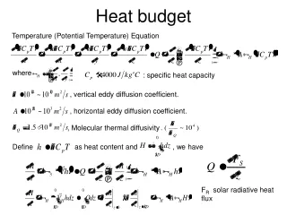
Solar, IR, rain, U, T, QHeat, mass & momentum flux, ε 3-day composite SST for 30-Aug-2002 U, T, QHeat, mass & mom. flux, εWaves July 2002 23m WavesT, S Heat, mass mom. flux, ε COAMPS CBLAST, 3km, 91x91 Irradiance MVCO 15m Irradiance July 2002 mean 9 km MVCO Aircraft 27 km, 151x121x30 ASIT Operational forecasts commence mid-July, 2003 K Nantucket SODAR M2 displacement ellipses from ADCIRC COAMPS 72-hour forecast is generated every 12 hours at ARL.HPC.mil and transferred to IMCS where ROMS runs for the same forecast cycle. Real-time validation is available using CODAR on Nantucket (operational after July 7, 2003). ROMS forecasts will be factored into the deployment strategy for drifting instrument strings providing Lagrangian observations of evolving mixed-layer. ASIMET moorings with ocean T(z) and ADCP 3-D Mooring Remote Sensing CTD temperature section between ASIT and mooring-A, late July 2001. Vigorous tidal mixing generates a region of perpetually cold SST on the eastern flank of the Nantucket Shoals Observed Modeled Modeling the Summertime Heat Budget of Southeast New England Shelf Waters John Wilkin and Lyon Lanerolle Institute of Marine and Coastal Sciences, Rutgers University, New Brunswick, N.J. wilkin@marine.rutgers.edu http://marine.rutgers.edu/~wilkin/wip/cblasthttp://ocean-modeling.org CBLAST: Coastal Boundary Layers and Air-Sea Transfer Regional Ocean Modeling System (ROMS) numerical features Mean circulation and heat budget Summary Tides significantly affect the mean circulation and heat budget. Lateral heat transport is large in much of the region, including near MVCO, and will need to be considered in the analysis of ASIT heat budgets. Wind-driven upwelling circulation contributes to the heat budget southwest of Martha’s Vineyard. A 1-D heat balance occurs near the B-A-C ASIMET mooring sites, and these data will be used for evaluation of model turbulent closures. Circulation around the Nantucket Shoals is augmented by strong tidal rectified cyclonic flow that carries water northward into Vineyard Sound through Muskegat Channel (between Nantucket and the Vineyard). The open boundary climatology imposes a south and westward flow from the Gulf of Maine, through Great South Channel and around Nantucket Shoals. The ONR CBLAST-Low program focuses on air-sea interaction and coupled atmosphere/ocean boundary layer dynamics at low wind speeds where processes are strongly modulated by thermal forcing. (There is a companion CBLAST-Hurricane program.) • Split-explicit, free-surface, hydrostatic, primitive equation model [1,2] • Generalized, terrain-following vertical coordinates • Orthogonal curvilinear, horizontal coordinates, Arakawa C-grid • 3rd- and 4th-order advection and time-stepping; weighted temporal averaging; reduced pressure gradient and mode-splitting error • Simultaneous conservation and constancy preservation for tracer equations in combination with evolving coordinate system due to free-surface [2] • High-order accurate continuous, monotonic reconstruction of vertical gradients • Adjoint and tangent-linear implemented; 4-D variational assimilation under test • MPI and OpenMP shared and distributed memory parallel F-90 code • All input/output via NetCDF • NPZD biology; EcoSim bio-optics; Community sediment transport model, Lagrangian floats • Vertical turbulence closure options • Mellor-Yamada level 2.5 • K-profile parameterization (KPP) surface and bottom boundary layers [3] • Generalized Length Scale scheme [4,5]: Eddy viscosity and diffusivity are the product of a non-dimensional stability function, TKE, and length scale. Stability functions are the result of various 2nd-moment closures. TKE and length scales are calculated by dynamic (as in k- or M-Y) or algebraic formulations. GLS encompasses k-, k- and M-Y in a single code. Southwest of Martha’s Vineyard, and within Vineyard Sound, winds drive eastward depth averaged flow. Turbulence and mean flow observations are being used to quantify the turbulent kinetic energy, momentum, mass, and heat budgets in the oceanic mixed-layer and atmospheric boundary layer. The field program is centers on the Martha’s Vineyard Coastal Observatory (MVCO) and Air-Sea Interaction Tower. Tidal phase eddies transport cold tidally-mixed Nantucket Shoals water into Vineyard Sound, and warmed VS water toward MVCO. Observational assets deployed in July/August of 2002 and 2003 include in situ observations of vertical fluxes and mixing rate profiles from fixed towers and moorings, satellite and aircraft remote sensing, and measurements of small-scale and breaking waves. Time series of the heat budget (below) in a box near MVCO shows half the air-sea flux goes to warming the water column, and half is removed by lateral divergence. Air-sea flux (Qnet) is greatest east of Vineyard Sound where SST is cold, but is largely balanced by divergence due to tidal mixing. Ocean temperature increase (storage) is largest south of The Islands, primarily due to surface heating. Horizontal divergence is small in the region of the B-C ASIMET moorings - indicating a region of approximate 1-D vertical heat balance suited to evaluating ROMS vertical turbulence closures. ROMS CBLAST configuration 1 km horizontal resolution20 s-levels (stretched toward surface) The time mean advection cools the box at, on average, 200 W/m2. The net “eddy” divergence (u’T’) warms the MVCO region at about 150 W/m2. Episodic positive divergence (cooling) events briefly arrest the warming trend. Coherent structures (Fanbeam) Heat & mom. fluxU(z), Waves(ACDP) • Surface forcing: • Heat and momentum fluxes from bulk formulae [6] with model SST, observed downward long-wave at MVCO, and Tair, pair, rel. humidity, U10, V10, and short-wave radiation from 3 km resolution nested COAMPS 6--36 hr forecast CBLAST-Low Observing System: • Open boundary conditions: • Inflow climatology [7] + outflow radiation [8] on T,S, u, vClimatology, tides [9], radiation (gh) on and depth average u,v • 160 x 380 x 20 grid requires approximately 2 CPU mins per model day on 16-processor HP/Compaq Qualitative comparison to subsurface validation data (below) shows realistic vertical stratification and mixed layer depths. In 2003, an array of 5 subsurface moorings between ASIT and ASIMET mooring-A will enable validation of the modeled evolution of the diurnal mixed layer. Tidal stirring CBLAST Modeling using ROMS References [1] Haidvogel, D.B., H. Arango, K. Hedstrom, A. Beckmann, P. Rizzoli and A. Shchepetkin, 2000: Dyn. Atm. Oceans, 32, 239-281. [2] Shchepetkin, A., and J.C. McWilliams, 1998: Monthly Weather Review, 126, 1541-1580. [3] Large, W., J. McWilliams, and S. Doney, 1994: Rev. Geophys., 32, 363-403. [4] Umlauf, L. and H. Burchard. A generic length-scale equation for geophysical turbulence models, J. Mar. Res., accepted 2003. [5] Warner, J., Sherwood, C., Butman, B., Arango, H., Signell, R., Implementation of a generic length scale turbulence closure in a 3D oceanographic model." Ocean Modelling, submitted. [6] Fairall, C., E. Bradley, D. Rogers, J. Edson, and G. Young, 1996: JGR, 3747-3764. [7] Bi-monthly regional climatology provided by C. Naimie, Dartmouth University [8] Marchesiello, P., J.C. McWilliams, and A. Shchepetkin, 2001: Ocean Modelling, 3, 1-20. [9] Luettich, R. A., Westerink, J. J., and Scheffner, N. W., 1992: ADCIRC: An advanced three-dimensional circulation model for shelves, coasts, and estuaries, Tech. Report DRP-92-6, U.S. Army Engineer Waterways Experiment Station, Vicksburg, MS. Precise observations of air-sea fluxes and turbulent mixing from CBLAST are ideal for evaluating the suite of ocean model vertical turbulence closure schemes implemented in ROMS. This comparison will be possible provided the model captures the essential features of the ocean heat budget on diurnal to several day time-scales, and spatial scales of order 1 km. Modeling complements the interpretation of the field observations by quantifying unobserved lateral transport and mixing of heat.