Characteristics of Raster Data
330 likes | 1.24k Views
Characteristics of Raster Data. Longley et al. , 2001. Geographic Information Systems and Science . Wiley. Spatial Data Models. How do we represent spatial information in a computer? The rules to convert real geographical variation into discrete objects. Spatial Data Models.

Characteristics of Raster Data
E N D
Presentation Transcript
Characteristics of Raster Data Longley et al., 2001. Geographic Information Systems and Science. Wiley. Spatial Data Models
Spatial Data Models • How do we represent spatial information in a computer? • The rules to convert real geographical variation into discrete objects. Spatial Data Models
Spatial Data Models Spatial Data Models
Spatial Data Models Davis, B.E., 2001. GIS: A Visual Approach (2nd ed.). Albany, NY: OnWord Press. Spatial Data Models
Spatial Data Models Aronoff, 1993. Geographic Information Systems: A Management Perspective. Ottawa: WDL Publications. Spatial Data Models
The Vector Data Model • Feature Representation • points • vertices • nodes • label points • lines • lines • arcs • areas • polygons Davis, B.E., 2001. GIS: A Visual Approach (2nd ed.). Albany, NY: OnWord Press. Spatial Data Models
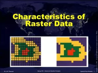
The Raster Data Model • Feature Representation • all geographic features - points, lines, areas - are represented by grid cells • grid resolution - the minimum linear dimension of the smallest unit of geographic space sampled Davis, B.E., 2001. GIS: A Visual Approach (2nd ed.). Albany, NY: OnWord Press. Spatial Data Models
Raster Data Layers Lo & Yeung, 2002. Concepts & Techniques of Geographic Information Systems. Prentice-Hall. Spatial Data Models
Field representation Object representation The Raster Data Model http://www.awi-bremerhaven.de/GEO/Marine_GIS/Principles_GIS.htm Spatial Data Models
Raster Resolution 30 m resolution 3 m resolution Spatial Data Models 0.6 m resolution
Raster Resolution Davis, B.E., 2001. GIS: A Visual Approach (2nd ed.). Albany, NY: OnWord Press. Spatial Data Models
Raster Resolution 30 m resolution 625 cells 3 m resolution 62,500 cells Spatial Data Models
Raster Advantages Davis, B.E., 2001. GIS: A Visual Approach (2nd ed.). Albany, NY: OnWord Press. Spatial Data Models
Raster Disadvantages Davis, B.E., 2001. GIS: A Visual Approach (2nd ed.). Albany, NY: OnWord Press. Spatial Data Models
Vector Advantages Davis, B.E., 2001. GIS: A Visual Approach (2nd ed.). Albany, NY: OnWord Press. Spatial Data Models
Vector Disadvantages Davis, B.E., 2001. GIS: A Visual Approach (2nd ed.). Albany, NY: OnWord Press. Spatial Data Models
Vector the location of each vertex needs to be stored explicitly sparse partitioning of geographic space Raster the geographic location of each cell is implied by its position in the cell matrix complete partitioning of geographic space Vector vs. Raster Spatial Data Models
Vector provides for precise positioning of features in geographic space intuitive representation of geographic space Raster the cell size determines the resolution at which the data are represented linear features are hard to represent Vector vs. Raster Spatial Data Models
Vector more difficult to understand some types of analysis can be difficult Raster conceptually simple data structure raster algorithms are often simpler and faster Vector vs. Raster Spatial Data Models
Vector compact file sizes very large vector databases have been built for a variety of purposes Raster large file sizes much new data come from remote sensing image analysis Vector vs. Raster Spatial Data Models
Spatial vs. Temporal Resolution Visual Learning Systems, 2003. Spatial Data Models
Spatial vs. Temporal Resolution 30 m resolution; 2000 Visual Learning Systems, 2003. 0.62 m resolution; 2002 Spatial Data Models
Raster Attributes Lo & Yeung, 2002. Concepts & Techniques of Geographic Information Systems. Prentice-Hall. Spatial Data Models
Common Raster Data Formats • TIFF (Tagged Image File Format) • JPEG (Joint Photographic Editors Group) • GIF (CompuServe Graphics Interchange Format) • MrSID (Multi-resolution Seamless Image Database) • BIL (ERDAS Band-Interleaved-by-Line Format) • IMG (could be any type of image) Spatial Data Models