Download
1 / 148
1.49k likes | 1.98k Views
Chapter 11 . Late Paleozoic Earth History. Tully Monster. Tullimonstrum gregarium , also known as the Tully Monster, is Illinois’s official state fossil Specimen from Pennsylvanian rocks, Mazon Creek Locality, Illinois. Reconstruction of the Tully Monster about 30 cm long.

E N D
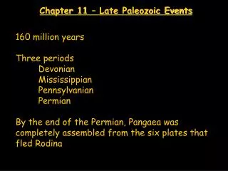
Chapter 11 Late Paleozoic Earth History
Tully Monster • Tullimonstrum gregarium, also known as the Tully Monster, is Illinois’s official state fossil • Specimen from Pennsylvanian rocks, Mazon Creek Locality, Illinois • Reconstruction of the Tully Monster • about 30 cm long
Mazon Creek Fossils • Approximately 300 million years ago • in the region of present-day Illinois, • sluggish rivers flowed southwestward through swamps, • and built large deltas that extended outward into a subtropical shallow sea • These rivers deposited high quantities of mud • that entombed many of the plants and animals living in the area • Rapid burial • and the formation of ironstone concretions • preserved many of the plants and animals of the area
Exceptional Preservation • The resulting fossils, • known as the Mazon Creek fossils • for the area in northeastern Illinois • where most specimens are found, • provide us with significant insights about the soft-part anatomy of the region's biota • Because of the exceptional preservation of this ancient biota, • Mazon Creek fossils are known throughout the world • and many museums have extensive collections from the area
Pennsylvanian Delta Organisms • During Pennsylvanian time, two major habitats existed in northeastern Illinois • One was a swampy forested lowland of the subaerial delta, • and the other was the shallow marine environment of the actively prograding delta • Living in the warm, shallow waters • of the delta front were numerous • cnidarians, • mollusks, • echinoderms, • arthropods, • worms, • and fish
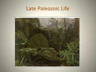
Swampy Lowlands • The swampy lowlands surrounding the delta were home to more than 400 plant species, • numerous insects and spiders, • and other animals such as • scorpions and amphibians • In the ponds, lakes, and rivers were many • fish, shrimp, and ostracods • Almost all of the plants were • seedless vascular plants, • typical of the kinds that lived in the coal-forming swamps • during the Pennsylvanian Period
Tully Monster • One of the more interesting Mazon Creek fossils is the Tully Monster, • which is not only unique to Illinois, • but also is its official state fossil • Named for Francis Tully, • who first discovered it in 1958, • Tullimonstrum gregarium • was a small • up to 30 cm long • soft-bodied animal that lived in the warm, shallow seas • covering Illinois about 300 million years ago
Tully Monster • The Tully Monster had a relatively long proboscis • that contained a "claw" with small teeth in it • The round-to-oval shaped body was segmented • and contained a cross-bar, • whose ends were swollen, • and are interpreted by some to be the animals sense organs • The tail had two horizontal fins • It probably swam like an eel • with most of the undulatory movement occurring behind the two sense organs
Tully Monster • There presently is no consensus • as to what phylum the Tully Monster belongs • or to what animals it might be related
Late Paleozoic Paleogeography • The Late Paleozoic was a time of • evolutionary innovations, • continental collisions, • mountain building, • fluctuating seas levels, • and varied climates • Coals, evaporites, and tillites • testify to the variety of climatic conditions • experienced by the different continents during the Late Paleozoic
Gondwana Continental Glaciers • Major glacial-interglacial intervals • occurred throughout much of Gondwana • as it continued moving over the South Pole • during the Late Mississippian to Early Permian • The growth and retreat of continental glaciers • during this time • profoundly affected the world's biota • as well as contributing to global sea level changes
Continental Collisions • Collisions between continents • not only led to the formation of the supercontinent Pangaea • by the end of the Permian, • but resulted in mountain building • that strongly influenced oceanic and atmospheric circulation patterns • By the end of the Paleozoic, • widespread arid and semiarid conditions prevailed over much of Pangaea
The Devonian Period • During the Silurian, • Laurentia and Baltica collided along a convergent plate boundary • to form the larger continent of Laurasia • This collision, • which closed the northern Iapetus Ocean, • is marked by the Caledonian orogeny • During the Devonian, • as the southern Iapetus Ocean narrowed • between Laurasia and Gondwana, • mountain building continued along the eastern margin of Laurasia • with the Acadian orogeny
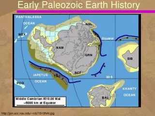
Paleogeography of the World • For the Late Devonian Period
Paleogeography of the World • For the Early Carboniferous Period
Paleogeography of the World • For the Late Carboniferous Period
Paleogeography of the World • For the Late Permian Period
Reddish Fluvial Sediments • The erosion of the resulting highlands • provided vast amounts of reddish fluvial sediments • that covered large areas of northern Europe • Old Red Sandstone • and eastern North America • the Catskill Delta
Collision of Laurentia and Baltica • Other Devonian tectonic events include, • the Cordilleran Antler orogeny, • the Ellesmere orogeny along the northern margin of Laurentia • which may reflect the collision of Laurentia with Siberia • and the change from a passive continental margin to an active convergent plate boundary • in the Uralian mobile belt of eastern Baltica
Uniform Global Climate • The distribution of • reefs, • evaporites, • and red beds, • as well as the existence of similar floras throughout the world, • suggests a rather uniform global climate during the Devonian Period
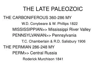
The Carboniferous Period • During the Carboniferous Period • southern Gondwana moved over the South Pole, • resulting in extensive continental glaciation • The advance and retreat of these glaciers • produced global changes in sea level • that affected sedimentation pattern on the cratons • As Gondwana continued moving northward, • it first collided with Laurasia • during the Early Carboniferous • and continued suturing with it during the rest of the Carboniferous
Gondwana/Laurasia Collision • Because Gondwana rotated clockwise relative to Laurasia, • deformation of the two continents generally progressed in a northeast-to-southwest direction along • the Hercynian, • Appalachian, • and Ouachita mobile belts • The final phase of collision between Gondwana and Laurasia • is indicated by the Ouachita Mountains of Oklahoma • which were formed by thrusting • during the Late Carboniferous and Early Permian
Pangaea Began Taking Shape • Elsewhere, Siberia collided with Kazakhstania • and moved toward the Uralian margin of Laurasia (Baltica), • colliding with it during the Early Permian • By the end of the Carboniferous, • the various continental landmasses were fairly close together • as Pangaea began taking shape
Coal Basins in Equatorial Zone • The Carboniferous coal basins of • eastern North America, • western Europe, • and the Donets Basin of Ukraine • all lay in the equatorial zone, • where rainfall was high and temperatures were consistently warm • The absence of strong seasonal growth rings • in fossil plants from these coal basins • is indicative of such a climate
Fossil Plants of Siberia • The fossil plants found in the coals of Siberia, • however, show well-developed growth rings, • signifying seasonal growth • with abundant rainfall • and distinct seasons • such as occur in the temperate zones • at latitudes 40 degrees to 60 degrees north
Continental Ice Sheets • Glacial condition • and the movement of large continental ice sheets • in the high southern latitudes • are indicated by widespread tillites • and glacial striations in southern Gondwana • These ice sheets spread toward the equator and, • at their maximum growth, • extended well into the middle temperate latitudes
The Permian Period • The assembly of Pangaea • was essentially completed during the Permian • as a result of the many continental collisions • that began during the Carboniferous • Although geologists generally agree • on the configuration and locations • of the western half of the supercontinent, • no consensus exists • on the number or configuration of the various terranes • and continental blocks that composed the eastern half of Pangaea
Pangaea Surrounded • Regardless of the exact configuration • of the eastern portion of Pangaea, • geologists know that the supercontinent • was surrounded by various subduction zones • and moved steadily northward during the Permian • Furthermore, an enormous single ocean, • Panthalassa, • surrounded Pangaea and • spanned Earth from pole to pole
Climatic Consequences • The formation of a single large landmass • had climatic consequences for the continent • Terrestrial Permian sediments indicate • that arid and semiarid conditions were widespread over Pangaea • The mountain ranges produced by • the Hercynian, Alleghenian, and Ouachita orogenies • were high enough to create rain shadows • that blocked the moist, subtropical, easterly winds • much as the southern Andes Mountains do in western South America today
Mountains Influenced Climate • The mountains’ influence produced very dry conditions in North America and Europe, • as evident from the extensive • Permian red beds and evaporites • found in western North America, central Europe, and parts of Russia • Permian coals, • indicative of abundant rainfall, • were mostly limited to the northern temperate belts • latitude 40 degrees to 60 degrees north • while the last remnants of the Carboniferous ice sheets retreated
Late Paleozoic History of North America • The Late Paleozoic cratonic history of North America included periods • of extensive shallow-marine carbonate deposition • and large coal-forming swamps • as well as dry, evaporite-forming terrestrial conditions • Cratonic events largely resulted from changes in sea level because of • Gondwanan glaciation • and tectonic events related to the joining of Pangaea
Mountain Building • Mountain building • that began with the Ordovician Taconic orogeny • continued with the • Caledonian, • Acadian, • Alleghenian, • and Ouachita orogenies • These orogenies were part of the global tectonic process • that resulted in the formation of Pangaea by the end of the Paleozoic Era
The Kaskaskia Sequence • The boundary between • the Tippecanoe sequence • and the overlying Kaskaskia sequence • Middle Devonian-Late Mississippian • is marked by a major unconformity • As the Kaskaskia Sea transgressed • over the low-relief landscape of the craton, • the majority of the basal beds deposited • consisted of clean, well-sorted quartz sandstones
Oriskany Sandstone • A good example is the Oriskany Sandstone • of New York and Pennsylvania • and its lateral equivalents • The Oriskany Sandstone, • like the basal Tippecanoe St. Peter Sandstone, • is an important glass sand • as well as a good gas-reservoir rock
Basal Kaskaskia Sandstones • Extent of the basal units of the Kaskaskia sequence in the eastern and north-central United States
Source Areas • The source areas for the basal Kaskaskia sandstones • were primarily the eroding highlands of the Appalachian mobile belt area, • exhumed Cambrian and Ordovician sandstones cropping out along the flanks of the Ozark Dome, • and exposures of the Canadian Shield in the Wisconsin area
Devonian Period • Paleogeography of North America during the Devonian Period
Sediment Sources • The earlier Silurian carbonate beds • below the Tippecanoe-Kaskaskia unconformity • lacked Kaskaskia-like sands • The absence of such sands indicates • that the source areas for the basal Kaskaskia • had still been submerged and not yet exposed at the time the Tippecanoe sequence was deposited • Stratigraphic studies indicate • that these source areas were uplifted • and the Tippecanoe carbonates removed by erosion • prior to the Kaskaskia transgression
Kaskaskian Rocks • Kaskaskian basal rocks • elsewhere on the craton • consist of carbonates • that are frequently difficult to differentiate • from the underlying Tippecanoe carbonates • unless they are fossiliferous • The majority of Kaskaskian rocks are • carbonates, including reefs, and associated evaporite deposits • except for widespread Upper Devonian and Lower Mississippian black shales
Other Parts of the World • In many other parts of the world, such as • southern England, • Belgium, • Central Europe, • Australia, • and Russia, • the Middle and early Late Devonian epochs were times of major reef building
Reef Development in Western Canada • The Middle and Late Devonian-age reefs of western Canada • contain large reserves of petroleum • and have been widely studied from outcrops and in the subsurface • These reefs began forming • as the Kaskaskia Sea transgressed southward • into western Canada
Middle Devonian Reefs and Evaporites • By the end of the Middle Devonian, • the reefs had coalesced into a large barrier-reef system • that restricted the flow of oceanic water into the back-reef platform, • thus creating conditions for evaporite precipitation • In the back-reef area, up to 300 m of evaporites • were precipitated in much the same way as in the Michigan Basin during the Silurian
Devonian Reef Complex • Reconstruction of the extensive Devonian Reef complex of western Canada • These reefs controlled the regional facies of the Devonian epeiric seas
Potash from Evaporites • More than half of the world's potash, • which is used in fertilizers, • comes from these Devonian evaporites • By the middle of the Late Devonian, • reef growth stopped in the western Canada region, • although nonreef carbonate deposition continued
Black Shales • In North America, many areas of carbonate-evaporite deposition • gave way to a greater proportion of shales • and coarser detrital rocks • beginning in the Middle Devonian and continuing into the Late Devonian • This change to detrital deposition • resulted from the formation of new source areas • brought on by the mountain-building activity • associated with the Acadian orogeny in North America
Increased Detrital Deposition • Deposition of black shales • was brought on by the the Acadian orogeny
Widespread Black Shales • As the Devonian Period ended, • a conspicuous change in sedimentation took place over the North American craton • with the appearance of widespread black shales • These Upper Devonian-Lower Mississippian black shales are typically • noncalcareous, • thinly bedded, • and usually less than 10 m thick
Extent of Black Shales • The extent of the upper Devonian and Lower Mississippian Chattanooga Shale and its equivalent units • such as the Antrim Shale and the Albany Shale
New Albany Shale • Upper Devonian New Albany Shale, • Button Mold Knob Quarry, Kentucky
Dating Black Shales • Because most black shales lack body fossils, • they are difficult to date and correlate • However, microfossils, such as • conodonts • microscopic animals • acritarchs • microscopic algae • or plant spores • indicate that the lower beds are Late Devonian, • and the upper beds are Early Mississippian in age