Download
1 / 15
150 likes | 437 Views
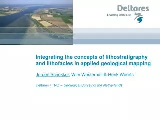
Integrating the concepts of lithostratigraphy and lithofacies in applied geological mapping . Jeroen Schokker , Wim Westerhoff & Henk Weerts Deltares / TNO – Geological Survey of the Netherlands. Aim.

E N D
Integrating the concepts of lithostratigraphy and lithofacies in applied geological mapping Jeroen Schokker, Wim Westerhoff & Henk Weerts Deltares / TNO – Geological Survey of the Netherlands
Aim • To show that a combination of lithostratigraphic classification and lithofacies modelling allows for the construction of subsurface models that are best capable to address applied geological questions • Context: • Based on the interpretation of core material, not outcrops • Regional to nation-wide modelling scale • Presence of a well-structured core description database • Presence of elaborate computer modelling skills • Addressing geohydrological, geotechnical and geochemical problems requests spatial information on layer properties that are intimately linked to sedimentary architecture and lithology Schokker, Westerhoff & Weerts
Lithostratigrapic concept • Criteria for stratigraphic subdivision: • Based on lithological characteristics that are macroscopically visible in core material • Units have an unequivocal stratigraphic position and distinct boundaries • Units are mappable on a 1/50,000 scale • System characteristics: • Hierarchical structure with the formation as central unit (cf. Salvador (ed.), 1994) • Applicable on large sets of standardised core decriptions • Basis for parameterisation of layer properties Schokker, Westerhoff & Weerts
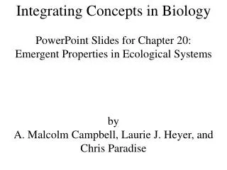
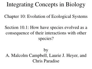
Lithostratigraphy and scale (after: Heinz & Aigner, 2003) Schokker, Westerhoff & Weerts
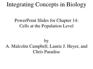
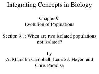
Lithostratigraphic modelling Schokker, Westerhoff & Weerts
But what about the application? • The concept and scale of a lithostratigraphic unit do not allow for a sensible schematisation in applied geological modelling • Sediment properties are highly variable on small spatial scales • Fluvial sand ≠ fluvial sand (channel, levee, crevasse, etc.) • Interpolation does not resolve this problem • The lithofacies concept and sensible spatial modelling might help… Schokker, Westerhoff & Weerts
Model complexity Nation-wide to regional model: geological units at the formation / member / bed level Top-layer model: based on facies distribution within stratigraphic units; used in numerical parameterisation Schokker, Westerhoff & Weerts
Lithofacies concept • Sediment properties are directly derived from the sedimentary environment the deposits originated in. This includes lithology and sedimentary architecture • Unit scale depends on the model application, but is typically m-scale • Units are lithofacies associations rather than individual lithofacies (cf. Miall. 1999) • Sedimentary environments repeat itself in geological time. Therefore, only 27 lithofacies units are needed to characterise all Quaternary deposits in the subsurface of the Netherlands Schokker, Westerhoff & Weerts
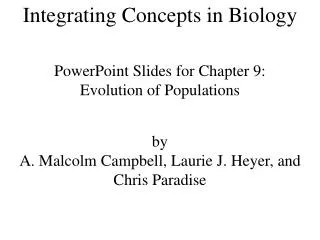
Example: estuarine environment • Lithofacies units: • Marine lithofacies units • Coastal lithofacies units • “Tidal channel” • “Tidal flat” • “Salt marsh” • “Coastal lagoon” • Fluvial lithofacies units (after: Allen, 1991) Schokker, Westerhoff & Weerts
Lithostratigraphy, lithofacies and scale (after: Heinz & Aigner, 2003) Schokker, Westerhoff & Weerts
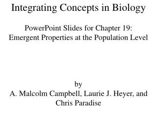
Lithofacies modelling Schokker, Westerhoff & Weerts
Tidal flat deposits Tidal channel deposits (sand) Tidal channel deposits (shells) Example: Province of Zeeland N Schokker, Westerhoff & Weerts
Conclusions • Lithostratigraphic classification is a first step in organising the apparent chaos in the subsurface up to the level of architectural elements. Beyond that level, further lithostratigraphic subdivision is not very useful • A combination of lithostratigraphic classification and lithofacies modelling enables the construction of subsurface models that are best capable to address applied geological questions Schokker, Westerhoff & Weerts
More information • Lithostratigraphy and 2D lithostratigraphic modelling: • www.dinoloket.nl • 3D lithofacies modelling: • Session IEI-22–25. August 9, 15:00 (room A1-1) • “3D subsurface characterization of the Netherlands: Results from stochastic modelling”by Jan Stafleu • Thank you for your attention • jeroen.schokker@tno.nl Schokker, Westerhoff & Weerts
Integrating the concepts of lithostratigraphy and lithofacies in applied geological mapping Jeroen Schokker, Wim Westerhoff & Henk Weerts Deltares / TNO – Geological Survey of the Netherlands