Download
1 / 28
280 likes | 412 Views
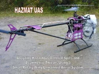
HAZMAT UAS. Anayzing Hazardous Material Spills and Asymmetric Threats Using a Small Rotary-Wing Unmanned Aerial System. Hazmat Heli Demo Pictures. HAZMAT UAS Scenarios. Explosion Urban environment, casualties, line of sight obscuration, radiation Search and Rescue

E N D
HAZMAT UAS Anayzing Hazardous Material Spills and Asymmetric Threats Using a Small Rotary-Wing Unmanned Aerial System
HAZMAT UAS Scenarios • Explosion • Urban environment, casualties, line of sight obscuration, radiation • Search and Rescue • Person missing in area with limited tree cover • HAZMAT Release • Tanker truck/train incident, find and read hazmat sign • Water Rescue • Tour boat incident, locate personnel • Large Fire • Provide imagery of area to aid commander • Chemical/Biological Release • Intentional release of toxic agents, confirm location and distribution
Measures of Performance • Time from arrival on site to launch • Time from launch to arrival on-scene • Total time on-scene • Total flight time • Real-time imagery (video, HD, frame rate) • Quality of imagery (NIIRS, PSF) • Ability to provide both EO and IR imagery (NIIRS) • Ability to carry additional sensors • (rad/bio/chem/acoustic)
Measures of Effectiveness • Quality of information allows scene commander to make decisions: • NIIRS rating of imagery (measure PSF under flight conditions) • Time taken to produce results • Ability for persistent surveillance • Time to detect/classify/localize person in SAR scenario • Ability to carry a dosimeter and effectively map a radiation field • Time to find and effectively read HAZMAT signs on vehicles • Ability to map affected areas: • Accuracy of map • Time to produce map • IR imagery for mapping fires and SAR • Determine presence of chem/bio materials • Payload capability
UAS Avenues of Study • CONOPS • Human Factors • Payloads • Latency • Cost • Platforms $ M $100s k $25 k $60 k $ 100
High Resolution Low Resolution CONOPS
150m 100m Video vs Digital
Resolution Elements Modulation Transfer Function • Point Spread Func. • Rayleigh limit • Pixels/TTP element • Required resolution Detect 4 pixels Identification 50 pixels 17% Contrast 9% Contrast
Camera Characteristics • Modulation Transfer Function (MTF): • ~MTF30 = 0.43 • Field of View ~47 degrees • 4280x2848 total pixels • JPEG format • This gives ~900 pixels on a face • target at 300m slant range • Contrast depends on background, • temperature etc.
1-cm wide strips At 50 m
Image Processing Techniques • Automatic target detection, tracking, classification and identification • Richardson-Lucy de-convolution • Super resolution • Image mosaicing • Stabilization • Change detection • Geo-location • 3D Visualization
Video and Digital Imaging
Image Resolution Studies Image of Dangerous Goods Sign at 40 metres
Super Resolution, Mosaicing Real-time video mosaicing Super resolution algorithms
Video and Digital Imagery Slant Range 300m
Video Stabilization • Real time video stabilization
Mosaic • Real time video • Geo referenced
Slant Range Effects on Identification 20 m 30 m 40 m 10 m 70 m 50 m 60 m
Image Performance Limits for a Small UAS 70 m Lucky Image Original 60 m
Future Performance HAZMAT UAS • Target identification criteria • met at 300m slant range • Sufficient resolution for • HNeT automatic facial • recognition Typical images At 300m Video
HAZMAT Test Area SAR Area Chem/Bio Release UAS Base Test Area Test Targets Explosion 100 metres Hazmat Accident