Latitude and Longitude Map Notes
This text explores the fundamental differences between maps and globes, highlighting the importance of understanding Earth's shape as an oblate spheroid. Maps, while providing detailed information about locations and features, can introduce distortions in size and shape. The concepts of latitude and longitude are essential for precise navigation, with latitude lines running parallel to the equator and longitude lines converging at the poles. An understanding of these concepts is vital for professions such as surveying and military operations, which rely on accurate geographic positioning.

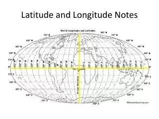
Latitude and Longitude Map Notes
E N D
Presentation Transcript
Map vs. Globe • GLOBE- three dimensional model of the Earth • It correctly shows the shapes and sizes of features on Earth. • Earth is NOT a perfect sphere! • Slightly flattened at the poles and bulging at the Equator • Actual Shape: Oblate Spheroid
Map vs. Globe • MAP-a flat model, or drawing of the Earth’s surface. • Maps show more detail about various things such as locations, distances, streets, buildings, weather, and even soil type.
Map Distortions • Taking a round object and making it flat causes errors or DISTORTIONS. • Distortions can occur in size, shape, or distances. • Mercator Projections-Cause more distortions the farther away from the equator/closer to the poles.
Latitude & Longitude • Using latitude and longitude coordinates gives more precise locations. • Who uses latitude and longitude? Examples: surveyors and military • Latitude and Longitude are measured in units known as degrees. • One degree of Latitude is approximately 70 miles on Earth’s surface. • One degree of Latitude is 60 minutes. • One minute of Latitude is 1.16 miles.
Latitude • The distance in degrees, NORTH or SOUTH of the Equator. • Equator is 0⁰ and divides the Earth into hemispheres. • Imaginary latitude lines run from the East to West. • Aka- “Parallels” • Highest latitude- 90⁰N • Lowest latitude- 90⁰S
Longitude • The distance in degrees EAST or WEST of the Prime Meridian. • Prime Meridian is 0⁰ and runs through Greenwich, England. • Lines run from North to South and curve! • Aka- “Meridians” • Highest longitude is 180⁰ • The opposite side of Prime Meridian is the International Date Line or aka the 180th meridian.