Download
1 / 6
90 likes | 515 Views
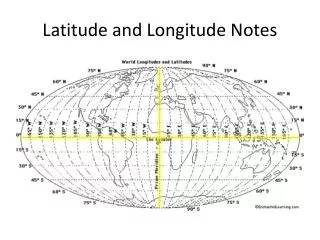
Latitude and Longitude Notes. TONAWANDA Sunk Oct. 18 1870. Latitude N 042 o 050' Longitude W 078 o 058'. Latitude and Longitude. • Are imaginary lines on a map. • They help you to pin point an exact location on a map. Latitude.

E N D
TONAWANDA Sunk Oct. 18 1870 Latitude N 042o 050' Longitude W 078o 058'
Latitude and Longitude • Are imaginary lines on a map • They help you to pin point an exact location on a map
Latitude Tells you how far NORTH or SOUTH of the equator you are. 0 (zero) degrees latitude is called the EQUATOR.
Longitude Tells you how far EAST or WEST of the prime meridian you are. 0 (zero) degrees longitude is called the PRIME MERIDIAN.
42° 43’48”N by 78° 49’43”W When you are given the location this way LATITUDE is always listed FIRST and LONGITUDE is listed SECOND.