Download

1 / 10
100 likes | 268 Views
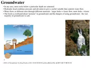
RECAP GROUNDWATER. Groundwater. Current Use: DOTD Well Survey (1 mi radius/12 mo) 500 foot walking receptor survey Potential Use: sustainable yield total dissolved solids. Groundwater Classifications. Groundwater Classification 1 : public water supply

E N D
RECAP GROUNDWATER
Groundwater • Current Use: • DOTD Well Survey (1 mi radius/12 mo) • 500 foot walking receptor survey • Potential Use: • sustainable yield • total dissolved solids
Groundwater Classifications Groundwater Classification 1: public water supply • Yield > 4,800 g/d • TDS < 1,000 mg/l Class 1A: current public water supply Class 1B: potential public water supply
Groundwater Classifications Groundwater Classification 2: domestic water supply • Yield > 800 g/d but < 4,800 g/d • TDS < 10,000 mg/l Class 2A: current domestic water supply Class 2B: potential domestic water supply (TDS < 1,000) Class 2C: potential domestic water supply (TDS >1000 but < 10,000)
Groundwater Classifications Groundwater Classification 3: Not a potential public or domestic water supply Class 3A: yield < 800g/d Class 3B: TDS > 10,000 mg/l
Groundwater: POC and POE Point of Compliance • point where RECAP standard must be met Point of Exposure • point of actual or potential contact between a receptor and a COC
Groundwater 1: POC and POE • Point of Exposure: • throughout the aquifer to be protected or restored • Point of Compliance: • sampling location placed as near to the source as feasible without causing an adverse impact
Groundwater2: POC and POE Point of Exposure: • on-site exposure point, or • property boundary, or • nearest downgradient point off-site Point of Compliance: • sampling location placed as near to the source as feasible without causing an adverse impact
Groundwater 3: POC and POE Point of Exposure: • point of discharge to a surface water body within the aquifer Point of Compliance: • sampling location placed as near to the source as feasible without causing an adverse impact
Point of Compliance (POC) and Point of Exposure (POE) GW-1 Site Boundaries POC POE THROUGOUT AQUIFER Flow Direction GW-2 Road POC POC POE POE Flow Direction GW-3 POC POE Water Body Flow Direction