Download
1 / 117
1.17k likes | 1.42k Views
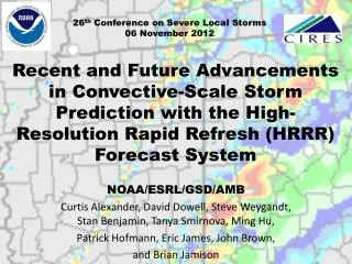
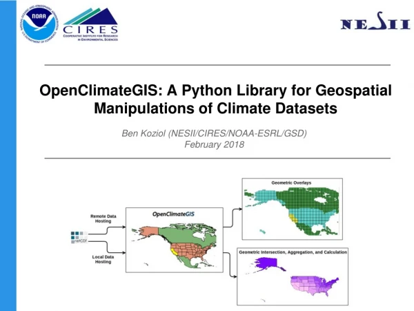
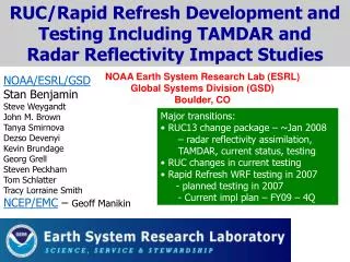
RUC/Rapid Refresh Development and Testing Including TAMDAR and Radar Reflectivity Impact Studies. NOAA Earth System Research Lab (ESRL) Global Systems Division (GSD) Boulder, CO. NOAA/ESRL/GSD Stan Benjamin Steve Weygandt John M. Brown Tanya Smirnova Dezso Devenyi Kevin Brundage

E N D
RUC/Rapid Refresh Development and Testing Including TAMDAR and Radar Reflectivity Impact Studies NOAA Earth System Research Lab (ESRL) Global Systems Division (GSD)Boulder, CO NOAA/ESRL/GSD Stan Benjamin Steve Weygandt John M. Brown Tanya Smirnova Dezso Devenyi Kevin Brundage Georg Grell Steven Peckham Tom Schlatter Tracy Lorraine Smith NCEP/EMC – Geoff Manikin • Major transitions: • RUC13 change package – ~Jan 2008 • – radar reflectivity assimilation, TAMDAR, current status, testing • RUC changes in current testing • Rapid Refresh WRF testing in 2007 • - planned testing in 2007 • - Current impl plan – FY09 – 4Q
RUC 3dvar 3dvar Obs Obs RUC Hourly Assimilation Cycle Cycle hydrometeor, soil temp/moisture/snow plus atmosphere state variables Hourly obs in 2008 RUC Data Type ~Number Rawinsonde (12h) 80 NOAA profilers 30 VAD winds 110-130 PBL – prof/RASS ~25 Aircraft (V,temp) 1400-4500 TAMDAR (V,T,RH) 0-1000 Surface/METAR 1500-1700 Buoy/ship 100-150 GOES cloud winds 1000-2500 GOES cloud-top pres 10 km res GPS precip water ~300 Mesonet (temp, dpt) ~7000 Mesonet (wind) ~ 600 METAR-cloud-vis-wx ~1500 Radar / lightning 2km 1-hr fcst 1-hr fcst 1-hr fcst Background Fields Analysis Fields Time (UTC) 11 12 13
RUC • Rapid • Refresh • (2009) • Hourly NWP • Update for: • CONUS • AK/Can • Pac/Atl • Caribbean Planned approx Rapid Refresh domain Current RUC CONUS domain • NWP updated hourly w/ latest obs • Aviation / transportation • Severe weather • Decision support tools
RUC History – NCEP (NMC) implementations • - First operational implementation of RUC • - 60km resolution, 3-h cycle • 1998 – 40km resolution, 1-h cycle, • - cloud physics, land-sfc model • 2002 – 20km resolution • - addition of GOES cloud data in assimilation • 2005 – 13km resolution, new obs (METAR clouds, GPS moisture), new model physics • 2008 (Jan) – Assimilation of radar reflectivity, improved thunderstorm forecasting • 2009 – WRF-based Rapid Refresh to replace RUC NOAA/GSD testing – precedes NCEP ops by 0.5-3 years
Jan 2008 Changes for oper RUC upgrade • Assimilation • Use of radar reflectivity in RUC diabatic digital filter initialization in RUC model • Mesonet winds using mesonet provider uselist • TAMDAR aircraft observations • (TAMDAR impact para RUC tests at GSD) • Model physics • RRTM longwave radiation • Mod to Grell-Devenyi – decrease areal coverage • Mod to RUC land-sfc model – fresh snow density • Post-processing – add reflectivity fields
RUC change package – Jan2008 - continued • Model changes • RRTM longwave radiation, replacing Dudhia LW (largely eliminates warm bias in RUC) • Mod to Grell-Devenyi convective scheme • (reduce excessive areal coverage for light precip) • Mod to snow component of RUC land-sfc model for snow density • (decrease excessively cold 2m air temps over fresh snow cover at night)
RRTM Longwave Radiation in RUC Upgrade • Effect on 2-m temperature forecasts • Much decreased warm bias, esp. at nighttime 2-m temp bias (obs – forecast) 1-month comparison 14 May –13 June 07 Eastern US only 12h RUC oper – Dudhia LW 3h 12h RUC para – RRTM LW COLD WARM 3h 0 3 6 9 12 15 18 21 UTC
9h fcst - Oper RUC 9h fcst – para RUC Better 2m temp forecast From para RUC w/ RRTM LW Anx valid 09z
9h fcst - Oper RUC 9h fcst – para RUC Today Better 2m temp forecast From para RUC w/ RRTM LW Anx valid 09z
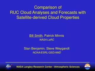
RUC cloud analysis since 2005 – Use of cloud / hydrometeor observations to modify cycled cloud / hydrometeor fields Background Cloud water + cloud ice Cloud assessment (YES/NO/UNKNOWN) from observations (METAR/sat/radar)
RUC change package – 2007 – one more thing • Assimilate mesonet winds from accepted provider uselist • Allows about 600 additional wind observations to be used hourly in RUC • Primary mesonet providers (e.g., Citizens Weather, AWS) have common siting problems • Mesonet winds turned off for RUC13 implementation in 2005 • New RUC treats each mesonet provider separately • Station-by-station reject list will allow use of many Citizens-Wx, AWS stations in future Poster – Mesonet QC monitoring web site – Benj et al http://ams.confex.com/ams/pdfpapers/124829.pdf
The Thunderstorm Prediction Problem for Aviation and Severe Weather • Most significant weather problem for aviation operations. • Requirement for improved hourly-updated 2-8h forecast for air traffic management. • Current situation • Large uncertainty even for short lead time • Very small-scale, deterministic forecasts difficult • Severe convective weather -- significant impact on human activities
The Thunderstorm Prediction Problem • Two separate, but related problems: • Convective initiation • Convective evolution (including decay)
The Thunderstorm Prediction Problem • Two separate, but related problems: • Convective Initiation • Convective evolution Need very accurate forecast of mesoscale environment
The Thunderstorm Prediction Problem • Two separate, but related problems: • Convective Initiation • Convective evolution • Excellent near-surface physics • High frequency assimilation of asynoptic observations (surface METAR and mesonet, wind profilers, aircraft) Need very accurate forecast of mesoscale environment
The Thunderstorm Prediction Problem • Two separate, but related problems: • Convective Initiation • Convective evolution • Excellent near-surface physics • High frequency assimilation of asynoptic observations (surface METAR and mesonet, wind profilers, aircraft) Need very accurate forecast of mesoscale environment Nighttime convection often elevated – even harder
Once convection is ongoing… • WSR-88D provides invaluable observations • Much improved operational warning, nowcasting • Operational NWP community slow to utilize radar reflectivity data in models • Real-time Level II (3-d) data access issues • Difficulties assimilating reflectivity
Diabatic Digital Filter Initialization (DDFI) -30 min -15 min Init +15 min Backwards integration, no physics Forward integration, full physics Obtain initial fields with improved balance RUC model forecast
Diabatic Digital Filter Initialization (DDFI)add assimilation of radar data -30 min -15 min Init +15 min Backwards integration, no physics Forward integration, full physics Apply latent heating from radar reflectivity, lightning data Obtain initial fields with improved balance, vertical circulations associated with ongoing convection RUC model forecast
RUC reflectivity assimilation procedure • Force precipitation in areas with radar echoes • Specify 3D latent heat from reflectivity • Apply latent heat within forward integration of diabatic digital filter initialization (DDFI) • Replace temperature tendency from cumulus parameterization and explicit microphysics • Moisten echo region, do not add hydrometeors • Suppress convection in echo-free areas • Create convective suppression mask (> 300 mb deep layer > 100 km from existing convection • Inhibit cumulus parameterization during DDFI and 1st 30 min. of model integration
Advantages of radar assimilation procedure • Minimal shock to model • Coherent wind, temperature and moisture fields evolve in response to heating within DDFI • Very little additional computer cost • DDFI already used to control noise • Independent of model or physics packages • Can be applied to Rapid Refresh WRF, other models
RUC radar assimilation test case NSSL radar reflectivity mosaic Test case 00z 8 Jan 2007 Experiment (EXP) • LH temperature tendency in DDFI (no moistening, no suppression yet) Control (CNTL) • Standard initialization (no radar assimilation)
NSSL 3-km radar reflectivity (dbz) K=15 LH temp. tend. (K / 15 min) 00z 8 Jan 2007 Contour interval = 0.5 K
Reflectivity experiments within RUC • CNTL standard initialization – no radar init • EXP LH nudging within DDFI no adding hydrometeors from reflectivity no moistening in reflectivity region
K=15 U-comp. diff (EXP - CNTL) K=35 U-comp. diff (EXP - CNTL) Contour interval = 0.2 m/s Low-level Convergence Upper-level Divergence
“Pyramids of silence” complementing “cones of radar data” Latent heating in diabatic forward DFI step specified only where 3-d radar data available NSSL mosaic Z = 5 kft 1700 UTC 27 Jan 2004 NSSL mosaic Z = 20 kft NSSL mosaic Z = 10 kft
00z 3-km refl (dBZ) EXP 45-60 min. prec. cint = 0.5 mm NSSL mosaic
CNTL 45-60 min. prec. EXP 45-60 min. prec. cint = 0.5 mm cint = 0.5 mm
CNTL 105-120 min. prec. EXP 105-120 min. prec. cint = 0.5 mm cint = 0.5 mm
CNTL 165-180 min. prec. EXP 165-180 min. prec. cint = 0.5 mm cint = 0.5 mm
02z 3-km refl (dBZ) EXP 115-120 min. prec. cint = 0.5 mm NSSL mosaic
105-120 min. accum. precipitation NSSL reflectivity CNTL EXP 02z 8 Jan 2007 Contour interval = 0.5 mm
Radar obs – 00z 25 Mar 2007 Real-time parallel testing at GSD (started February 2007) Added simulated RUC radar reflectivity field Assimilation improvement most clear in reflectivity field(smeared in precipitation field) RUC 3-h forecasts valid 00z 25 Mar 2007 No radar assimilation With radar assimilation
03z 1 Mar 2007 03z 1 Mar 2007 Analyzed 700 mb vert. vel. from RUC with and without radar assimilation 0-h vert. vel. 0-h vert. vel. Radar assim No radar assim Real-time case from 03z 1 March 2007 NSSL Reflectivity mosaic Obs. reflectivity 03z 1 Mar 2007
3-h precip. 3-h precip. 3-h fcst accum. precip. from RUC with and without radar assimilation No radar assim Radar assim 06z 1 Mar 2007 06z 1 Mar 2007 Real-time case from 03z 1 March 2007 NSSL Reflectivity mosaic Obs. reflectivity 06z 1 Mar 2007
Suppress convection Allow convection No coverage Radar reflectivity assimilation Part 2 – convection suppression • Define suppression areas as follows: • No reflectivity > 20 dbZ within 100 km • Depth of radar data > 300 hPa • Complemented by GOES fully clear areas Accomplish in RUC model: Specify minimum cap depth as 0 hPa in DFI step and first 30 min in actual forecast
Convective suppression example Suppress convection Allow convection No coverage NSSL reflectivity Suppression mask Real-time case from 12z 7 June 2007
Convective suppression example Radar Assimilation NSSL 3-h precipitation Control Real-time 3-h forecasts valid 15z 7 June 2007 Valid 15z 7 June 2007 convective suppression - How does it work? – Reduces latent heating, vert. motion in erroneous conv areas
RUC “analysis” composite refl (actually 1h fcst) 0900z NSSL Q2 composite refl 0900z Tues 17 July 2007
RUC “analysis” composite refl (actually 1h fcst) 0900z NSSL Q2 composite refl 0900z Tues 17 July 2007
RUC 3h forecast composite refl 1200z NSSL Q2 composite refl Valid 1200z Tues 17 July 2007
RUC 3h forecast with RADAR ASSIM NSSL Q2 QPE Precip – 3h –09-12z Tues 17 July 2007
RUC 3h forecast with RADAR ASSIM NSSL Q2 QPE Precip – 3h –09-12z Tues 17 July 2007
RUC 3h forecast without RADAR ASSIM NSSL Q2 QPE Precip – 3h –09-12z Tues 17 July 2007
Precip – 3h –09-12z Tues 17 July 2007 NSSL Q2 QPE RUC 3h forecasts with RADAR ASSIM without RADAR ASSIM
RUC “analysis” composite refl (actually 1h fcst) 1200z NSSL Q2 composite refl 1200z Tues 17 July 2007
RUC 3h forecast with RADAR ASSIM 1500z NSSL Q2 composite refl 1800z Tues 17 July 2007
RUC forecast unable to hold onto squall line - result of Grell-Dev limitations, not assim RUC 6h forecast with RADAR ASSIM 1800z NSSL Q2 composite refl 1500z Tues 17 July 2007
Precip – 3h –1215z Tues 17 July 2007 NSSL Q2 QPE RUC 3h forecasts 12-15z without RADAR ASSIM with RADAR ASSIM