
Watershed Location
E N D
Presentation Transcript
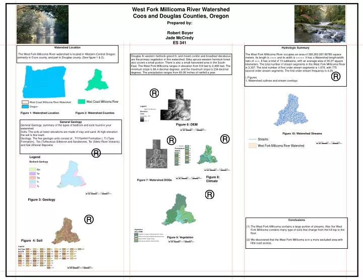
West Fork Millicoma River Watershed Coos and Douglas Counties, Oregon Prepared by: Robert Boyer Jade McCredy ES 341 • Watershed Location • The West Fork Millicoma River watershed is located in Western-Central Oregon, primarily in Coos county, and part in Douglas county. (See figure 1 & 2). • Hydrologic Summary • The West Fork Millicoma River occupies an area of 390,363,097.99785 square meters. Its length is ++++ and its width is +++++. It has a Watershed length/width ratio of +++. It has a total of 13 subbasins, with an average area of 30.07 square kilometers. The total number of stream segments in the West Fork Millicoma River is 3,337. The total number of first order stream segments is 1,679, with 775 second order stream segments. The first order stream frequency is 4.29. • i. Figures • 1. Watershed outlines and stream overlays Douglas fir-western hemlock-grand fir, and mixed conifer and broadleaf deciduous are the primary vegetation in this watershed. Sitka spruce-western hemlock forest also covers a small portion. There is also a small harvested area in the South-East. The West Fork Millicoma ranges in elevation from 9.8 feet to 2,408 feet. The minimum slope is 86.4 decimal degrees, and the maximum slope is 234 decimal degrees. The precipitation ranges from 65-90 inches of rainfall a year. Figure 1: Watershed Location Figure 2: Watershed Counties General Geology General Geology: summary of the types of bedrock and soils found in your watershed Soils: The soils at lower elevations are made of clay and sand. At high elevation the soil is fine loam. Geology: The five geologic units consist of , TY(Yamhill Formation ), Tt (Tyee Formation), Tss (Tuffaceous Siltstone and Sandstone), Tsr (Siletz River Volcanic) and Qal (Alluvial Deposits) Figure 6: DEM Figure 10: Watershed Streams Figure 8: Climate Figure 7: Watershed DOQs Figure 3: Geology Conclusions (1) The West Fork Millicoma contains a large portion of streams. Also the West Fork Millicoma contains many type of soils that change from the hill top to the floor. (2) We discovered that the West Fork Millicoma is in a more secluded area with little road access. Figure 9: Vegetation Figure 4: Soil