Download
1 / 16
160 likes | 339 Views
Upper Mississippi River Basin Association: Spills Coordination, Mapping & Planning. Joint ORSANCO -UMRBA Technical Meeting June 5, 2013. UMRBA Focus Areas. Overview. UMR Response Considerations UMR Hazardous Spills Coordination Group UMR Spill Plan and Response Manual

E N D
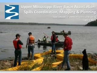
Upper Mississippi River Basin Association: Spills Coordination, Mapping & Planning Joint ORSANCO-UMRBA Technical Meeting June 5, 2013
Overview • UMR Response Considerations • UMR Hazardous Spills Coordination Group • UMR Spill Plan and Response Manual • Regional Mapping and Planning Activities (US EPA cooperative agreement) • Questions and Discussion
UMR Spill Response - Considerations • Unique Characteristics & Challenges • Complex Physical System • Locks and dams, main channel, side channel, backwaters • Flows/spill trajectories variable and hard to predict • High Value Natural Resources • Seasonal concentrations of migratory waterfowl • Threatened and endangered species • Diverse habitats, National Wildlife Refuges
UMR Spill Response - Considerations • Water Supply Used For • Drinking Water • Industrial Processes • Cooling • Presence of Commercial and Recreational Vessels • Safety considerations • Interference with response efforts • Diverse Potential Pollution Sources • Vessels, pipelines, railroads, highway crossings, industrial discharge
Need for Cooperation and Coordination in Response on the UMR • Multiple Jurisdictions and Agencies • Potential for Downstream Impacts • Government-Private Sector Coordination Important • Need to Target Limited Resources (equipment, personnel, planning, etc.)
UMR Hazardous Spills Coordination Group • Formed 1989 • Membership • Illinois • Iowa • Minnesota • Missouri • Wisconsin • USACE • USCG • USEPA • USFWS • NOAA
UMR Hazardous Spills Coordination Group • Functions • Forum for regional coordination and communication • Maintain UMR Spill Plan (Group members are signatories) • Sponsor training events • Advocate for shared positions • Meet twice per year, plus occasional training • UMRBA provides staff support
UMR Spill Response Planand Resource Manual • A contingency plan to supplement other area and agency plans (R5, R7 area) maintained by UMR Spills Group • Addresses how state and federal agencies respond to UMR spills • Includes resource manual appendices with reference information • Restricted access and public distribution versions (due to contents of appendices in resource manual) – see www.umrba.org for public plan • Currently undergoing comprehensive update.
Response Plan & Resource Manual Contents Response Plan • Public and Private Organization Roles in Response • Interstate Notification Protocol and Notification Roster • Response Protocol for UMR Spills • Incident Command System Implementation Protocol • Policy on In Situ Burning and COSTAs • Policy on Bioremediation • Policy on Vessel Detainment • State Hazardous Waste Disposal Requirements • Policy on Coordination with USACE
Response Plan & Resource Manual Contents Resource Appendices • Basic river information • county lines, locks & dams, USCG & USACE boundaries • Sensitive human and natural resources • water intakes, National Wildlife refuges, sensitive habitats • Potential sources of spills • highway and rail crossings, pipelines, dischargers, commodities transported, tributaries, oil-handling terminals • Response assets • hazmat teams, response equipment, river access points • Countermeasures • in situ burning information and considerations, chemical oil spill treating agents information and considerations
Regional Planning & Mapping Activities • Supported under cooperative agreement with USEPA Region 5 • 21 years of work, implemented under OPA 90 • Funding varies by year ($75,000 to $175,000) • 2-3 project staff, plus part of WQPD • Work focused in Illinois, Minnesota, Wisconsin • Great Lakes Commission does similar work in Indiana, Michigan, and Ohio
Regional Planning & Mapping Activities • Inland Sensitivity Atlas • State-wide atlases, completing update • Potential spill sources (pipelines, oil storage, hazardous materials, etc.) • Sensitive resources (water intakes, sensitive species, managed lands, tribal lands, marinas) • Response resources (boat accesses, response strategies) • GIS-based, GeoPDF-formatted • DVD distribution
Regional Planning & Mapping Activities • Geographic Response Planning Tools • Response Strategies for UMR Metro Areas (Sub-areas): Minneapolis-St. Paul, Quad Cities, and St. Louis • Wildlife Refuges and Other Sensitive Areas: UMR Pools 7, 10 and 13; these include initial incident action plan • Integrated into Inland Sensitivity Atlas • Habitat-Specific Response Fact Sheets • Sub-area Contingency Plan Support • Minneapolis-St. Paul, Chicago • Assist in Quad Cities, St. Louis • DEMONSTRATION
Questions and Discussion For More Information, Contact: Dave Hokanson dhokanson@umrba.org 651-224-2880 See also: UMRBA Web Site www.umrba.org