Download
1 / 32
320 likes | 410 Views
Discover how brain atlases and GIS infrastructure facilitate spatial data integration across scales, species, and projects. Explore ontology-based feature identification, spatial information infrastructure, research portals, and more. Overcome GIS challenges and delve into the SMART Atlas for brain data integration.

E N D
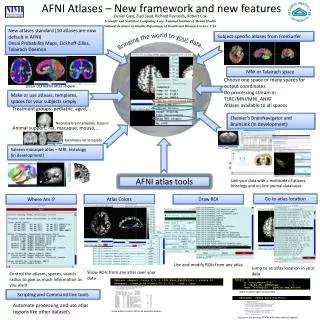
On Brain Atlases and GIS Infrastructure for spatial data integration: across scales, species and projects Ilya Zaslavsky SDSC, BIRN-CC, Mouse-BIRN
Outline • Atlas functionality • Spatial data integration • Mouse brain atlas work • Spatial information infrastructure • Uses of ontology in spatial data integration: • Ontology-based feature identification • Ontology-based location exchange • Research portals for spatial data integration • How BIRN atlas work influenced other cyberinfrastructure projects • STARE (ophthalmology) • GEON, CUAHSI, NIEHS Hurricane Response portal
What is an atlas? • a set of 2D images or a 3D volume in a specified coordinate system, with anatomic feature delineations, and a set of spatially registered annotations • What we need is more than an atlas: • A gateway to large distributed databases of images, volumes, segmentations, other spatially-registered data • Collection of spatial data sources • Collection of spatial data registries, services and workflows: • image registration, segmentation, spatial selection, spatial analysis, integration of spatial data • Collection of viewers and annotation tools with authenticated access And APIs to make them all work together
Spatial Queries on Brain Structures, including 3D queries The Smart Atlas: Spatial Integration over Distributed Data WebStart from BIRN portal
Spatial integration of distributed multiscale data The new version of the S.M.A.R.T. Brain Atlas is a MapObjects-Javabased Web applicationfor ontology-awarediscovery andintegration of distributed multiscale braindata registeredto the commonstereotaxic coordinate system.
GIS Challenges • Multiple collections of brain images/ atlases, but lack of interoperability across them • At the database and catalog levels • At the interface level • Queries such as: • “which atlas sources provide images for user-selected area of the brain at a given resolution”, or • “display image segmentations available in one atlas over a newly obtained image stored in a different location on the grid”, or • “compare protein distributions in a given area of the brain available at several atlas sources” cannot be answered without a dedicated infrastructure that supports spatial integration of brain data • Heterogeneity in: image formats – conventions – spatial registration – access, retrieval and display mechanisms The SMART Atlas is the prototype infrastructure to answer this challenge
Spatial sources and requests 1: getSources ({slice_plane_params, 2Dshape}, sp_rel) 2: getFragment(URI,plane_params,2Dshape,image_dims)
Use of Ontologies to Link Features SMART Atlas usesUnified Medical Language System (UMLS) to query across multiple data sources and explore spatial relationships across brainslices indifferent coordinate systems (eg,across species) Structures on slices color coded by relationships contained in the UMLS
Use of ontologies to delineate anatomic features 3 2 1 4 Color shows number of labels assigned to each polygon
Special Cases: 4 • ns: nigrostriatal bundle • al: ansa lenticularis, C0152352 • mfb: medial forebrain bundle, C0025055 • MCLH: magnocellular nucleus of the lateral hypothalamus • LH: lateral hypothalamic area, C0020654 • Capital letters designate nuclei (typically)ANDdotted lines typically show nuclei • Fiber tracks: small letters and solid lines • mfb and LH are siblings in UMLS; a bundle of neurons (mfb) “runs through” a nucleus (LH) the polygon is assigned “LH”, with “mfb” as a secondary (fiber bundle) designation • Same picture with “al” vs “MCLH”
MBAT Programmers Meeting From MBAT to WOMBAT Web-based Ontology-based
Architecture Clients: MBAT etc. registries Data integration tools Methods over the abstract representation – Shall have commonsignatures getExpressed(gene, feature) translate (coords) convert (formats) Gene expression 2D images 2D vector segmentations 3D volumes 4+D volumes (FMRI) Time series Phenotype/behavioral surfaces Basic data type abstraction (or physical databases) Sources
Interoperability desiderata Gensat Allen Brain Atlas CCDB, others Spatial registry MBAT Drexel’s NT UCLA’s Shiva Smart Atlas
Exchanging location information across scales and coordinate systems • Directly: • By space, using Stereotaxic coordinates • Formal coordinate system definitions • Coordinate system translation services (incl. between image and stareotaxic) • Spatial registration of images and segmentations • By anatomic feature names, via UMLS + Bonfire + Neuronames + … • Ontological registration • Semantic translation services • Indirectly • By verbal description of spatial locations relative to well-defined features (a collection of location rules) • In relative coordinates; by matching derived indices: histograms, shape indexes, etc.
Agreed-upon ROI description and state exchange protocol STATE_RETRIEVE <atlas_state> <request name="retrieve"> <sessionID>10009</sessionID> <targetatlas>shiva</targetatlas> <targetterm ontology="UMLS|..."/> <targetlocation coordsys="Stereotaxic" format="pointlist3D"/> </request></atlas_state> <atlas_state > <response name="retrieve"> <submitting_atlas>smart</submitting_atlas> <action name="highlight"> <locations> <location coordsys="Stereotaxic"> <format type="pointlist3D"> <ROI> <bbox>m1,n1,p1 m2,n2,p2</bbox> <data>x1,y1,z1 x2,y2,z2 ...</data> </ROI> </ROI> <ROI> <bbox>m1,n1,p1 m2,n2,p2</bbox> <data>x1,y1,z1 x2,y2,z2 ...</data> </ROI> </format> </location> </locations> </action> </response></atlas_state> STATE_SUBMIT <atlas_state> <request name="submit"> <sessionID>10009</sessionID> <submitting_atlas>smart</submitting_atlas> <action name="highlight|..."> <locations> <location coordsys="Stereotaxic"> <format type="pointlist3D"> <ROI> <bbox>m1,n1,p1 m2,n2,p2</bbox> <data>x1,y1,z1 x2,y2,z2 ...</data> </ROI> <ROI> <bbox>m1,n1,p1 m2,n2,p2</bbox> <data>x1,y1,z1 x2,y2,z2 ...</data> </ROI> </format> </location> </locations> </action> </request></atlas_state> <atlas_state> <response name="submit"> <status>success</status> </response></atlas_state> STATE_INIT:: <atlas_state> <request name= "initialize_session"> <user>user</user> <pwd>pwd</pwd> </request></atlas_state> <atlas_state> <response name= "initialize_session"> <sessionID>10009 </sessionID> </response></atlas_state> + Java API
Integration across clients: ROI exchange API in action SUBMITSTATE INITIALIZESERVICE RETRIEVESTATE
Accessing spatial registration sources from each viewer • Image registration workflow • Ability to plug in image registration/warping tools from LONI, Drexel, UCSD, Ohio • Spatial registry at BIRN-CC: • Oracle Spatial database; contains: • Service URI (SRB:path, or ArcIMS:URL,service,layer) • Coordinate system of the layer • Plane to which the image or markup belongs: a,b,c,d wrt stereotaxic (dorsal/ventral to bregma; anterior/posterior to bregma; lateral to midline) • Positioning of image within the plane (6 elements of TFW) • Image contour or feature extent as SDO • Signal type, and link to additional signal metadata • Additionally: • to simplify search for non-oblique slices: slice types, associated numeric constant • for visualization: thumbnail paths
Image Registration Portlet Automatic generation of spatially-registered image services
ESRI Health Sciences Brochure Presented at several GIS conferences: keynote at International Health GIS, 2004; Part of ESRI’s President’s address at GIS User Conference (2003), other…
Foveal Coordinate System Hemorrhages Cotton-Wool Fovea Optic nerve Arteries Veins Coordinate System Background The STARE (Structural Analysis of the Retina) project, UCSD
BIRN Grid architecture in other projects CI is about RE-USING data and research resources !!
Now at: http://www-apps.niehs.nih.gov/katrina/ Drinking water surface intakes and TRI facilities
Environmental justice applications: social and demographic variables overlaid with environmental effects
Data download and metadata are available for all spatial layers