Download
1 / 46
460 likes | 482 Views
Explore the structure, data sources, methodology, and criteria used for green corridors mapping. Learn about landscape types and ecological background mapping techniques.

E N D
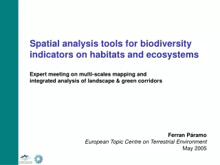
Spatial analysis tools for biodiversity indicators on habitats and ecosystems Expert meeting on multi-scales mapping and integrated analysis of landscape & green corridors Ferran Páramo European Topic Centre on Terrestrial Environment May 2005
Structure of the presentation • Data sources • Corilis Methodology • GPB: Green Potential Background • DLT: Dominant Landscape Types
K1000 E3666 N2073 2 14 71 7 6 Total surface: 100 Ha
STANDARD LAYERS CLC CORILIS Aggregation and/or Dominance DLT EBG CRITERIA DEPENDENT LAYERS
Aggregated Nomenclature CLC Level 3 Continuous urban fabric Discontinuous urban fabric Industrial or commercial units Road and rail networks and associated land Sport & leisure areas Airports 1. Artificial surfaces Mineral extraction sites Dump sites Construction sites Green urban areas Port and leisure facilities Non-irrigated arable land Permanently irrigated land 2a. Arable land & permanent crops Rice fields Vineyards Fruit trees and berry plantations Olive groves Pastures Annual crops associated with permanent crops Complex cultivation patterns Land principally occupied by agriculture, with significant areas of natural vegetation 2b. Pastures & mixed farmland Agro-forestry areas Broad-leaved forest Coniferous forest 3a. Forests and transitional woodland shrub Mixed forest Natural grasslands Moors and heathland 3b. Natural grassland, moors, heathland and sclerophylous vegetation Sclerophyllous vegetation Transitional woodland-shrub Beaches, dunes, sands Bare rocks Sparsely vegetated areas 3c. Open spaces with little or no vegetation Burnt areas Glaciers and perpetual snow Inland marshes Peat bogs 4. Wetlands Salt marshes Salines Intertidal flats Water courses Water bodies 5. Water bodies Coastal lagoons Estuaries Sea and Ocean No data
Ecological Background Smoothing radius: 5 km Grouping of 2B, 3A, 3B, 3C, 4 and 5 classes
Ecological Background Smoothing radius: 10 km Grouping of 2B, 3A, 3B, 3C, 4 and 5 classes
Ecological Background Smoothing radius: 20 km Grouping of 2B, 3A, 3B, 3C, 4 and 5 classes
Ecological Background Smoothing radius: 5 km Grouping of 2B, 3A, 3B, 3C, 4 and 5 classes Legend 0 - 80 % 80 - 100 %
Ecological Background Smoothing radius: 10 km Grouping of 2B, 3A, 3B, 3C, 4 and 5 classes Legend 0 - 80 % 80 - 100 %
Ecological Background Smoothing radius: 20 km Grouping of 2B, 3A, 3B, 3C, 4 and 5 classes Legend 0 - 80 % 80 - 100 %
Aggregated Nomenclature CLC Level 3 Continuous urban fabric Discontinuous urban fabric Industrial or commercial units Road and rail networks and associated land Sport & leisure areas Airports 1. Artificial surfaces Mineral extraction sites Dump sites Construction sites Green urban areas Port and leisure facilities Non-irrigated arable land Permanently irrigated land 2. Arable land & permanent crops Rice fields Vineyards Fruit trees and berry plantations Olive groves Pastures Annual crops associated with permanent crops Complex cultivation patterns Land principally occupied by agriculture, with significant areas of natural vegetation 3. Pastures & mixed farmland Agro-forestry areas Broad-leaved forest Coniferous forest 4. Forests and transitional woodland shrub Mixed forest Natural grasslands Moors and heathland Sclerophyllous vegetation Transitional woodland-shrub Beaches, dunes, sands Bare rocks Sparsely vegetated areas Burnt areas 5. Shrubs & other semi-natural land Glaciers and perpetual snow Inland marshes Peat bogs Salt marshes Salines Intertidal flats Water courses Water bodies Coastal lagoons Estuaries Sea and Ocean No data
a) Threshold value = mean + sdev b) Codominance criteria
Dominant Land Cover Types Smoothing radius: 5 km A1 - ARTIFICIAL DOMINANCE A2 - DISPERSED URBAN AREAS B1 - BROAD PATTERN INTENSIVE AGRICULTURE B2 - RURAL MOSAIC AND PASTURE LANDSCAPE C1 - FORESTED LANDSCAPE C2 - OPEN SEMI-NATURAL OR NATURAL LANDSCAPE D1 - COMPOSITE LANDSCAPE
A1 - ARTIFICIAL DOMINANCE A2 - DISPERSED URBAN AREAS B1 - BROAD PATTERN INTENSIVE AGRICULTURE B2 - RURAL MOSAIC AND PASTURE LANDSCAPE C1 - FORESTED LANDSCAPE C2 - OPEN SEMI-NATURAL OR NATURAL LANDSCAPE D1 - COMPOSITE LANDSCAPE Dominant Land Cover Types Smoothing radius: 10 km
Dominant Land Cover Types Smoothing radius: 20 km A1 - ARTIFICIAL DOMINANCE A2 - DISPERSED URBAN AREAS B1 - BROAD PATTERN INTENSIVE AGRICULTURE B2 - RURAL MOSAIC AND PASTURE LANDSCAPE C1 - FORESTED LANDSCAPE C2 - OPEN SEMI-NATURAL OR NATURAL LANDSCAPE D1 - COMPOSITE LANDSCAPE
Dominant Land Cover Types Legend A1 - ARTIFICIAL DOMINANCE Smoothing radius: 5 km A2 - DISPERSED URBAN AREAS B1 - BROAD PATTERN INTENSIVE AGRICULTURE B2 - RURAL MOSAIC AND PASTURE LANDSCAPE C1 - FORESTED LANDSCAPE C2 - OPEN SEMI-NATURAL OR NATURAL LANDSCAPE D1 - COMPOSITE LANDSCAPE
Dominant Land Cover Types Legend A1 - ARTIFICIAL DOMINANCE Smoothing radius: 10 km A2 - DISPERSED URBAN AREAS B1 - BROAD PATTERN INTENSIVE AGRICULTURE B2 - RURAL MOSAIC AND PASTURE LANDSCAPE C1 - FORESTED LANDSCAPE C2 - OPEN SEMI-NATURAL OR NATURAL LANDSCAPE D1 - COMPOSITE LANDSCAPE
Dominant Land Cover Types Legend A1 - ARTIFICIAL DOMINANCE Smoothing radius: 20 km A2 - DISPERSED URBAN AREAS B1 - BROAD PATTERN INTENSIVE AGRICULTURE B2 - RURAL MOSAIC AND PASTURE LANDSCAPE C1 - FORESTED LANDSCAPE C2 - OPEN SEMI-NATURAL OR NATURAL LANDSCAPE D1 - COMPOSITE LANDSCAPE
Dominant Land Cover Types European Thresholds
Dominant Land Cover Types Sea Catchment thresholds
Analytical units Elevation Breakdown Sea Catchments
STANDARD LAYERS CLC CORILIS Aggregation and/or Dominance DLT EBG CRITERIA DEPENDENT LAYERS