Automated Generation of Multi-Layer Geometric Models for Seismic Simulations in Earth Sciences
This study presents a novel automated workflow for generating complex multi-layer geometric models tailored for seismic wave propagation simulations. By transforming geological data from latitude, longitude, and depth into Cartesian coordinates, we can efficiently construct models free from numerical errors and unwanted features. Our method significantly reduces the manual labor associated with traditional approaches, allowing for rapid processing of large datasets. The proposed workflow, successfully applied to Biscay Bay data, enhances the accuracy and reliability of Earth science research, particularly in earthquake hazard assessment.


Automated Generation of Multi-Layer Geometric Models for Seismic Simulations in Earth Sciences
E N D
Presentation Transcript
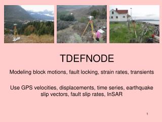
Geometric Model Generation from Structured Point Data: An Approach to Construct Geometries for Earth Science Domains Guðmundur Heimisson (heimig@rpi.edu), Cameron W. Smith (smithc11@rpi.edu), Mark S. Shephard (shephard@rpi.edu) Scientific Computation Research Center, Rensselaer Polytechnic Institute Citations & Acknowledgments Introduction Workflow Closing Remarks Preliminary Results Ongoing Work Biscay Bay The goal is to develop a workflow for automated generation of multi-layer geometric models suitable for seismic wave propagation simulations. Data Projection Geological data is typically given in latitude (), longitude (), and depth () with respect to the WGS84 reference ellipsoid. It must be projected into Cartesian co-ordinates using the transformation: • Identify and remove unwanted features: • Layer intersection artifacts caused by numerical errors. • ‘Small’ features – a feature whose length scale is less than minimal wave length supported by the analysis. • Automate non-manifold model generation • Use Simmetrix C++ API to intersect layer and bounding box surfaces. • Pursue source of layer data sets • Possibly generate higher fidelity layer representations • Simulations provide an understanding of the effect of earthquakes for which no data exists. • Simulating earthquakes accurately is of immediate concern to millions of people living in earthquake prone areas. • An automated workflow for generating complex earth science geometries would represent a significant step forward for current research, and would enable further research into this important topic. • Automated workflow demonstrated on Biscay Bay data set is significant improvement on Gambit based workflow. • Replaces hours of manual work with automated script that executes in minutes on a laptop. • Uses a robust, scalable algorithm for surface reconstruction. • Supports inclusion of multiple geometric layers. • Incorporates data from multiple data sets. • Extensible implementation using combination of Python and MeshLab. Background • Researchers at the Ludwig-Maximilians-Universität München (LMU) are working to: • Simulate dynamic earthquake rupture. • Study wave propagation through complex media in complex fault system geometries. • In order to: • Address fundamental questions in earthquake dynamics. • Generate realistic earthquake scenarios for hazard assessment. Illustration of the WGS84 ellipsoid projection. http://www.geod.nrcan.gc.ca/images/wgs84geoid_e.jpg Point Normal Computing Examples of multi-layer geometric data sets.* • The point normalsare computed using a naïvealgorithm. For each point : • The closest neighbors of are found. • The normal of is found by fitting a plane to and its neighbors. • Orientation (inside/outside) is arbitrarily assigned to the first point, and propagated thereafter. Biscay Bay geometric model: sediment to upper crust. Non-manifold Biscay Bay geometric model. Poisson Surface Reconstruction Problem • Current method of generating models and meshes using Gambit is unsatisfactory: • It requires many man-hours of manual editing. • It is difficult to integrate multiple layers. • To reconstruct the surface : • Want to find 3D indicator function . • is zero except at the boundary. • Oriented point cloud approximates . • Want such that . • Must satisfy Poisson equation, . • Find approximate solution numerically, using least squares approach. An example of a mesh generated using the current process.* Earth surface topography (colored by curvature). A reconstructed surface, with the underlying data set superimposed (colored by curvature). Trimming & Bounding Box Generation Model Generation Workflow • The surface is trimmed using a simple approach: • For each vertex in surface, compute distance to nearest vertex in point cloud. • Delete any vertex with a distance above some threshold. • The bounding box is then generated using the WGS84 ellipsoid projection. • For each geometric model layer: • Project the source data. • Compute the point normals. • Perform surface reconstruction. • Trim the surface • Once all of the surfaces have been generated: • Generate a bounding box. • Remove interface intersection artifacts and ‘small’ features. • Generate the non-manifold geometric model. Geometric Model Layers of Interest • Earth surface topography and ocean. • Sedimentary interface. • Upper and lower crust interfaces. • The Mohorovičić discontinuity. Trimmed surface with bounding box The distance field * Images courtesy of LMU. • Kazhdan, Michael, Matthew Bolitho, and Hugues Hoppe. "Poisson surface reconstruction." Proceedings of the fourth Eurographics symposium on Geometry processing. 2006. • Meshlab. Computer Software. Sourceforge. Vers. 1.3.2. CNR, VCL, ISTI. • Mark S. Shephard, Cameron W. Smith, and Guðmundur Heimisson.“Construction of Models and Meshes for Large-Scale Earth Science Applications.” SIAM CSE. Boston MA. 2012.